Mauke is Long and Low
Day 153/31
Noon Position: 20 10S 157 26W
Course/Speed: NNW3
Wind: ENE4
Bar: 1016, falling
Sea: ENE3-4
Sky: Puffy Cumulus to 20%
Cabin Temperature: 83
Water Temperature: 82
Sail: #1 and Main, close reaching; added little staysail in the afternoon
Noon-to-Noon Miles Made Good: 103
Miles this leg: 3,690
Avg. Miles this leg: 119
Miles since departure: 20,934
 We made a creeping approach to Mauke, the eastern-most of the Southern Cook Islands. Unlike its sister to the south, it did not appear at twenty miles out. In fact, it wasn’t until 0930 and at eleven miles distant that I began to see dark objects on the horizon that did not move, bunched objects and pointed ones–the island’s palms and pines. Mauke is very low.
The wind veered for a time into the eastsoutheast, and we were able to approach to within four miles, close enough to make out a beach, a large man-made structure, a point with what looked like an aid to navigation. Close enough that the lush greenness of the island was reflected back by the sun.
Like the others, Mauke is round as a donut and has no anchorages, only landings here and there, which tempered my temptation to stop. No canoes put off to call on Mo and trade pigs for iron nails. No police boat either. In fact, I saw no movement at all, even through binoculars, during the several hours it took to pass by.
What’s to know of this place?
Suddenly, I remembered I had a Cook biography aboard, the definitive Beaglehole. Aha. Here I learned that Cook first discovered the islands, islands later named for him, in 1773. Then the sighting was an atoll he designated as Hervey Island, now Manuaea. In 1776, he stopped at Mangaia (the island we sighted yesterday) on the way to Tahiti where “from the sea it looked well-wooded and attractive, though defended by a formidable reef and a furious surf. [Later] it became clear that a large number of inhabitants, much like New Zealanders in appearance, were anxious to defend it too. The Mangaians did not favor visitors. The boat sent to reconnoitre found no place to land; reef, surf, depth of water and sharp coral bottom made it dangerous to anchor … It was an unprofitable island to him, as he needed food for his cattle.”
 It was April. Cook was on his way to the Society Islands for a brief stop before proceeding for a long summer exploration of the upper North American coast and the Bearing Sea. But after departing New Zealand in March, the Discovery and the Resolution had encountered light and variable winds extending all the way to 30S where, during the 1773 passage along the same route but in June and July, winds had been favorable. Now it had been six weeks and Cook was still in … the Cooks. Bottom line, the slow going and contrary winds took him all the way to Tonga from which he doubled back to Tahiti for the winter, unable to pursue North America until the following year.
 So, not only is Mo plying much the same water as Cook, but we are getting waylaid by much the same weather!
—
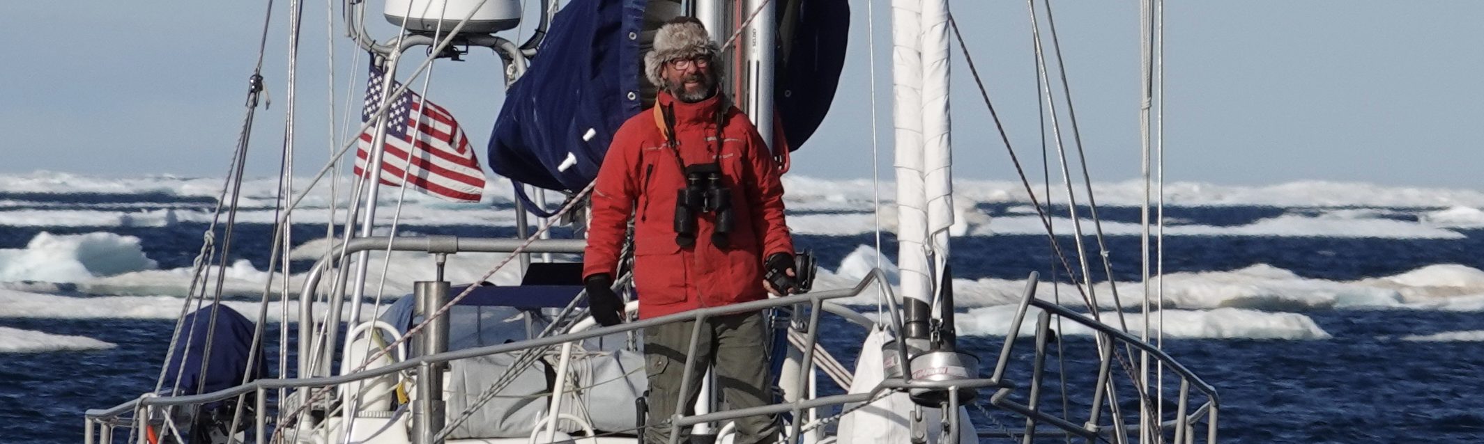
Evening. We’ve spent the day making 3 – 4 knots on 6 – 8 knots of easterly, plowing into and being stopped by the easterly swell with too much north in it. Mo just wants more sail. She’s flying a 135% jib (nearly 600 sq ft) and main (nearly 500 sq ft). But to this, in the afternoon, I added the “storm jib/staysail.” It’s a mere 117 sq ft and can’t have added more than a pound or two of push, but I felt much better for it.

Joanna forwarded an interesting question from the blog.
QUESTION
Hi Randall, I’ve been following your blog posts for a couple of months now and am inspired by your journey and your narration of the choices you make. Sounds like you’re weathering the current doldrums as well can be expected. If you’re up for explaining something to a novice sailor to while away some of the time…
As a novice sailor, I’m curious about the 3.8-knot threshold (from the May 20 post) below which you don’t bother to go above to trim sails. Is that a boat speed native to the design of Mo, or did you arrive at that number through trial and error? What’s special about that speed with regard to navigation?
Hoping you have favorable winds soon,
Jay
—
RESPONSE
Jay, greetings and thanks for following along.
There was nothing at all scientific about 3.8 knots; the speed simply felt really slow and at the same time, the best I could eek out of Mo given the conditions.
For Mo, 7 – 9 knots of true wind on a tight reach (close hauled, same thing) is plenty of wind to develop a respectable speed through the water in calm sea conditions. I would have been happy with, say, 4.5 knots of boat speed. But the chop we were heading into slowed the boat tremendously, and there wasn’t enough wind force or, conversely, enough sail flying–i.e. driving power– to overcome this. The 3.8 knots just seemed to be the threshold of the day.
So, I had to be happy with slow. Or rather, unhappy.
A boat is neither an albatross nor a porpoise, but rather she has a foot (wing/fin) in both worlds–one in the water, the keel, and one in the air, the sails. As such, she’s made to negotiate between two elements, wind and sea, not just the one that other animals contend with. This complicates things tremendously.
And every boat is unique, as is every day at sea. With Mo, I’m still learning. For all the miles we’ve sailed together, I’ve not done much lightwind/upwind work with her until this leg. Thus lots of experimentation with sail set, etc., is to be expected.
Hope that helps clarify things a little.
RR
I like the Q&A interaction with readers and would enjoy seeing Randall answer other interesting questions that may get submitted. Thanks!
Thanks, Randall, for taking me along on your voyage. I just watched wonderful video of these 2 Cook Islands on YouTube and the Mauke Facebook page. Brought back so many memories of our time in Polynesia with the wonderful, happy people playing and singing their melodic songs.
The rule of thumb with those that ply coastal nz and beyond as delivery skippers seems to be ‘maintain an average boat speed of 5 knots’ so this may mean motor sailing at times. The wisdom of this comes back to the 5-7 day cyclic weather patterns of S mid latitudes. Running at a minimum of 5 knots gives you a degree of planning certainity on a forecast of up to 3-5 days thus passage planning of up to 7 days has good odds.
No doubt in Randalls mind has been a timely crossing of the centre of the big H he has been trying to outmanouve which has taken him slowly NE over the last 5 days or so. Now that He has crossed that H thus gaining the north he wanted he has moved out of the influence of the S mid latitude weather cycle. He will be analysing the current weather cycle to his north, different rule of thumb to that of the south, not sure what it is although i suspect it uses island time.