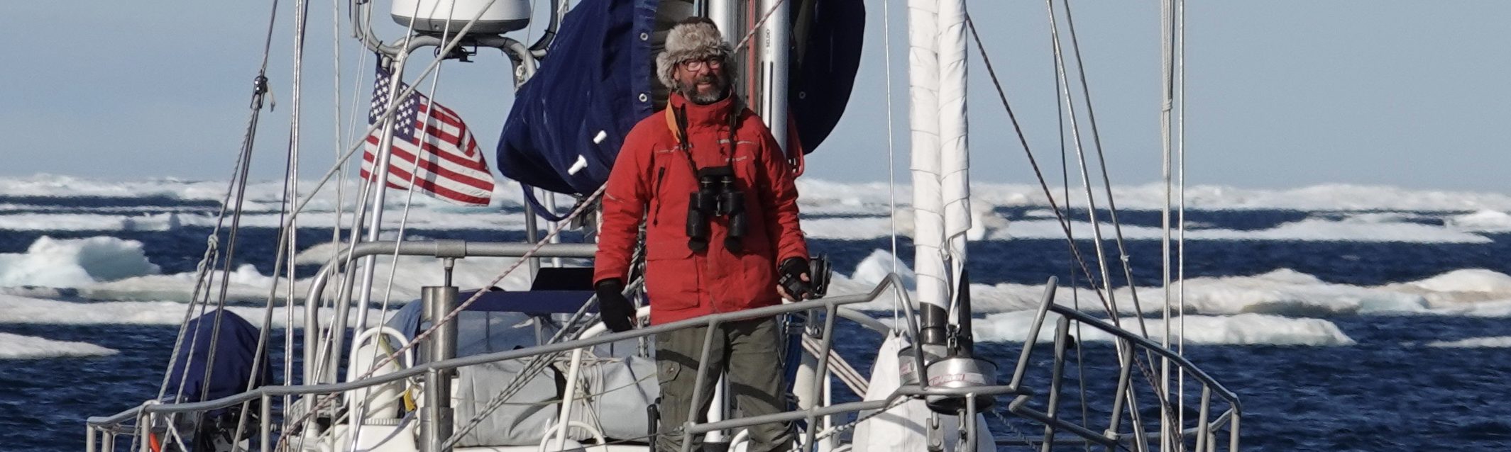

The Amazon 39, designed by Graham Shannon and built by Dieter Polluck in 1985.
What defines an able high latitude boat varies by what one defines as his high latitude area. A vessel that is ideal for Alaska’s Inside Passage might not be what one would choose upon departing the Falklands for South Georgia. Such is the case with the beautiful, sturdy and capable Amazon 39 I inspected in Port Townsend.
Built in 1985, this Graham Shannon-designed sloop was entirely rebuilt in 2000 under the direction of the current owners. Such phrases as “entirely rebuilt” can be misleading; so to be clear, she was gutted, taken down to a hull bare even of insulation and then professionally refitted with entirely new systems and furnishings. Fourteen years later, she still looks brand new.

The rebuild of this Amazon 39: new insulation going on.
Basic Stats
Steel sloop, full cabin and pilot house, hard chined, extended fin keel with skeg-hung rudder.
LOA: 39; LWL: 36 (estimated); Beam: 12.5; Draft: 7.5.
Displacement: 33,000lb; Ballast: unknown. Sail Area: unknown.
Displacement to Length Ratio: 316. Ballast to Displacement: unknown. Sail Area to Displacement Ratio: unknown. Capsize Ratio: 1.64.
Hull Plating: Not available.
Tankage: 120 gallons fuel in 2 tank; 90 gallons water in 2 tanks.
Engine: 30 hp.
Summary
From inside, this Amazon feels like a newly remodeled loft. Her open, airy salon includes a chart table to port of the inside steering station and a dining table and settee to starboard. Forward and down one step is the new galley and a small guest berth that converts into a large desk. In the bows is storage and an open chain locker. Sleeping quarters are but one queen berth aft, and the one head is adjacent, but the space to port of the berth is a large pathway to the stern systems, including the hydraulic steering gear. The engine lives beneath the cockpit sole and is easily accessible from the top and both sides.
The cockpit is small with high combings to each side but feels scarily unprotected aft. Note the steering column looks to be a section of recycled aluminum mast (clever). Also note the unique Monitor wind vane install (see photos). Decks are uncluttered and the high raised cabin provides great hand-holds while making a run forward.
I won’t get into the pros and cons of the Amazon 39 as a Figure 8 vessel; in my view, such a passage is beyond her design parameters. She’s too high sided and too heavy to be a smart sailor, underpowered for the Northwest Passage, and below she’s far too open to be a safe place to live in a seaway. That said, this vessel is beautifully detailed and well maintained and if my adventure took me only to Alaska’s Inside Passage, or similar high latitude environments, she would be a strong contender.

Hard chined hull with long fin and skeg-hung rudder.

Beefy manual windlass, medium high bulwark. Anchor locker not accessible from on deck.

Smallish, well-drained cockpit. Note unique Monitor install: the vane pendulum lines attach to a stainless tiller extending aft of the emergency rudder post. Why? This boat has hydraulic steering, which is unsuitable for the Monitor device.

Bright, open salon and galley. The cushions far forward and to port can be removed to reveal a large desk.

Galley countertops of Corian. Cupboards of maple frames around stainless mesh allow ample ventilation.

Chain locker open and accessible from within the boat.

Clean engine under salon floorboards; clean bilges.

A beautifully detailed boat.

Ed Rutherford Designed Waterline 38 built in 1989. Courtesy Boatshed.com
Next day saw me on the Bainbridge Ferry again, this time with a car headed for Poulsbo to see a Waterline 38.
One word describes first impressions of this boat: unremarkable. To my eye, her lines were common, thick and high-sided as if drawn with a dull pencil (sorry Ed).
But first impressions are unreliable, and the more I tore into this boat, the more logical and thoroughly considered her design appeared to be.
Basic Stats
Steel, cutter-rigged sloop (inner forestay not rigged), full deck-house, round chined, extended fin keel with skeg-hung rudder.
LOA: 38; LWL: 29.8; Beam: 11.5; Draft: 5.
Displacement: 22,000lb; Ballast: unknown. Sail Area: unknown.
Displacement to Length Ratio: 371 (!). Ballast to Displacement: unknown. Sail Area to Displacement Ratio: unknown. Capsize Ratio: 1.64.
Hull Plating: Not available.
Tankage: 100 gallons fuel in 1 tank; 105 gallons water in 3 tanks.
Engine: 44 hp.
Summary
One of the older yachts on the list, this Waterline showed her age, and the to-do list would be quite long. However, below the surface she was quite a well thought-out, well-built boat.
Positives from the Figure 8 perspective:
On Deck
- The small, high-railed cockpit felt safe. It allowed for easy movement around the wheel and easy reach of the winches.
- Ample deck lockers were located fore and aft. In the cockpit, a smallish locker under the stern seat was ventilated and ready for propane. A huge anchor locker forward was backed by a watertight bulkhead and had space enough for extra rode and several large fenders.
- “Sissy bars” surrounded the mast and the three winches there were self-tailing and ran cleanly.
- Strong stainless gallows cradled the boom and a rack aft, for communications and solar panels, was integrated into the aft rail system.
- Though numerous, portlights were small and fixed (a positive in high latitudes).
Below
- The layout of living accommodations was thoroughly traditional and efficient. The U-shaped galley was close to the cockpit and countertops boasted 2 inch fiddles! The head was just to starboard; immediately to port there was a cozy quarter berth.
- Center-island galley sinks covered the engine, allowing access from either side.
- Locker covers were battens (breathable), hinged and could be secured in place (important in a boat that could go inverted). Spaces under the port and starboard settee were vacant, squarish and could take extra tankage without much customization.
- House Batteries, two 8-Ds, were located forward of the galley, amidships and below the waterline but above the cabin sole.
- The boat’s electrical infrastructure, wiring, switch box location and accessibility, was all quality work.

Huge forward locker with watertight bulkhead aft of it.

Smallish cockpit; traditional house construction. Note that none of the portlights open (not necessarily a disadvantage given my destination).

Solar/communications rack integrated into stern rail (but too small for current solar array).

Traditional and efficient layout below. The sink island houses the engine, allowing easy side access. See 2″ countertop fiddles. Stand-up nav station to starboard.

The boat’s electronics were dated, but her wiring infrastructure was neatly done and quite serviceable.

Large settee lockers allowed for additional tankage to be added. Note: well ventilated.

Ideal house bank location: two 8-Ds amidships and low.
Concerns for this boat included:
- Her published displacement of 22,000 pounds (dry?) gives here a heavy displacement ratio of 371 before I move aboard and suggests the boat would be slow. (Sail area statistics were unavailable).
- The depth of refit required–topsides paint and hull, re-rigging, new sails, hard dodger, all-new electronics, etc.–was not insignificant given my current time frame.
- Lack of inside watch station (remedied with hard dodger or sight bubble).
- Minimal horsepower of existing, potentially tired engine.
All told this Waterline 38 was solid, an intelligently designed and a well-built boat, but could be too small for my needs and take too much time to ready.
Last week I flew north to inspect potential Figure 8 boats. Over four days I saw five steel and aluminum boats in yards that took me to Seattle, Poulsbo, Port Townsend, Victoria and Friday Harbor.
If I’d had the good sense to live nearer the Netherlands, I could have conducted this entire search without ever leaving the sales docks of De Valk, and fortune would have smiled similarly if I lived in France. But on the west coast of North America, metal boats are downright rare, except for one tiny pocket of manufacturing madness near Victoria, British Columbia. Here are (or were) the shops of Waterline Yachts, SP Metal Craft and Fastwater Marine, and all the boats I saw could be traced to one of these.
The next few posts will contain a quick review of the boats seen this trip, their basic specifications, brief thoughts on their suitability for the Figure 8 Voyage and some photos.
By way of reminder, in the previous post I defined the characteristics of “the right boat” as:
- Bullet-proof hull (i.e. steel or aluminum).
- About 40 feet in length.
- Capacious enough for a year’s supplies.
- Simply laid out and rigged for singlehanding (or easily made so).
One could argue that these parameters are so general as to be unhelpful. So, to be a little more specific, I was also looking for boats with:
- Good sailing characteristics (sensible sail area to displacement ratios).
- A pilot house or some kind of raised cabin that would allow for standing watch from below.
- Watertight bulkheads forward.
- Ample hull insulation above the waterline. (One metal boat owner friend of mine argues for it below waterline as well. Still thinking that one through).
- A strong power plant.
- Tankage for 200 gallons of fuel or room to add that in tankage below-deck.
- Serviceable electrical wiring and switchboxes.
- A history of (or evidence of) good upkeep such that a total, tear-it-to-the-bone refit is not required.
Simple as it may sound, the above represents a tall order when the field is so sparsely populated, and in the end my target boats for this trip comprised what was available rather than what fit the criteria.
The first boat inspected, the SK-42, was in Bainbridge, a pleasant 20 minute ferry ride from downtown Seattle.
SK-42

SK-42. Custom designed and built by Stoyan Kirilov in 2004. As the story goes, Kirilov worked for Waterline Yachts before striking out on his own.
Basic Stats
Steel pilot-house sloop, nearly flush deck, extended fin keel with skeg hung rudder.
LOA: 42; LWL: 36; Beam: 12.5; Draft: 6.5.
Displacement: 26,000lb; Ballast: 8,000lbs. Sail Area: 900 sq ft.
Displacement to Length Ratio: 250. Ballast to Displacement (after personal increment of 5,500lbs): 25%. Sail Area to Displacement Ratio: 16. Capsize Ratio: 1.69.
Tankage: 115 gallons fuel; 105 water.
Engine: 70 hp.
Summary
Neither in photos nor in person does this boat impress as being a high latitude work-horse. This is largely due to her deeply transverse transom and overlarge cockpit, which give her a racey feel. That said, her lower freeboard and robust construction suggest a boat that can charge on in may weathers. Add to this her newness and, upon inspection, immaculate upkeep–cleaner bilges I have never seen–made her a boat worth consideration.
Positives where the Figure 8 are concerned:
On Deck
- Big wheel in the big cockpit allowed easy access to winches while steering.
- Open, uncluttered foredeck.
- Ample storage locker forward with watertight bulkhead
- Stainless chainplates and standing rigging in good condition.
- Fairly low profile house for added safety at sea.
- Inner forestay could easily be rigged.
Below
- A well designed chart table and bench allowed for good, all-around view while seated, even though the windows were narrow. Bench hooked around for comfort in rougher weather.
- Super-well maintained systems if cleanliness is an indicator, and her electronics, though not new, were all appropriate to my needs.
- High quality hardware. Stainless Steel through-hull valves, for example.
- Her lower house and freeboard also reduced the boat’s internal volume, but this made her cozy for a singlehander and safe (handholds were always but an arm’s length away).

Clean open decks. A doghouse not overly high.

View inside ample anchor locker, accessible from on deck and backed by a watertight bulkhead.

A raised chart table/station. Visibility is limited due to the narrowness of the windows, but line-of-sight is clear all around. Older but serviceable electronics with Blue Sea switchboard. Galley is one step down but neatly laid out. All surfaces are beautifully done in Maple.

Well-reinforced rudder post for powerful hydraulic steering arm.

Clean engine room. Engine, transmission, shaft and stuffing box accessible from front and back (not sides).
Though a solid contender, concerns included a lack of below decks storage for such a long passage as the Figure 8 and no obvious locker-space for additional diesel tankage. The boat also felt too lightly ballasted and too powerfully rigged for a circuit of the Southern Ocean. Still, she showed extremely well, was strongly built and clearly blue-water able, having made two transits to Hilo and back with her current owner.
Next up, a Waterline 38…

Line Drawing of Jean Knocker’s Joshua 39, sailed by Bernard Moitessier. One of my all-time favorite boats, rarely available, now quite old.
In a few hours I fly to the Pacific Northwest to inspect five prospective Figure 8 Voyage boats. This article describes the search to date, including how my thoughts have evolved since this summer’s Northwest Passage.
—
“The best boat is the one you have,” is often quoted to illustrate a basic truth about voyaging: as vital as dreams are to adventure, too much dreaming, planning, revising, and perfecting can kill a cruise. At some point improvement is nothing but delay, and one must get going or risk not going at all.
In my case, however, the old saw is wrong. I have a boat, a much adored, 31 foot, full-keel ketch, named Murre. She has proven her abilities by safely transporting me over large reaches of the open Pacific (see Murre and the Pacific, one boat, one guy, two years on a big ocean). But the differences between a mostly middle latitude voyage of 15,000 miles and a 40,000 mile voyage that will spend half its time in high latitudes is vast. Compare the physical requirements on a plane flying from San Francisco to New York to a space ship’s flight to the moon. Both are technically difficult feats, but one is orders of magnitude more so. Murre is the jumbo jet in this analogy; she’s just not designed for the rigors of the Figure 8 course.

Line Drawing of Murre, a Mariner 31.
Much of my focus in recent months has been on defining the characteristics of the right boat.
And what are those?
Succinctly put, the vessel must be:
- Fast: able to maintain enough speed to get me around the Figure 8 course in one season.
- Capacious: have carrying capacity for a year’s supplies and lots of fuel.
- Simple: laid-out and rigged so as to be handled easily by one person.
- Maximally Seaworthy: capable of weathering extreme ocean and ice environments.
While these are interrelated requirements, the last is far and away the most important and has been the cause of the much recent contemplation.
Why?
Here are two visual examples of the extremes a Figure 8 boat must survive:

Sir Robin-Knox Johnston singlehanding the Southern Ocean aboard Suhaili in 1968. I keep a small copy of this painting above my desk.

From this year’s Northwest Passage, pictured here is well-found yacht Gjoa, trapped in the pack ice of Bellot Strait. Credit: Nick Walker.
And how I’ve thought about these characteristics has changed dramatically of late. It may be helpful to know that the idea for the Figure 8 came to me while reading of Matt Rutherford’s solo of the Americas in 2011. His impressive passage was accomplished in an unlikely vessel, an old, fiberglass Albin Vega that survived both the Arctic and the Horn. Murre is also made of fiberglass; it’s a material I’ve worked with extensively during her restoration. Thus, until recently, my Figure 8 focus has been on a range of vintage, heavy-displacement, fiberglass boats, like the Westsail 32.

Westsail 32 Line Drawing–inspired by the Colin Archer designs and similar to Knox-Johnston’s Suhaili, pictured above.
This is a design I’ve admired for years. Built throughout the 1970s in Costa Mesa, California, Westsails are legendary for their heft, their robustness and ability to survive even the most ridiculous of dirty weather. One now famous example is that of Sartori, the boat caught in The Perfect Storm of 1991 (you’ve probably seen the movie or read the book), which survived being rolled and abandoned only to wash up on a New Jersey beach intact.

Sartori, after the storm.
And boats like this are not unheard of in the Arctic. Cloud Nine, Fiona, Saint Brenden, Belzebub, Dodo, and Gitana are different boats of different sizes but have two things in common: they’ve all completed the Northwest Passage since 2009, and they are all made of fiberglass.
So, during the spring of this year I researched a number of stout fiberglass designs. I combed marinas in my area, flew to San Diego and Florida, and inspected vessels like the Westsail 32, 39 and 42; the Valiant 40, the Corbin 39, the Lafitte 44, the Noresman 447.
This search was interrupted by the summer’s Northwest Passage adventure with Les and Ali on Arctic Tern, and here I learned first-hand that one year in the Arctic is not like the other. In 2011, when Matt Rutherford completed his Northwest Passage, ice extents along the route were at historic minimums, and this allowed Matt to work through with relative ease. Ditto for yachts in 2012. But in 2013 the course was choked with ice much of the season, and all fiberglass yachts starting in 2014 turned back, their skippers judging conditions to be too dangerous for their vessels’ design.
Seeing the Arctic in person and feeling the immense force of ice against hull convinced me to shift gears. Since my return, I’ve been exploring only boats with hulls of steel or aluminum.
But how big? Of what design?
Let’s go back and explore the four requirements.
Fast
To complete the Figure 8 course in one season will require that I maintain an average speed of 115 miles a day. (More on the course and mileages here.) This may not seem fast to you (it is, after all, only 4.79 miles an hour), but it does to me. Keeping up solid daily runs over time can be hard work. By way of comparison, Murre has made three, month-long Pacific crossings, and her average speed over the total of those 8,000 miles was 110 miles a day. The emphasis here is on average speed over weeks and months, as with wind-ships one day is rarely like the next.
For keel boats, speed’s limiting factor is boat size. Given similar conditions of wind and wave, larger boats can go faster than smaller ones, and size, where speed is concerned, is usually expressed as the boat’s length at the water line. This isn’t the place to get into the calculation, so let me jump to the result: the Figure 8 needs a boat whose minimum waterline is 33 feet, plus or minus, and this equates to a boat of about 40 feet in length overall.
Capacious
We’re not talking cupboard space here, but rather the balance between the overall weight of provisions (the payload) and the boat’s ability to safely carry weight (carrying capacity).
These numbers add up quickly. For ship’s stores (food, beverage, galley supplies, etc.), I’ve used Niger Calder’s “Personal Increment” calculation (See Cruising Handbook, p. 13), which provides, among other things, an estimation of the weight of supplies one person requires per day of voyaging. This number, plus 100 gallons of water and 300 gallons of fuel (a range of 1000 miles under power in the Northwest Passage is not unreasonable), brings my payload to around 5,500 pounds for a year’s voyaging.
It’s not just any boat that can carry so much weight and be safe on the high seas. Again, I’ll forgo the details of ballast, displacement and their ratios and say here that this payload requires a moderate to heavy displacement boat of around 40 feet overall, and bigger would be better.
Simple
Though smaller boats are often easier to manage, simplicity is more a function of how the boat is arranged and outfitted. Here are just a few examples:
- The rig must be designed or adaptable to singlehanding. This does not mean she must be a ketch, though I have a preference for that rig, but it does mean that the larger sails of a cutter or sloop must be engineered for solo work. Headsails will be roller furling, for example, as could be the main.
- Line arrangements (sheet, halyard, reefing) should be as short as possible. Halyards and reefing lines should stay at the mast rather than be run to the cockpit.
- Cockpit winches must be within reach of the wheel or be movable to such a position.
Below decks, the layout must allow for comfortable and efficient living. Where soloing is concerned, these two terms are almost synonymous and, for me, include features like:
- The ability to stand watch from below via a cupola or raised cabin.
- Easy access to the galley and a pilot berth from the cockpit (galleys well forward and king sized beds make for a poor experience at sea).
Mechanical systems must be easy to access and reparable anywhere. This excludes boats with devices like saildrives and dedicated hydraulic steering.
Seaworthy
This is a can of worms. Don’t believe me? Then I’d recommend you retrieve from your local library Seaworthiness, The Forgotten Factor by C. A. Marchaj. It’s a serious work, as indicated by the header quote to Chapter 1, “The Nature of the Problem.”
“I say unto you, that every idle word that men shall speak, they shall give account there of in the day of judgement. For by thy words thou shalt be justified, and by they words thou shalt be condemned.”
Matthew 12:36-37
This book is 372 pages of no foolin’ around, but before Marachaj gets into the mind-boggling math, he lays out the definition simply and clearly:
“Seaworthiness–strong durable and watertight construction, structurally sound rig, good survival characteristics in extreme weather conditions.”
Given my destination (see graphics at the top of this article), this means two specific things:
1. Stays upright: the ballast, displacement, and capsize ratios yield a boat with maximum stability in large seas. If capsize occurs (far from impossible), the boat does not stay inverted. Why is this important? Here’s a good reason.
2. Survives collision: hull construction must withstand heavy ice impacts and severe groundings; better if it has watertight bulkheads fore and aft. Overhangs should be minimal; bow sprits and aft hung rudders (easily damaged by ice) are to be avoided.
Clearly there’s much more to seaworthiness, but for the Figure 8, these are the core design characteristics.
So, to summarize, the Figure 8 boat will be of steel or aluminum, about 40 feet long, medium to heavy displacement, bullet-proof, simply laid out and rigged for single handing.
Well that was easy.
Except for one thing.
In the States, the market for boats like this is small. Relative to production glass boats, few are made, and fewer still are available used. Thus far my internet research has taken me to such disparate places as Malaysia and the Netherlands, Cape Town and Turkey. I’ve looked into designs with names like Amazon, Atlantis, Boreal, Damien, Dix, Garcia, Koopmans, Kanter, Offshore, and Van de Stadt.
The cluster of boats to be inspected next week in Washington and British Columbia are the nearest to home I’ve found and include two Amazon 44s, a Waterline 38, and a Kanter.
Wish me luck!
—
Here are two of my favorite designs to date:
The Amazon 44

Amazon 44 line drawings. This design by Graham Shannon meets all the Figure 8 criteria, but is she too large for me to handle?

An Amazon 44 in steel available in Washington. Note mast furling main. Right sail for the Southern Ocean?

An Amazon 44 in aluminum available in British Columbia. Lots of freeboard. A rough ride?

Caroff designed Atlantis 400. Note relatively low profile, swing keel and (unprotected) twin rudders.

Atlantis 400 in Aluminum available in Malaysia.

The twin rudders of the Atlantis 400 do not appear to be protected from ice flowing under the boat. This boat is designed for high latitudes. Am I missing something?

Forgive me, but I’ve always thought of UGGs as girlie boots. Where I’m from they are a fashion statement preferred by teens at the mall, and consequently nine tenths of the downtown UGG shop is dedicated to such pink and frilly footware that a high latitude adventurer would be embarrassed to enter.
Knowing that, I was amazed when Les and Ali of Arctic Tern recommended them. Because my time to Northwest Passage departure was too short to allow any research at all, I simply swallowed my pride, went to the above mentioned shop, and bought the only pair of men’s boots I could find, the UGG Classic Short.

UGG Classic Short
The UGG Classic Short is a sheepskin boot whose leather shell and wool lining are a single piece of material. The shell is a light-weight suede of medium height with a lining is 17mm grade “A” Twinface sheepskin to which is attached a sole of flexible, molded foam. According to UGG, sheepskin is a naturally thermostatic material and will regulate foot temperature to body temperature in a range between -30 Fahrenheit and 80 Fahrenheit, which is quite a claim. Though “naturally high tech,” nothing about the boot feels the least bit rugged or outdoorsy. In fact, its sensation going on is more that of a bedroom slipper.
Cost: $170.00
What Worked
- Surprisingly warm: for the most part I reserved these boots for the cabin and as something comforting to change into after a watch in cold, clammy rubber boots. For this purpose they worked extremely well. Donning these boots when coming below quickly produced warm feet. On dry days I’d sometimes wear the UGGs on deck for a watch and found that in these conditions they could be warmer than the Xtratufs (though feet still got cold after extended periods for reasons having more to do with inactivity than insulation).
- Supremely comfortable: the plush sheepskin bootie and fully lined calf was a little bit of luxury (like a hot tub for the feet) and so thick that I never wore socks with UGGs.
- Breathable: Even after hours of wear, and even in a warm cabin where boots like this were not required, the UGG never became perceptibly damp.
What Didn’t
- Not for walking: while great for huffing around the boat (I even climbed the mast in them), the few times I wore the UGG on hikes to the grocery store or coffee shop it failed to keep its shape or provide much support.
- Not waterproof: OK, this UGG is not designed to be, so such is hardly a fair criticism. That said, summer in the arctic is often slushy, and any time the weather turned convincingly wet, these boots were put away.
- Sole crushing: with time, the sheepskin in the soles became compressed and lost some of its insulative properties.
- Difficult to dry: because the shell and lining are all of a piece, the lining would have been very difficult to dry if soaked by rain or sea water.
Two points in defense of UGGs
1) During the passage it struck me how similar these UGGs are to traditional Eskimo Muk Luks, which are made of soft sealskin. Like Muk Luks, the UGG is much more suited to the very cold (i.e. dry) conditions of an Arctic winter than the more typically muddy summer conditions.

Hand crafted Muk Luks. “Made of ringed sealskin from mid-calf to toes, this beautiful mukluk is warm as well as naturally waterproof. The sole is of leather and is tundra treaded for waterproofing as well as grip. Fully lined with borg (50% wool/50% polyester).” ONLY $598 from arctictrading.com.
2) The UGGs my hosts wore were not the Classic Short, but rather a much more rugged boot similar to the UGG Polson. Given their tougher shell and sole, they were more versatile than my boot by far and could take wet days on deck and muddy days on shore with ease. Still, they suffered from having a boot top just that much too short (jumping from the dinghy to the beach had to be done with care) and the permanent liner whose insulation couldn’t be dried properly once wet.

UGG Polson
In the final analysis the UGG boot’s warmth meant it had potential, and a common refrain aboard Arctic Tern was that we wished UGG made sea boots.
The previous post lays out a few options for hand protection while on a boat plying northern waters. Now, on to feet.
And I must admit up front that I didn’t quite solve the riddle of keeping feet warm and dry. I knew I wasn’t alone. Take, for example, Mike Johnson. Mike is an explorer who has sailed his large schooner, Gitana, to most places a boat can go on this globe, including Cambridge Bay, where she overwintered on the hard last year. During a visit to our house prior to this year’s Northwest Passage, Mike laconically summarized his polar gear’s successes and failures with one sentence: “It’s all ok, except I get cold feet.”
And no wonder. On a high latitude boat making stops in the Arctic, one’s feet must be prepared for three environments: the extreme cold and wet on deck, the relative comfort of life below, and tromps ashore in mud and ice.
It may be that one boot could handle all this, but I didn’t find that one boot. Instead I chose three very different solutions:
1. Xtratuf Insulated boots for on deck.
2. The Ugg Classic Short for below.
3. Columbia Bugaboot for trekking ashore.

Three boots for the three environments in high latitudes.
Here I’ll review the Xtratuf boot, and move on to the others in subsequent posts.
Xtratufs for On Deck
These brown rubber boots are the de rigeur footwear in Southeast Alaska. Developed in the 1960s for west coast commercial fishermen, they are the brand-standard for anyone on the water in a region where everyone is on the water. Loyalty to this boot is such that Xtratufs have gone beyond that of work boot and can now be found at weddings, donning the feet of toddlers too young to walk, and hanging as ornaments from the boughs of Christmas trees.
Compare these two images to get a sense of how this boot’s popularity has radiated:

Ad photo from the Xtratufboots.com site showing designed use.

One of many places Xtratufs can now be found.
Pretty photos (and an outsourcing problem that has been remedied, according to locals) to one side, these boots just work. Several styles are available, but for this year’s Northwest Passage I chose the Xtratuf Legacy Insulated boot for maximum protection. The shell of this boot is made from a tripple-dipped, seamless neoprene that is both strong and flexible down to subfreezing temperatures. The high cut helps keep water out even in the sloshiest of environments, and the chevron-patterned sole provides ample traction on a wide range of surfaces. For heat retention, a layer of foam insulation surrounds the foot of the boot (top and bottom, but not the calf). Note: much like the Atlas gloves in the previous post, this boot is designed to take inserts in the form of warming insoles and “Sokkets.” I used the Servus 3/8ths inch felt insole (see “Layering Options” below).

Xtratuf Legacy Insulated boot.
Cost: Boot-$120.00. Insole-$7.00
What Worked
- Tough as advertised: The shell is highly puncture resistant and durable, and unlike other materials, doesn’t break down (get sticky) in the sun or when stored for long periods in a boat locker. I have a well-used pair (uninsulated) bought in Hawaii in 2011 that have seen heavy use since, and the only sign of wear is a split in the rubber between the cuff and boot, easily repaired using several methods.
- Unquestionably waterproof: the seamless neoprene construction is simple and a reassuringly “no fail” solution. With foul weather gear pulled down over the high tops, I found my feet stayed dry in even the wettest weather.
- Layering Options: I bought boots a full size larger than my normal footware. This allowed me to put in not just one but two insoles or to double up on thick socks when conditions were especially cold. Additionally, insoles and socks that had become damp and clammy could be easily changed for a fresh, dry pair. I took three pairs of insoles and six pair of Smartwool Mountaineering socks.
What Didn’t
- Not warm: that “rubber” boots are not warm is a common lament among high latitude sailors, but I’m not sure this is entirely the fault of the boot. Granted, the neoprene always “feels” cold going on, but I think the main culprit is our inactivity. Much of standing watch is just that, standing, and with little to keep the blood circulating, it’s no wonder our feet freeze. To be fair, I attempted to get blood moving by shifting my stance and walking in place while on watch but with little success. And it’s important to note that my feet got cold in other boots too.
- Not breathable: again, this is a qualified criticism as the boot makes no pretense toward breathability. That said, because boots are worn for such long periods, moisture does tend to build up inside and lend to the feeling of cold.
- Not good for walking: all that insulation (including the insoles and thick socks) make this boot too chunky (and hot!) for anything but short walks ashore, but that’s a function of this boot. I’ve hiked many a Southeast Alaskan town in uninsulated Xtratufs in relative comfort.
What I Opted Against
- Bama Sokkets (by Honeywell for Xtratuf): these are removable, insulated boot liners made to wick moisture from the feet to the boot wall. Great idea, but in my experience they are a fiddle to get on and off, and my feet exit the Sokket after a long watch as damp as ever.

The Bamma Sokket for Xtratuf boots.
- Permanent “sheep skin” linings: the Viking Trysil with pile liner is one of several brands I chose against because of the difficulty of drying the insides once wet.
- Gore-Tex insulated boots: the Durbarry of Ireland line is the hot, new thing in sailing boots, but in addition to a gob-smacking price tag ($399 a pair), I’m hard pressed to see how Gore-Tex could wick moisture out of a non breathable, leather shell. Also, feedback I’ve received from other Arctic sailors suggests they are not a warm boot for the north.
Summary
Though the Xtratuf Legacy Insulated boot failed to keep my feet toasty-warm, the boot’s durable, seamless, high-top construction, its good grip, and options for layering in extra warmth make it a superior boot for high latitude deck work.
Up next: boots for inside the boat…

The breadth of selection is mind-boggling. Take, for example, the types of gloves available to cold-weather commercial fishermen. Even in this market subset, the sheer number of options and materials warrants its own junior college introductory course. Add to this the mountaineering brands, the sailing brands, and trying to find the best piece of kit can appear a futilely complex exercise.

Glove Isle of Commercial Fishermen’s Store SEAMAR of Seattle
I chose to try two very different glove solutions for deck work in the Arctic, low-tech commercial fishermen’s “rubber” gloves and high-tech Sealskinz. Also noteworthy are the NRS Titanium kayaker’s gloves mentioned below.
Fishermen’s Rubber Gloves
For deck work I primarily used the orange “rubber” gloves so ubiquitous among commercial fishermen, specifically, the Atlas 465 gloves with separate liner. The Atlas outer glove is a double-dipped PVC material that is cut and puncture resistant and remains flexible down to -20 degrees Celsius (-4 Fahrenheit) and has a roughened grip for handling slippery objects. The yellow liner is made of a seamless, plush acrylic.

The Atlas 465 Glove with Separate Liner
In preparation for very cold work, I bought the extra-large size in these gloves and then purchased two sets of liners, large and medium–one to go inside the other, with the intention of having three layers of protection.
Cost: $16.00 for the glove; $7.00 for the liner.
What Worked
- Worry-free waterproof-ness: unlike my seamed, high-tech mitts or the below mentioned high-tech gloves, their ability to protect was not in question.
- Easy-dry liner: though I only took one set of outer gloves, I brought multiples of inserts (5 sets), which meant I could quickly trade wet for dry, and wet liners dried quickly.
- Active warmth: because I wore these only for active jobs like handling anchor chain, dock lines, tacking, reefing, etc., I never found I needed more than one insert. As long as I was using my hands, they stayed warm in this protection. (These were not warm gloves for low-exertion tasks like steering and just standing watch, nor did I wear them for that purpose.)
What Didn’t
- Triple layer protection: the idea of putting on two sets of inserts inside the rubber shell never became reality. It was too time consuming, and because I reserved this glove for active work, unnecessary in the kind of cold I experienced on the Northwest Passage this year.
- A size too big: because I was using only the one insert, the extra-large out glove size was too big for “fine” work. When reefing or tacking, the fingers frequently got caught in the line or made the work of finishing a knot or cleating a sheet too cumbersome.
- Difficult to put on quickly: having two layers (shell and liner) made these gloves a fiddle to get on, especially if one’s hands were damp or sticky. I experimented with leaving the liner inside the glove (as with the Alti Mitt) but found fingers rarely made it in without bunching up the liner material. Typically the liner and glove had to be donned separately.
- Cuff size: the cuff was of medium length but too short and narrow to fit over foul weather gear and too large to fit under. I suspect the cuff is designed to go under the large sleeve of a commercial fisherman’s “rubber” jacket, like those made by Grunden.
The Atlas 465 gloves are a low tech, no-nonsense, cheap, and nearly indestructible solution. Even if one opts for carrying a more cutting edge solution, having a pair or two of these gloves in the locker as backup is enthusiastically recommended.
What I Opted Against
- Permanently insulated gloves, like the Atlas 460 series or the Atlas 282 Temres series. I’ve used the 460s on ocean passages and find that though this glove solves the problem caused by having separate pieces, it can be difficult to dry if the attached liner gets wet (and it will get wet) because it’s surprisingly tough to turn fully inside out.
- Partially “rubberized” gloves, like the Atlas Fit series. I find they get wet too easily and are slow to dry.

Atlas Thermafit Glove
High-Tech Gloves
I also brought a pair of Sealskinz Ultra Grip. These are designed to be close-fitting and are advertised as waterproof, windproof and breathable. The out shell is mostly Nylon with a “hydrophilic” membrane and an inner liner of merino wool. Dotted palms assist with grip.

Sealskinz–Waterproof, Windproof, Breathable
Cost: $50.00
What Worked
- Great for fine work: because the Sealkinz were so close-fitting, they were excellent for jobs that required tying knots, cleating-off lines, handling tools, etc. With some practice, I found I could accomplish tasks in these gloves almost as quickly as if I were working with bare hands.
- Delaying cold: these gloves slowed the invasion of cold that can come from handling cold objects, and in this way were far superior to working with bare hands. However, unlike my experience of Atlas gloves, hands in Sealskinz never felt warm. It could be that I bought a size too small and that there was simply too much pressure on my fingers to allow ample circulation. Delaying cold is not a bad trade for the ability to do fine work on deck.
- Quick-drying: The glove dried rapidly when hung over the stove.
What Didn’t
- Not entirely waterproof: either they weren’t waterproof or they weren’t breathable. Either way my hands often came out of these gloves feeling wet.
- Not entirely warm: delaying the onset of real cold is a good thing, but not the same as having warm hands.
This high-tech solution bought me more time to do “fine” tasks on deck than bare hands, but did not effectively keep hands warm or dry.
What Didn’t Get Tested

NRS Titanium Neoprene Glove
I brought but failed to try the NRS Maverick Glove with Hydrocuff. This is a cold-water kayaker’s solution made of 2mm neoprene. It has liquid sealed seams and an arm-gripping cuff, so its warmth should compete with that of Sealskinz while being entirely waterproof (and non-breathable). The fingers aren’t as close-fitting, so dexterity may be minimally reduced. The pair I have (size: large) are very tight going on, especially with already-wet hands, and it’s this difficulty which left them in the bottom of my duffel bag for the year’s Northwest Passage.
Summary
Remembering the three basic criteria, that the item must be 1) waterproof; 2) easy to don; 3) easy to dry, the clear winner in this post is the simple and rugged Atlas 465. These have the additional advantage of allowing working hands to be feel warm in very cold conditions for about half the price of the competition.

My favorite solution is not always the most expensive. Someone please tell my wife.
In a sense, I got lucky. A mere nine shopping days separated my landing the berth on Arctic Tern and my expected arrival in Nuuk. Time was short, investigations rushed. I just happened to be passing through Seattle on the way home from a Vancouver delivery and took that opportunity to visit the world’s largest REI and the Outdoor Research factory store. In June, I found, only Outdoor Research had anything like a selection of Arctic-ready mittens.
I chose the Outdoor Research Alti Mitt for when needed warmth trumped that of dexterity. According to the manufacturer this mitt is “built for 8,000 meter peaks and Arctic expeditions,” and though I wouldn’t know about the former, it served well in the latter.

Outdoor Research Alti Mitt–Shell and Liner
The Alti Mitt is actually two in one, an outer shell with an inner liner. The shell is made of a waterproof Gore-Tex with a leather palm. It has Prima Loft One insulation on top with fleece on the underside. Large, long cuffs allow easy fit over the sleeves of foul weather gear and gaskets can be cinched to reduce the intrusion of wet stuff. The liner mitt employs the same insulation strategy as the shell, but there’s more of it. The two pieces can be worn separately or together.
Cost: $199.00
What Worked
- I have a hand of average size but bought the large mitt to ensure ample room inside to trap warm air and reduce any pressure from material on the skin (pressure reduces circulation). I could comfortably put the thumb in with the other fingers and even make a fist of my hand, all within the mitt. This, combined with the insulation, made the mitt very warm under most circumstances.
- The long, large cuff extended easily and without much fuss over the sleeve of my foul weather gear. The lengthy overlap between foulie cuff and that of the mitt ensured “seamless” warmth between hand and arm.
- Even though the cuffs fit over the foul weather gear, I found that rain did not easily make its way inside. On two occasions I stood a rainy watch at the wheel in these mitts and in neither case did the liner get wet. (I can’t explain this.)
- The leather palm remained waterproof, even in the wettest weather. (See below re Gore-Tex palms.)
- A velcro tab attaches the liner to the shell, securing one to the other and making the mitt easy to get in and out of.
- Even after weeks of use, the mitt had a plush, warm, luxurious feeling, and was a joy to put on.
What Didn’t
- The fleece insulation on the palm-side of the mitt (both shell and liner) was insufficient to block the intrusion of cold when gripping cold surfaces for long periods. This is the Alti Mitt’s single biggest drawback.
- With rough use, the liner slid around inside of the shell. The two Velcro tabs at the base of the liner were not enough to stop this.
- Outdoor Research would not sell additional liners. This meant I had to be extra careful not to wet or lose the one pair I had. That liners are not sold separately seems a miss-step on the part of the company.
- The liner felt too lightly built to be worn on its own, and because I had only the one pair, I chose never to do this.
- With prolonged wetting, the grip of the leather palm became slick and slippery (though it remained waterproof). This result was not unexpected and was preferable to Gore-Tex (see below) while being far from ideal.
The Outdoor Research Alti Mitt is an excellent piece of kit for light duty work in cold temperatures but could do with extra insulation in the palms and a more secure connection between the shell and the liner. I intended to experiment with inserting another, light fleece mitten inside the liner for added warmth, but never found such an item for sale in the Arctic hamlets we visited.
What I Opted Against
- Mitts with Gore-Tex palms. In my experience water can be forced through Gore-Tex given the right amount of pressure (after a few rainy sits, the seats of Gore-Tex foul weather bibs, for example, seem to leave me with a damp bum).
- Mitts with a separated index finger. The reduction of space in the mitt’s main compartment make for cramped quarters when all four or five attempt to snuggle together and seemed a poor trade for minimal added dexterity.
- Glove Liners. A few manufacturers and one salesperson recommended a glove liner to go inside the mitt shell. Such seemed to defeat the purpose of a mitt, which is to create a single warm compartment where naked fingers can warm themselves.

Outdoor Research mitt with Gore-Tex Palm and Free Index Finger
Looking back now I can’t imagine attacking the Arctic without a large, waterproof, well insulated, long-cuffed mitt and was amazed at the number of cruisers in the north who only had gloves.
Next, Fishermen’s “rubber” gloves vs a High Tech solution…

At the Wheel of Arctic Tern in a Cold Rain
Joining Les and Ali on Arctic Tern for the this year’s Northwest Passage ticked several Figure 8 boxes, one being the testing of high latitude gear for my own solo attempt. In the next several articles I’ll review the gear I carried, what worked and didn’t work, and what I learned, starting with mittens and gloves…
—
Keeping hands warm and functional in high latitudes is a challenge; hands do too many things and the weather varies too much for there to be a one-size-fits-all solution. At best one gets a compromise, some middle point between comfort and usefulness, and even that requires experimentation.
First, to set the stage:
This Year’s Conditions
Average temperatures during the two months of the passage above the Arctic Circle were 3 – 6 degrees Celsius (37 – 42 degrees Fahrenheit) with many days at zero degrees and below. The lowest temperature measured was -8C (17F). It rained frequently and snowed or hailed on several occasions, usually when winds were strongest. Winds averaged 10 to 25 knots on deck with many days of calms and several of 35 knots plus. See this article for more on general conditions. Given what I’ve read and heard from others, I’d rate the summer weather we experienced as fairly mild.
The crew of Arctic Tern stood 3 hour watches. If the weather was particularly rough or particularly cold, the person on deck would be given a short break after an hour or so. Still, it was not unusual to be on deck for the entirety of one’s watch.
Defining Warm
I found that in the colder weather no piece of kit, be it hat, boot, or glove, would keep me warm indefinitely, and under most circumstances, life on deck was within a range most would define as convincingly chilly. Very crudely the perception of being cold in the body’s extremities passed through three stages: 1) simple cold; 2) aching cold; 3) numbing cold. The first was a natural state of working in the Arctic; the second, a frequent result of spending time on deck, but the third was to be avoided at all costs. After some weeks, I began to judge a piece of kit’s ability to keep me warm by how long I could be on deck during a single watch without passing into stage three coldness.
Mittens vs. Gloves
Much of one’s time on deck is inactive, where hands are concerned; for example, holding on while standing watch, gripping the wheel, etc., requires too little energy to pump much warm blood to the extremities. Under such circumstances gloves can be cold comfort as, in my experience, separating digits into their own compartments makes them incapable of warming themselves. For such times nothing beats a pair of loose fitting mittens. Conversely, I found active hands can be kept warm in gloves even in very cold situations, like working with freezing anchor chain or reefing an icy sail.

Hand Coverings for Different Situations
Bare Hands
An acquaintance of mine who has gone twice through the Northwest Passage told me he uses bare hands when working on deck. He is a skilled photographer, among many other things, and gloves make operating small equipment difficult. I worked the foredeck with bare hands in very cold conditions many times, but found that unless my excursions from the cockpit were short, my fingers soon became too cold to be useful. On one occasion I returned to the cockpit after muscling a reef into the main barehanded only to find that my fingers were too “brittle” to undo the clip on my safety harness. I had to be helped out of my own gear! So, unless the situation demanded urgent action, I usually opted for gloves.
Three Requirements
Each piece of kit I took, whether a mitt or a glove, had to be
- Waterproof.
- Easy to put on/take off.
- Easily dried, especially inside.
The first of these is a base-line requirement as wetness, on a high latitude boat, is everywhere. Precipitation, spray, condensation, wet material like lines and sails mean that a porous mitt or glove will lead to wet, and thus cold, hands much sooner than later. The second is driven by the many requirements of hands. Mittens may be great for steering, but what happens when one jumps forward to make a sail change or below for a cup of coffee? Being able to get into and out of hand coverings without thinking about it is a premium quality. The third requirement is a result of the first two. No matter the care that is taken, the insides will get wet eventually and must be of a material that is easy to disassemble and open to the air. In this way, gloves and mittens whose inner insulation is a separate piece are preferred.
Given those requirements, my assessments of the mitts and gloves I used on this year’s Northwest Passage are in the next few posts…

In a recent post (here) I sketched out 2014 Northwest Passage Stats and where I thought Arctic Tern fit in.
Here are a few more data points, this time focused on our particular experience. (What follows is from my log and is presented here for interest’s sake only.)
Mileages and Days
- 4167: Miles Arctic Tern sailed between Nuuk, Greenland and Nome, Alaska.
- 1866 / 2301: Miles from Nuuk to Bellot Strait (note side trips) / Miles from Bellot Strait to Nome.
- 45 / 20: Days to make Bellot Strait from Nuuk / Days to make Nome from Bellot Strait.
- 65: Days between Nuuk and Nome.
The course through the Northwest Passage is remarkably long, especially if one considers the miles to the Arctic Circle from home waters and the additional miles to “safe” water below it. Add another 2500 miles to Arctic Tern’s season from her start in Lewisport, Newfoundland to her projected winter quarters in SE Alaska, and you can see that in distance alone–not counting the difficulties of weather, pilotage, shortness of season–the passage requires a high degree of commitment.
Though Bellot is not the actual midpoint of the course, it acted, for us, as a threshold such that we tended to think of our passage as before Bellot and after Bellot. For example, almost all our ice encounters in 2014 were at and before Bellot, as was all the time we spent waiting for ice to clear.

Ice Encounters
In hindsight the time we spent up close and personal with pack-ice seems quite small. According to my records we had 10 specific ice encounters, which I define here as contact with floe or floe whose proximity required evasive action. I have not tallied work with icebergs in Greenland as they could be approached more or less on our terms, and they were only of any density in Disko Bay and near Upernavik.
In order of appearance:
- August 8: Arctic Tern works her way out of an ice plug covering the entrance to Cumming Inlet. Though the plug is not very wide, it is 7 /10ths on the western edge thinning to 3/10ths at the eastern edge. Given the heave of swell, it takes time to find a clean way out.
- August 9: We pass through loose pack entering Admiralty Inlet.
- August 17/18: We move through 1 – 3/10ths ice exiting Admiralty and working around Cape Crawford. Density requires numerous course adjustments but little reduction in speed. Water-top covered in nilas.
- August 22: Loose pack must be avoided upon entering Port Leopold but requires only occasional poling. Light W wind clears the anchorage by morning.
- August 23: While attempting a leap from Port Leopold to Fort Ross, Arctic Tern encounters the pack around Prince Regent Inlet’s Creswell Bay and is turned back. After several hours of working 1 – 3/10ths ice, we come upon a patch of what appears to be 7/10ths. From the spreaders we can see leads, but none are long and we are unable to connect more than one or two leads together before coming to a dead end. The ice is not moving, and we can expect little near-term change. Instead of wasting precious fuel and in order to manage a coming southerly, we back-track to Fury Beach and anchor behind a small spit on the north side of Fury Creek.
- August 23/24: Overnight Arctic Tern is swept out of her Fury Beach anchorage when the current makes a sudden 180 degree shift in direction and accelerates. A larger piece of floe that has been slowly retreating is quickly upon us. All hands! The ice impacts our starboard bow and anchor chain. Shore lines are cut loose; anchor chain is paid out while two of us pole furiously to free the chain. Too much pressure. Bow is being dragged down. We are preparing to buoy the last of the chain when the anchor is plucked up. Arctic Tern is swept narrowly past the ice piled up on Fury Beach spit and then the shoal at the creek entrance. With sea room and a decelerating current, we are able to disengage from the ice.
- August 26: Ice invades our Fort Ross anchorage just after breakfast of our first morning. We depart without issue, but Novara’s anchor is briefly impacted. Brands Island anchorage is full of ice. We move to Levesque.
- August 26: By late evening, the ice pack is invading Levesque, so we again weigh anchor and move to escape. This time both Novara and Arctic Tern must push their way out, leaving a fair bit of bottom paint behind.
- August 29: Arctic Tern attempts to pass Bellot Strait. Two ice plugs within the strait give us pause when viewed from a distance, one extending southward toward Zenith Point and another extending northward toward Halfway Island. Upon approach, both have near-shore gaps we pass through easily. A larger plug covers the entirety of the western entrance to the strait, but current action creates significant ice movement. Novara squeezes through the northern band, and with patience we are able to “wedge and pole” our way out.
- August 30/31: From Franklin Strait’s Tasmania Islands to Cape Victoria, Arctic Tern hugs the coast closely and can usually see ice to starboard but must negotiate loose pack only twice.
- Though pack ice is often “near” (as we pass Ice Breaker Channel, round Bathurst, round Barrow) we do not see it again the remainder of our passage.
 Climate
Air Temperatures
- 5C: Departing Nuuk
- 3.5C: Lowest temperature while crossing Baffin Bay; wind from NW.
- 0C: While maneuvering in ice upon departing Arctic Bay.
- -1C: With snow and 30 knot winds in Lancaster between Rigby and Graham Harbors (with wind chill, -8C).
- 8 – 10C: In Simpson Strait.
- 0 – 3C: Cambridge Bay to Cape Bathurst and 2 – 6C: Bathurst to Barrow.
- 7C: below Barrow.
- 3C to 6C: Range of temperature on most days between Lancaster and Barrow.
Sea Temperatures
- 7.78C: Day after departure from Nuuk.
- -1.05C: Upon our encounter with the ice pack south of Creswell Bay and one of the coldest seas we recorded.
- 8.18C: Temp at Cape Lisburne.
- 10.21C: Temp just outside Nome.
- 2.5C to 4.5C: Average range of sea temperatures between Lancaster and Point Barrow when not in the company of ice.
Barometer
- 1021mb: Highest reading.
- 994mb: Lowest reading.
- 1000mb – 1015mb: typical range.
- 11: days with readings of 999mb or below.
Wind Force (wind blew from every conceivable direction except up; direction is not summarized here).
- On 18 days we recorded winds of Force 0 – 1.
- We had winds to Force 5 – 6 on 6 days.
- Force 7 was recorded on 3 days.
- Force 8 on one day (anchored in Cumming Inlet).
- The rest of days were Force 2 – 4.
Fuel Stops
Given the generally light or contrary winds and the requirement to make miles when we could, we motor-sailed or motored 70+% of the time and replenished fuel supplies in:
- Nuuk
- Upernavik
- Arctic Bay
- Cambridge Bay
- Tuk
The longest legs were Arctic Bay to Cambridge Bay (677 miles) and Tuk to Nome (1061 miles). We had our best winds between Tuk and Nome, motored the least during this leg, and arrived in Nome with much of our fuel aboard.

Upernavik Fjord. Why Leave Greenland?
A request in the comments of a recent post, “What’s it like to be back?” resulted in a response worthy of its on post.
The requests from Douglas Pohl, who authors Northwest Passage 2014:
“1) Please detail your NWP expenses. 2) If you were to go again – what would you seek out to make the experience better for you a second time? 3) Less than half of the yachts attempting a NWP made goal. What items/events/preparations/decisions made the difference between success and failure?”
My response:
First, a caveat. I’d never been to the high latitude north before this year and went there specifically to learn the weather, pilotage, and endurance challenges associated with my own upcoming attempt. I just got lucky to land a crew spot with Les and Ali on Arctic Tern, who brought a tough boat and an anchor locker full of experience to the problem. It is they who should be answering these questions.
Understanding that…starting from back to front…
3) What items/events/preparations/decisions made the difference between success and failure?
I think the main challenge of any expedition, beyond exploring deeply, is to return home with vessel and crew in one piece. So, I have nothing but respect for the skippers who, after spending weeks on the NWP, decided the risks were too great to continue. We go to rugged places to see life in the raw and to choose for ourselves how to solve their problems. Deciding to retreat from the arctic is no cakewalk given late season weather in Baffin and Davis and can be an adventure in itself. So cudos to all who attempted and got out safely.
Given that, my responses are as follows (not necessarily in this order):
a. A Metal Boat. Many have demonstrated that a metal boat is not a requisite hull material for the NWP. Cloud Nine, Fiona, Saint Brenden, Belzebub, Dodo, Gitana, just to name a few made in glass. While in Nome I met Roland, who manages the yard where you will haul out on your way south, if such is your choice. He went through the NWP in a wooden Bristol Channel Cutter in 2009, demonstrating again that pretty much any boat can do pretty much anything.

Arctic Tern is a Bruce Roberts 43 made of steel.
That said, having the reserve strength of metal in the hull gives your NWP crew the confidence to take the risks an ice passage can require. Arctic Tern was swept off her anchor by heavy ice at Fury Beach and punched through ice plugs in Bellot, Depot and Levesque. We had many concerns during these events—holing the boat was not one of them.
b. Access to Ice Reports. One boat’s crew we knew turned back because they didn’t have daily access to Environment Canada Ice Reports. Arctic Tern benefited from the help of a shore-based monitor, not an arctic expert, rather a computer-handy friend who could clip those portions of the ice reports we needed and compress them for daily send over SSB/Pactor. Other boats with Iridium technology got better, prettier pictures (at sometimes much greater cost), but our snippets were plenty to allow us to make the decisions we needed.

A full color report. What we got was a tiny snippet of this, but good enough!
c. Good at Playing Poker. Success at the NWP in 2014 required waiting, almost endlessly, for the right moments and aggressively taking the opportunities when they came. I got to learn from Les here, who pushed Arctic Tern to the edge of the pack (from Graham to Port Leopold then to Fury and Fort Ross, for example) so that when ice did shift we were in position to take advantage of it.
d. Confidence of Experience (but not overconfidence). Les and Ali had the advantage of significant high latitude experience and the lessons from their 2013 attempt, making them, in my book, the best bet in the 2014 field. That said, Les spent hours with the ice charts, forecasts and the Arctic Pilot. Reading, thinking, reassessing his plan. Always reassessing his plan! This gave us a huge advantage.
2) If you were to go again – what would you seek out to make the experience better for you a second time?
a. Delay a Baffin Crossing. We crossed over too early. We knew this and did it on purpose because early ice charts showed considerable clearing in Pond and further on. There was, we thought, the chance for a repeat of blue-water years like 2012. This turned out not to be, and so we got to fully explore Devon and Arctic Bay in exchange for Greenland north of Upernavik. Not the worst of exchanges, but … OH Greenland … how we missed you!
b. Beyond that, it’s a tough question. We had good food, fresh bread, a heated cabin, arctic streams to drink from, heavy ground tackle, a solid boat, a strong engine, a big gun, two inflatable dinghies, good companions, access to weather and ice reports, and the ability to communicate with home. All on a 43 foot boat!
1) Please detail your NWP expenses.
Again, I was one of several crew, so did not have access to the boat’s overall expedition expenses. From my observations, the biggest expenses on the NWP are a) fuel and b) food.
By my estimation, we motored or motor-sailed some 70% of the time, and we refueled in Nuuk (Arctic Tern began her attempt from Newfoundland), Upernavik, Arctic Bay, Cambridge Bay and Tuk. Given the distances and fickle winds, a sail-only passage was not an option and carrying large fuel supplies, 1000 liters, added greatly to our ability to efficiently get through.
Food in the Arctic is expensive and the selection is poor. Stocking up early, say, in Nuuk, is recommended. I found cans of stew in Arctic Bay that were $12.89. Overall prices for grocery store items appeared to be twice that of “normal” stateside and fresh vegetables often appeared way past “sell by” dates.

Food can be expensive in the north.
For crew traveling to meet a boat, plane flight expenses were considerable. Getting to Nuuk from my home in California was several thousands of dollars.
Other expenses were nominal: no marina fees, no expensive dinners in restaurants and bars, both of which are in short supply in the arctic, etc.

Big Berg in Disko Bay.
The most frequent questions I get now that I’m home from the Northwest Passage are:
- What’s it like to be back?
- Would you go again?
The answer to the second of these is unequivocal, but the first is nuanced and requires some explaining.
The Northwest Passage was a domestic affair, from a certain perspective. Apart from a short sojourn in Greenland, the entirety of the voyage occurred within my “home” waters of Canada and Alaska.
That said, I’ve never traveled to a place more foreign. The sensation was of breaking our orbit to awaken on the shores of some other planet. From the discombobulation of 24-hour daylight to the invasive, grinding ice and its inescapable cold to the deep quiet of desert mountainscapes barren of trees and largely free of humans, the Arctic was decidedly not mother earth. So, returning from two months in the far north has been a stranger re-entry than my two years alone in the tropics.
On the one hand, I feel a certain pride associated with being part of a team that succeeded at a complicated, risky venture. No, not every moment was dangerous or even difficult. On Arctic Tern we baked bread several times a week; we read books in a heated cabin; we posed for pictures; we drank red wine with dinner. But the challenges of the next day, the next ice choke, the next gale, the next two thousand miles to Barrow, were always in the back of the minds. We knew we were on our own and had to rely on ourselves to get through.
Some of the self-reliant activity was quite exciting. I won’t quickly forget our piloting Arctic Tern through the ghostly pack, giant chess pieces askew, the loose frazil tinkling like chandelier tips, or standing watch in 30 knot winds of zero degrees and snow or reefing sail with hands so cold they ached as if from intense heat. After one such experience I returned to the cockpit only to find my fingers were too “brittle” to operate the life-line clip. I had to ask for help getting out of my own gear. We poled-off bergy bits in Port Leopold; we were swept by ice off Fury Beach; we cleaved it with the ship’s bow in Bellot. These were the moments one goes to the Arctic to find.
Far more usual and wearing, however, was constant decision-making and reassessment of the plan. The Northwest Passage is a maze scattered with ice doors that open and close during one’s transit, sometimes predictably, sometimes not. Each of our hard-won advances into the maze—to Port Leopold, Fort Ross, through Bellot, around Bathurst—came with the danger of removing our ability to retreat if further advance became impossible. Intricate weather and ice reports, whose receipt was often delayed, had to be weighed against our own, local experiences. Should we take the opportunity of a possible clearing of the ice in Prince Regent Inlet or wait for a similar opportunity in Peel Sound? If we pushed on another thousand miles, could we retreat at all? What if we became embayed?
So, satisfaction at our success nestles next to a relief at having escaped.
And under that is disappointment, a gentle sadness that the adventure is now in the past and that I have left a place, so rich in interest and history, largely unexplored. Each strait, each cape and point is named for explorers from ages past, yet it still feels like virgin territory. On Fury Beach we found barrel staves from Parry’s expedition of the 1825. Here HMS Fury was wrecked, her supplies offloaded and cached, coming later to the aid of John Ross’s expedition of 1829, and here, while searching for fresh water to replenish Arctic Tern’s stores, I found the tracks of arctic fox and musk ox and came face-to-face with a polar bear. Every landing had moments like this.
Yet I can count our visits ashore on two hands. How often skipper reminded us that the Northwest Passage is not a pleasure cruise! Even on fine days one knows that the region, this bay, this peak, everything that one can see, will soon be frozen or whipped by winds that drop temperatures to inconceivable depths. Everywhere Arctic Tern sailed from Upernavik, Greenland to Nome, Alaska—that entire 3,000 mile voyage—is solid ice most of the year. Thus attendant on wonder was a sense of urgency. One must keep moving or risk not getting out. Hikes were brief; we did not dally at anchorages. Painfully, we were pulled away too soon.
Balancing all this is the sweetness of returning home, to the company and friendship of my wife, the smell of trees, the song of titmice in the back yard, to the familiar warmth of Indian summer in California.
So, what’s it like to be back? It’s a mixed bag, a jumble of related sensations all present at once and currently unsettled. I’m guessing this is pretty normal.
And would I go again?
Yes. In a heartbeat.
What follows are some of my favorite photos of Arctic Tern’s 2014 Northwest Passage:

At a Crossroads in Nuuk.

Taking Water in Nuuk; Ali Chats with the Water Superintendent.

Whale Bones in Aasiaat Harbor.

Bergy Bit in Upernavik Harbor.

Mountains and Bay Behind Upernavik.

Upernavik from Hilltop and Looking out to Sea (note collection of big bergs in the bay).

Passing a Berg upon Departure from Upernavik.

Staying Clean and Tidy during the Crossing of Baffin Bay.
On Approach to Devin Island.

Les and Ali in an RCMP Shack Near Dundas Harbor.

Musk Ox Remains Near Dundas Harbor.

The Walruses of Cuming Inlet.

Arctic Bay Church and Longboat.

A Dog Poses in Arctic Bay.

Children at Play during the Grounding of Gjoa.

Ann, Glenn, Les and Kids–Pleased at Bringing Gjoa Successfully to the Beach.

Our First Push South from Devon: Snow and Strong Headwinds.

Nick Poling ice in Port Leopold.

Ice piled on Fury Beach spit.

Polar Bear, Levesque. He hung out as if performing.

Gathering on Tug Tandberg Polar at Fort Ross. Captain in Smart Sweater.

Fort Ross Shelter.

Slushy Stuff off Cape Victoria.

Gjoa Haven emerges from Fog.

Coming Into Nome: Les and Ali Pleased at the Accomplishment.

Arctic Tern Happily Making Waves off Nome’s Sledge Island.

Arctic Ternies Celebrate a Successful Northwest Passage with the Novaras in Nome.

The Crew of Arctic Tern: Randall, Ali, Skipper Les, Nick, and Nikki.

Bananas hanging from Murre’s stern rail in the Marquesas.
It’s a funny thing about habits: they’re environment-specific.
Take bananas for example. When at home, I eat a banana each morning. I’ve convinced myself that eating fruit every day is healthy. But many fruits are temperamental—are delicate or seasonal, difficult to peal or too strong in flavor to eat regularly and next to which a bananas is as reliable and accessible as tap water.
My banana eating habit even extends to land-based travel. When on a trip I don’t just buy my coffee at Starbucks, I get a banana there too. Or if Starbucks is out, I’ll walk several blocks from my hotel in search of a banana. If I don’t find one, I’m upset. I feel constitutionally out of whack. I worry I must be short of potassium or fiber or whatever it is bananas contain that I’ve decided is key to my well-being.
But at sea bananas are precious scarce after a few days. Even if they are provisioned, they’re unlikely to last. Once while exploring the Marquesas Islands on Murre, I thought I’d be smart. (Who is Murre?) I bought an entire stalk of bananas from a local farmer, all as green as go and hard as rocks. My idea was that they would ripen slowly, and I could eat them, all 50 of them, over the next couple months. As it turned out I was wrong on all counts; in the tropical heat they ripened quickly and all at once. Within a week I was out of bananas again, having had to throw most of the stalk over the side.
On Arctic Tern’s Northwest Passage, there were no bananas. There weren’t any from the start. And after the first couple days of my banana fast, which I must admit did not include cold sweats but did include some surreptitious searches in cupboards and drawers, I found I stopped longing for them. Now, to be fair, this could be because the skipper’s favorite meal was a thick, hot porridge heaped with re-hydrated prunes. Skipper was always the first to rise and took this to mean that the choice of crew’s breakfast was his. He chose porridge. Every day. And what I learned by eating porridge every day was that the only thing one longs for afterward is to never eat again. Anything. Not even a banana.

Ali Parsons of Arctic Tern, on being told it was porridge for breakfast again.
So, one of the essential lessons of my Northwest Passage: my happiness does not depend on bananas.
And how long did this last? I have been home from the Northwest Passage for three days. Yesterday I did a grocer run. I bought bananas.
I just ate a banana for breakfast. It’s good to be home.

Arctic Tern’s route through the Northwest Passage in 2014.
By way of setting some context for Arctic Tern’s accomplishment, below are a few statistics regarding her 2014 attempt and the Northwest Passage generally. (See also Northwest Passage Statistics, II)
A Hint at the Difficulty of the Northwest Passage
- 1497: The year John Cabot, at the behest of King Henry VII, sets out on the first recorded attempt to find the Northwest Passage. Unsuccessful!
- 1851: Northwest Passage discovered by Captain Robert McClure and crew of HMS Investigator.
- 1906: The first successful attempt to sail the Northwest Passage. Roald Amundsen in Gjoa completes the route (Route 6, see below) in three seasons, spending three winters in the arctic.
- 1977: The first small yacht completes the passage; Willie de Roos in Williwaw.
Northwest Passage Results for 2014
- 30 vessels started.
- 27 continued north of the Arctic Circle.
- 9 completed the passage from Arctic Circle to Arctic Circle (2 from west to east; 7 from east to west).
- 5 reported being beset in ice during their attempt.
- 2 had to be icebreaker rescued. The particulars of the two rescued were: 36 feet aluminum/25hp singlehanded and 40 feet aluminum/46hp two persons.
- 2014 was a near repeat of 2013 with ice choke-points requiring vessels to wait for weather and late melt season conditions to navigate in near to open ice waters. A Canadian Coast Guard icebreaker and a cruise ship were both beset for three days in heavy ice but luckily were able to self-escape after a storm moved through the area.
(Source for above: Northwest Passage 2014)
Arctic Tern’s Place in History
- One of 9 vessels to complete the Northwest Passage in 2014.
- Possibly the 22nd yacht to complete Route 6 (via Lancaster Sound, Prince Regent Inlet, Bellot Strait, Rae Strait, Simpson Straits, Coronation Gulf, Amundsen Gulf, Beaufort Sea, Chukchi Sea, Bering Strait. Simpson Straits is only 6.4 meters deep, and complex currents run in Bellot Strait and Simpson Straits.)
- Possibly the 100th yacht to ever complete the passage.
(Source for last two points: official passage records are kept by R.K. Headland at the Scott Polar Research Institute, University of Cambridge. For a PDF of the report through 2010, go to RCC Pilotage Foundation, Pg. 36.)
It was a great privileged to be a part of Les and Ali Parson’s successful crossing of the Northwest Passage.
Arctic Tern tearing along in big waves north of Sledge Island.
Sept 18
We had not seen land since Tuk.
For two weeks Arctic Tern pushed west, making her way over Canada, passing Herschel Island and Demarcation Point; then over Alaska to Point Barrow and south, and all the while we saw only gray water and gray sky accented by nothing but the very occasional white gull. We knew the horizon hid a low and dangerous coast to port and that to starboard churned the polar ice field. Once we thought a brighter section of cloud to the north revealed ice blink. Here the water temperature dropped from four degrees to two. But we saw nothing. It was just as well. The coast offered no protection and the ice, if it approached, no mercy.
At Cape Lisburne we got our first glimpse of Alaska. The cloud lifted from the water like the eyelid of some giant sleeper and we saw massive cliffs, tilted as if falling back into the sea, and black mountains of impossible weight. Suddenly birds surrounded the boat. Seals stared as we passed. The wind began to increase from the north and then the lid closed so that we crossed the Arctic Circle in gray and Diomedes (our closest approach to Russia) in the dark. Arctic Tern surfed along in a large and growing swell.
The morning of our last day held promise. We had seen stars overnight, and by dawn, sun. Our strong northerly wind became stronger, the swell sharper and continually breaking and we boomed along under a partially reefed jib.
By noon and our approach to Sledge Island the sky had opened completely. Now winds often touched 40 knots and they fell from Alaska’s infinity of ranges where a great wave of bleached cloud hung over the peaks but did not approach. We hand steered, partly to relieve the struggling autopilot and partly for the thrill. Winds had been favorable since Cape Bathurst, some 1200 miles east, but never like this; never had we had the opportunity to crash along at such maximums of speed.
If the passage over the top had been dull and eventless, compounding our impatience and making us crabby, now our mood lightened as Arctic Tern happily plowed the waves. We were almost giddy. Hell, we were almost there; we had almost done it. And we were finishing with an exclamation point of wind and wild sea.
Briefly I wondered what might go wrong. Surely there must be some final impediment. A sheet would part; we would run aground in the Sledge Island channel. Our entire Northwest Passage had been an exercise in checked progress, backtracking and restarting. Weather held us at anchor here; ice blocked our way there or invaded our anchorage or pushed us into shallows. We broke free of the pack only to face days of headwinds. Each milestone gave way to yet another hurdle: the hard won victory of clearing Bellot back on August 30th had only qualified us for the test of getting the 2,000 miles to Cape Barrow before winter put us on the beach.
But the freedom of Arctic Tern’s gate was the real deal, and for hours we sailed and not a single thing went wrong.
Then the gold dredgers of Nome began to dot the sandy beach of coast; and then the breakwater of the harbor hove into view. Here the wind slackened; the swell moderated, blanked by the east trending shore. And under a golden sunset we made our way into Nome’s inner harbor where Ding, a crewman from Novara, stood by to catch our lines.
We had done it. We had accomplished the goal. We had sailed the frigid and forbidding 5,000 mile Northwest Passage in one season.

Cape Lisburne, our first view of Alaska, seen as if through the slit of an eye; sea below and cloud above.

Arctic Tern surfing down big waves after Pt Barrow.

Crossing the Arctic Circle.

Cheers to Les and Ali after crossing the Arctic Circle.

Cheers to Nick and Nikki after crossing the Arctic Circle.

Winds to 40 knots on our last day. Arctic Tern is having a blast!

Ali at the wheel. Great fun and we had difficulty getting it back from her.

Les monitoring our progress toward Nome.

Coming into Nome Inner Harbor.
The Happy Crew of Arctic Tern in Nome, having completed the Northwest Passage east to west in 2014.
Arctic Tern arrived Nome, Alaska, at 7PM local, September 18, thus completing her 2014 Northwest Passage.
There before us was our traveling companion, Novara, and after quick greetings we escorted each other to the nearest (there are several, we hear) establishment for a celebratory dinner generously lubricated with honest, unapologetic American beer! None of us can quite recall how things ended up last night, but if they ended as well as the cruise, then we have no complaints.

Arctic Tern arriving Nome; Novara there to take lines.

Arctic Tern alongside Novara, Nome, Alaska

Some paved roads in Alaska, but to what effect?
Arctic Ternies and Novaras celebrating their successes at the Airport Pizza Parlor, Nome.

“We did it, we did it!” Phil of Novara and Nikki of Arctic Tern.

Happy Skippers, Les Parsons of Arctic Tern and Steve Brown of Novara.

Randall under a new flag.

Nikki’s mileage tracking board–hands off!
Sept 15
Wind: NE 10-15
Sea: 1 meter
Sky: occluded, high ceiling, light rain occasional
Temp: Air, 5C; Sea, 2.7 to 4.5 to 7.5C as we head south
Bar: 1001 – 998
Approaching Point Hope, the most northerly position achieved by Captain Cook.
Distances Remaining
190 miles to the Arctic Circle
280 miles to the Diomedes Islands
350 miles to Nome
“We’ve got to be nearly somewhere now.” Nick Carter (Arctic Tern crewmember)
No days pass more slowly than the last few days of a long voyage. At some unremarkable point, the journey transitions from one whose end is distant, indeterminate and not worth considering to one that is quite possibly imminent without being tomorrow. Gone is the joy of living life on passage; gone is the dream of making the attempt; gone is the thrill of the fight. In one’s mind, the deed has been done, and there is nothing left but to wait on the conveyance to make its station.
Patience, the most requisite of sailing skills, evaporates. A week ago Nikki began tracking distances (to Barrow, the Diomedes, the circle, Nome) on a white board in the main cabin. Initially we took little interest; the numbers were four digits, the math impossible. But our eagerness has increased as we approach. Now we are upset if Nikki hasn’t refreshed her data before breakfast, and once while she slept off watch (such laziness!), I took the liberty of amending the distances myself, only to be chided later for calculations that were incorrect; my numbers were too big.
Several times each watch one pair of us unfurls the Yankee to catch some of this zephyrous northeasterly. Finding the sail fills, we reduce throttle. Our speed decreases. Someone aboard, most usually the skipper, barks discontentedly at our slowness. Consequently, the sail is furled and the engine re-revved. Slowness is not an option.
We can plan our arrival to the hour. According to the chart plotter that hour will be 2 days and 3 hours or 2 days and 11 hours in the future, depending on what side of a wave Arctic Tern is surfing. Over dinner (tonight Ali made Chicken Curry, a crew favorite) we discuss what we will do in port. The contenders are showers, laundry, drinks, *not* in that order, and we know the name and location of each establishment required to fill these needs. Even so, each evening someone reads aloud from the Alaska travel book. We want to see Nome’s nameplate, a gold pan the size of a billboard; we wonder if the streets are paved; what do the 3,000 residents do; are they more like Canadians or more like Texans?
Jokes that we’ve told uncountable times and which ceased to be funny before the first ice encounter are funny again. Banal conversation, unbearable 300 miles back, is now interesting. After a morning of talking, I become aware that I am describing in detail the constituents, pattern and color of the ancient stucco that covers my house in California, and my audience is listening; they are asking questions ? about stucco!
We smile inexplicably. We hum. We tidy our personal belongings or spend a little more time cleaning the galley, the cabin sole. Nick allows himself an extra cigarette every 15 miles now that rationing has been cancelled. Only one of us, it should be noted, has been required to do some preliminary laundry *before* being allowed to represent Arctic Tern ashore. He has been given soap and a bucket and asked to wash those pants that have been his second skin since Graham Harbor.
The American Flag is raised at the starboard spreader. A cruising guide to the Aleutians is dug from a deep locker. Someone starts a shopping list.
And now each of us thinks of our journey’s next leg. Les and Ali are corresponding with towns in Southeast Alaska where Arctic Tern could over-winter; Nick and Nikki consider flights to tropical destinations, and I contemplate where to make the jump for home, wife and family.
But for the time being each wave produces another, and the gray, horizonless drizzle and low gray birdless sea promise what they’ve always promised, miles and more miles.
The Arctic Pilot says that with the rounding of Point Barrow east to west, a vessel transiting these waters completes the Northwest Passage. We aboard Arctic Tern are not sure why this would be, as it’s commonly held that the passage is at least Arctic Circle to Arctic Circle, if not Atlantic to Pacific.
Still, it’s a big moment for us. We are currently four miles from making Point Barrow, where we will turn finally and definitively south for Nome and our Pacific exit.
Compared to others, our passage over the top of Alaska has been a breeze. Quite literally. After our fight with headwinds in Coronation, Dolphin and Union and Amundsen Gulf, the wind has become forcefully favorable. For three days now we’ve been following a brisk and building easterly under headsails only. Winds came on to 30 knots yesterday; touched 40 overnight and are still in the high 20s as I write. Seas have been bombing along at 3 and 4 meters, breaking heavily, and requiring us to hold on with two hands while cooking and three while pouring out the coffee. Cups and bowls unattended go flying, as does the odd crewmember who misses his or her grab as the boat goes by.
What’s more, ice conditions have been perfect, which is to say there hasn’t been any. Reports tell us that from roughly Demarcation Point and west, the ice pack has receded to 73N while our course line climbs through 70 and 71N, and at Barrow, the pack has pulled back a full 110 miles toward the pole. This has allowed Les to set a great circle route between Cape Bathurst and Point Barrow that has needed no adjustment.
This is markedly different from many experiences, notably those we aboard have been reading of these last weeks. Willie De Roos, in *North-West Passage* describes a harrowing run along Alaska. The pack ice that year (1977) pushed well in toward the coast and forced him onto a course that nearly grounded his Williwaw on north Alaska’s endless shoals. Jarlath Cunnane describes similar experiences atop Alaska in *Northabout* (2000), and David Scott Cowper’s first crossing was similarly distressed. Shakleton once quipped that he hated adventures that went too smoothly, but we on Arctic Tern are not complaining.
(These perfect conditions have prompted one reader to ask why we are in such a hurry. The answer is two-fold: one, if ice were to become an issue on this leg, its most likely point of contact would be Point Barrow itself. If we met ice there, the likelihood of spending the winter of the beach would jump exponentially. Two, ice is not our only worry. Winter weather between Point Barrow and Southeast Alaska, Arctic Tern’s final destination, has already commenced in the form of blasting gales. Simply put, it’s time to get out of the north.)
Our friends on Drina, currently 150 miles east of us, have not had such an easy run of it. Their second auto pilot gave out last night, forcing their three crew from 4-on 8-off watches into 2-on 4-off and hand steering. Having had a similar experience on my first North Pacific crossing, I can report that two hours at the helm never felt longer than when the weather is cold. And ours still hovers between 2 and 3C. A few hours later Drina reported that their main sail had split. They may search out an anchorage on the west side of Barrow so as to effect a repair.
Worried as we are for the Drinas, spirits continue to be high among the Ternies. When not sailing, we are talking of Alaska and what to expect in Nome, still days away. Les has promised shore leave of a duration longer than one hour (all that was allowed in Tuk and a few other stops). So now we are dreaming of simple things. Hot showers. The fresh scent of clean laundry. And the equally beguiling smells (not to mention tastes) available to patrons of rank and frothy frontier bars.
Sept 12
Wind: East 15
Sea: 1 Meter
Sky: occluded, high ceiling, no rain/snow
Temp: Air, 6C and dropping; Sea, 3.5C and dropping
Bar: 1018 and dropping
At 141 degrees west longitude our world changes. It comes back into focus. At least that’s the case if you ask our chart plotter. Much of the route we are just completing through the Canadian High Arctic is poorly laid down. In places, coastal lines and soundings have not been updated since the original voyages of discovery, and our chart plotter has responded to this cartographic ambiguity by omitting any information whatsoever for the Northwest Passage. For weeks we’ve been looking at a gray screen with blobs of green where land might be.*
But that’s all about to change. In thirty six miles we enter American territorial waters; we cross into that part of the Beaufort Sea that is north of Alaska, and with that our plotter finds its feet again. Suddenly there’s the familiar yellow for land, white for water, bottom contours and the reassurance of soundings. And as if to put a coda on this happy event, some early humorist has given the adjacent spit the name of Demarcation Point. Demarcation indeed!
We’re number counting now. Demarcation 36 miles; Barrow 343; Nome 941. They’re all THREE digits for the first time this age. The goal of completing the Northwest Passage is no longer abstract; it feels immanent. And our conversation reflects our excitement.
We talk endlessly about Alaska. This is new territory for everyone aboard but me-for Les and Ali, this is the second attempt to get there, so the approach is sweet; curiosity is bubbling. Does it have trees (we’ve been above tree line since mid July)? Is it very wet? Does the water freeze over in winter? Will we see otters? How do I say Keyshican? What are the people like? Can we pan for gold? Is it OK to have a rifle? How do we troll for salmon? Will the Bald Eagles still be there? Do the towns have bars (Greenland villages are kind of dry and Canadian Inuit villages, decidedly so). Are Grizzlies as big as Polar Bears and do they walk the streets? Where are the hot springs?
Evening. Now the boat flies along in the dark under a heavy sky. Wind is building from the east; a small sea is running. A flash of moon reveals whitecaps. Ali cooked dinner tonight. She prepares most of our serious meals, not because she wants to but because she is the best cook aboard. Her fish pie uses the last of the Arctic Char, fresh-caught for us from a river near Cambridge Bay. A celebratory meal. Welcome to Alaska!
But there is a moment when we notice the sea temperature. From 4 degrees it has dropped to 2.5. Captain Bob Bartlett says that one can “smell” ice approaching by rapid reductions in sea temperature, Our ice is still out there some 25 miles north, out of sight but not out of mind as we race down this narrow, slowly closing corridor. We are entering Alaska, but we are not out of the woods.
*We have back-up electronic chart sources and a slew of paper charts, so we are not lacking for pilotage aid. Still it is odd the Garmin plotter draws a blank for the Northwest Passage.
Today is September 10, and Pt Barrow is 600 miles west.
At 1PM local we rounded Cape Bathurst’s Baillie Island, a low dark line, and with it we have transitioned from a passage dominated by close sounds, inlets, and straits. We have exited Amundsen Gulf and are entering the vast and open Beaufort Sea.
Passing Bathurst in particular is a big step. Jutting north into the Beaufort, it can form an ice gate. In 2013, the pack failed to clear from Bathurst, delaying many boats, causing others, like Arctic Tern, to turn around. But this has not been our worry this year. Bathurst has been clear most of the season.
Our worry is time. Our delay back at the early parts of this passage means that we have entered the Beaufort late in the year. Of the several hurdles yet to overcome, one is Pt Barrow far to our west. Barrow is the turning point where the northeast coast of Alaska stops trending north and turns sharply south. Like Bathurst, it too is an ice gate.
Because the truth is that the Beaufort is vast but it is not open. It is mostly pack ice. Currently that ice is well back of the long and shallow Alaskan coast. Near us the pack is as high as 70.30N and it is currently north of Barrow by some 130 miles.
That’s the good news.
The bad news is it can’t stay that way forever. Some time in the fall, ice and the coast meet and are solidly joined all winter.
The Arctic Pilot says of Pt Barrow, “In autumn, the prevailing winds become NE and quickly bring the pack down to the shore E of the point. It is advisable to leave Point Barrow by 1st September and in any event not later than the 10th September.”
So we are late, and we have far to go.
Our companion yacht Novara is now well ahead of us. We lost radio contact last night. She has fuel enough to make Nome; we may not see her again. And our friends on Drina are a day behind; like us, they are headed for Tuk and fuel for the last leg.
Of the eleven yachts that began their east to west transit of the Northwest Passage earlier this year, we three boats are all that remain. We have done well. We are approaching our final hurdles. Weather is in our favor.
But will we get through before the ice returns?
Sept 6-9
We had waited patiently in Byron Bay for better weather, and thinking headwinds had moderated, we put back into Dease Strait early on Sept 6.
Snow covered the low, bleak hills of south Victoria Island and no wildlife could be seen. Still no birds in and about the water, a condition that has persisted since entering St Roch Basin. The featureless topography, the lack of fauna, and temperatures hovering at zero have lent a sense of desolation to this part of our passage, a sense that was broken briefly at sunset when we passed Richardson and Edinburgh Islands. Here the land rose fortress-like out of the sea, high walls constructed of rust-brown hexagonal rock, solid in places, torn and ragged in others. We all piled on deck to see. But once through Edinburgh Channel, the low land returned.
Wind came up to 30 knots from the NNW overnight, so at 3AM we gave up and put into a bay of no name below Belcher Point at 68.27N and 113.09W, an inviting crescent on the chart which shallowed too quickly to enter. We anchored outside in 7 meters.
Next day rewarded us with a repeat performance. Headwinds had moderated overnight, but built strongly from the north once we made our turn into Dolphin and Union Strait, reaching between 30 and 35 knots by mid afternoon. Steep seas to three meters with little separation between laid wetly over Arctic Tern, and the bow flung around such that Nick, attempting a nap in the forward berth, went repeatedly airborne and complained of losing a tooth on one of his crash landings.
At 3PM and as we came abeam of Camping Island, a bigger wave and a loud bang. On deck we found that a shackle fastening one of the main sheet blocks to the boom had parted (we were running with reefed main at the time). We doused the sail and headed for the shelter of Bernard Harbor, anchoring at dusk directly under Chantry Island’s southern headland at 68.45N and 114.36W. When I came below, Ali had already poured five healthily portioned Gin and Tonics, which cheered the crew immeasurably.
Next morning, Les replaced the shackle with strapping in a jiffy and we were underway again, departing Bernard Harbor to the north. At 2PM and in a lumpy NW swell and 20 knot headwinds, Novara passed us. She had departed Cambridge Bay a full day after Arctic Tern, but is a longer and faster boat. We waved and exchanged radio greetings as this may be the last we see of her. She carries enough fuel to press on to Nome, whereas we are planning a quick stop in Tuk in a few days time.
Calm night; flat sea as we pressed on. A full moon to Arctic Tern’s port side and a red, streaky sky to starboard.
Next day we happily finished with Dolphin and Union Strait and entered Amundsen Gulf, and by way of celebration, the wind came on strongly from the NW, again on the nose, but skies were clear and the day warmed to 11C. Nick and I reefed sail yet again, but neither of us wore either foulies, gloves or hats, a first. Nothing to expect for long, however; the snowy mainland mountains were visible to port, and the ice pack is reported to be at 70.30N.
We round Cape Parry as I type. 215 miles to Tuk. The forecast calls for (a blessed) east wind, which is in fact northeast at 10 knots, but at least it’s not on the nose.
Sept 5
Departed Cambridge Bay early on Sept 4th for an anchorage in Edinburgh Islands, 141 miles west in Dease Strait. Forecast called for NW winds increasing to gale force some several hours after our estimated arrival at Edinburgh; our timing looked good.
A misty fog in Cambridge Bay changed to light NW winds and snow in the channel. And for the first time this passage outside temperatures of 2C were lower than sea temperature of 4.5C. Wind increased over night in Dease and backed into the W. By my watch at midnight we were beating into a steady 30 knots with gusts to 40 and three meter seas. Under a double reefed main and staysail we went tack upon tack without making much headway against south Victoria Island’s Sinclair Creek, and finally we had to admit that our gale had arrived early. We put back to an anchorage in Byron Bay, an 18 mile retreat, just before dawn.
Wind blew steadily from the WNW at 20 – 35 knots all the next day. Intermittent rain with a slushy snow. I baked bread and finished Willie de Roos’s *North-West Passage* without going on deck even once. None of us did. Reading, quite conversation, napping and eating made up our agenda.
We have now departed for our second attempt at Dease. Wind calm. It is snowing lightly and the low hills of Victoria are dusted white. The channel is a mess of swell from the SW.
Events during our brief stay in Cambridge were few but notable. When we moved Arctic Tern to the pier for fuel, an engineer from the airport greeted us with the news that his community had contained not a drop of diesel since May. He recommended we take on his “Aero fuel” (Kerosene?) and add 2% 2-stroke outboard engine oil to it for lubricity. This solution resonated with Les. We purchased four gallons of said oil, mixing in most of it as we filled with 1000 liters of Aero. The purchase of the oil increased fueling costs by about 25%.
That afternoon and evening could only be described as a collection of mishaps. The cultural center closed just as I arrived, and the heavy rain that followed interrupted my hike to visit the wrecked Maud, immediately turning Cambridge Bay streets into the best frontier town mud traps. I called on the local Pizza Hut, there to purchase a large pepperoni with mushroom for the crew of Novara, whose steerage repair project had consumed the entire day without coming to resolution. Only after waiting in line and placing my order did I learn that the Pizza Hut had no pizza, only fried chicken. The counter person expressed neither regret nor surprise (expression not appearing to be a much valued skill), and only offered the chicken after I asked what else might be available. I declined.
Separately, Ali had invited the Novaras to dinner on Arctic Tern, this to share a large Arctic Char being delivered. But an hour before festivities, the local fisherman returned to report that the Char from yesterday’s catch had frozen together into a misshapen lump. He could hacksaw off a portion if we liked or we could wait for him to catch another. Ali was, thus, forced to concoct a Spaghetti Bolognese on the fly. Capping what was a delicious dinner and lovely evening with the admittedly tired Novaras, one of their crew, Phil, fell overboard and had to be handed back on deck, a double embarrassment as Arctic Tern’s last three bottles of wine with dinner, shared amongst us all, could not be blamed.
Eventful times, if not particularly happy. And given the miles in front of us, we were more than willing to depart.
It’s been ages since we’ve had internet “strong” enough to post photos, so this slug of images captures some events experienced on Arctic Tern between her stay in Graham Harbor for the penultimate and then ultimate time and her arrival in Gjoa and then Cambridge Bay. All events are referenced in the intervening blog posts. Also see captions.
We’ve just landed in Cambridge. My first job, to get to the local hotel and its restaurant (and its WIFI) for this work. Noon. The restaurant fills. A mix of school kids and blue collar workmen on break. All have burgers and fries with emphasis on fries. Fries are the thing. Done with this; now I can eat too!

Graham Harbor from ridge top.

Fossil found in rock of Graham Harbor.

Graham Harbor from the spit protecting it.

Snow on the boat the day we are pushed back to Graham Harbor.

Snow on the headlands of Graham Harbor the day we depart.
Fun at the helm, headed south for Port Leopold.

Ice Pack ahead.
Nick poling ice in Port Leopold.

Les looking for an open anchor spot in Port Leopold.

Nick, Nikkie, Les in the cockpit.

Les, coffee, ice, and the cliffs of west Prince Regent.

Ice pack in Creswell Bay.

Ice and sunrise in Creswell Bay.

Ice pack in Creswell Bay.

Ice “stack” outside Fury Beach.

Our Fury Beach Anchorage, lines to the shore.
Ice piled on point of Fury Beach.

Fury Beach ice pile; we anchor behind this.

Fury Stream and where I got fresh water.

White Boulder becomes a Polar Bear.
Ice Pack near For Ross.

Polar Bear on ice sheet outside Levesque Harbor.
Polar Bear, Levesque. He hung out as if performing.

Seal Dinner aboard Tandberg Polar. Note Father Christmas; Glenn and Ann from Gjoa.
Tandberg Polar gathering. Captain in smart sweater.

Crew of Novara, Arctic Tern, Tandberg Polar, Gjoa.

Polar Bear, Levesque. He hung out as if performing.

An ice landing outside Fort Ross.
Fort Ross shelter. Note bear-protected doors.

Mango in West Bellot. Note man in scaffold.

Ice plug in Bellot.

Ice, up close and personal in Bellot. How to get through to beyond that point?

Sunset enroute Gjoa Haven. Or is it sunrise?
Slushy stuff off Cape Victoria.
Gjoa Haven emerges from Fog.

Gjoa Haven. Just by way of proof.

Celebratory Dinner! Have made it to Cambridge.


