Aug 28, 2019
Dolphin and Union Strait
Total Miles: 34,658
Days at Sea: 272
Days since Departure: 333

We depart in the early morning from Disappointment Harbor for … for where? I’m not sure.
I want to stage for a leap into Dolphin and Union Strait in the forecasted lighter winds of the next day, but where to wait in the interim is unclear. Fifty-four miles from Disappointment, I choose a divot in the headland behind Lady Franklin Point. Nothing fancy; just a place to hide for a few hours.
Winds on final approach are 25 on the nose. Anchor down in 12 feet–snugged up against the shore as close as possible. But the anchor won’t grab. All rocks and boulders, which I can see clearly under the keel. No place else to go, so make this work. Let out chain, let out chain. At 120 feet of rode, the anchor catches on something and the boat spins to.
Wind blasts all night, but the bluff bears the brunt of it.
—
August 29, 2019
“No plan withstands contact with the enemy.” –Moltke
Plan A: 3am. Depart to the NW on a lull I’ve seen in the forecast. But in the forecast I pull at 3am, the lull is gone. The rigging whines. Go back to bed.
Plan B: 8am. Get off lousy anchorage and try for Bernard Harbor 45 miles up into Dolphin and Union Strait. Weather squally with hail and then with snow. Five degrees above freezing on deck. Wind NW20. Will stick my head out past Lady Franklin Point. If no go, return to an anchorage inside Oterkvik Point, where Pablo on Mandragore holed up last night. Pablo reports good holding off a creek, 15 feet, mud.
Plan C: 10am. The main channel off Lady Franklin Point is a mess of opposing currents and a hard NW wind. Now Cape Krusenstern cove is as close as Oterkvik Point. It is probably safer. I’ll head that way.
Plan D: Noon. Actually, wind is more W than NW. As Mo gets over toward the Dolphin and Union W shore, swell is knocked down. Squalls are less intense. Wind is WNW10 – 15. Bernard Harbor is now only 25 miles NW. Change course for Bernard.
—
At a good anchorage, it is tempting to wait a day or two. Let the weather get better. But instead we are playing the scratch-and-claw game. I don’t trust that the weather *will* get better. I assume it won’t. Need to make at least a few miles. You can’t wait around in the Arctic.
Am I making the right decision? “Arctic travel requires great patience and great determination.” But which and when and in what measure?
—
To Bernard Harbor
All weather contrary now. Has been so for days. Am always pounding into headwinds and seas. Scratch and claw for miles. Tough on Big Red, the engine.* She struggles, and I have refused to ask too much…until today.
As we climb toward Bernard, the weather continues to intensify. Squall after squall with hail. The wind burns my ears, turns my hands rosy.
When we enter the Lambert Channel, it’s 25 on the nose. The shallow bottom and adverse current here kick up a five foot sea into which Mo dives. And stops dead, nearly. At engine rpms of 2400, we average two knots. Big Red grinds down. The autopilot has trouble steering for lack of water over the rudder.
I up the rpms to 2800. That might not seem much to you, but it’s the highest I’ve run the engine continuously. It feels like a big risk. To push Big Red to failure here would be the end.
Now we average three knots. With so little speed through the water, the drag on the propellor and the load on the engine are intense. I measure temperatures at the thrust bearing and gear box. After an hour they are dangerously too hot, but I can’t back down or we’ll never get there. I remove the floorboards over the engine and open the companionway hatch. The heat of a furnace rushes out as the Arctic rushes in. In half an hour temperatures are back down to just acceptably hot. I put in ear plugs and dress warmly.
In this way we climb for four more hours. Then we enter Bernard Harbor from the S. Wind is still high but the islands have knocked the sea flat. Seals, ducks, geese on the water. But the land is remorselessly barren. A DEW station sticks above the far hills as if to announce a colony on Mars.
Anchor down at 7:30pm just S of North Star Point.
—
*Big Red is a Bukh, 3-cylinder, turbocharged 48HP diesel engine, built in Denmark in 1988. Big Red is small and built for high revs. The manual states that for continuous operations, rpms can be 2400 to 3100. But to my ear, 3100 sounds like a tenor singing an aria from an electric chair. Thus, I stay clear of the upper limits. This is Big Red’s third time through the Northwest Passage.
August 27, 2019
Coronation Gulf
Total Miles: 34,600
Days at Sea: 271
Days since Departure: 333

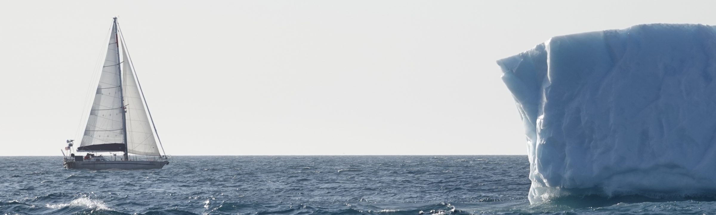
Winds are on the nose all day but at not more than ten knots. What slows us is the rolling chop from higher winds further W. Still, I can’t complain. By late afternoon, we’ve come abreast of the Richardson Islands, which decorate the northeastern corner of Coronation Gulf.
There are but two known anchorages in this island group, and neither looks appealing. But the next stop is a full ten hours further on. So, I decide to do a bit of exploring.
The northeastern most island in the Richardson group, heavily indented with coves and bays, is my target; specifically, the crescent bay to the SE. I turn Mo in and we began a tricky entrance.
My pass in is S of the two islands below Point Murray but above the line of rocks strung to the SW. The landform of the first island provides a hint–long sloping sides of smooth rock. And sure enough, as we passed below it, depth rises quickly from over 100 feet to twenty. I slow Mo to a crawl. Touching bottom in a muddy bay is one thing, but grounding on a rock outcrop when one is beyond help is quite another. The depths ease. Same phenomenon above the string of rocks. Again depths ease.
Once inside, depths stay deep and then shallow gradually as we make a wide turn around another spray of rocks at the bay’s entrance. Here water shallows, but the bottom contour changes so gradually as to be almost flat for a long run.
When the sounder reads twenty feet, I let go the hook. As it’s calm, I back down hard. Mo sticks immediately.
I call it Disappointment Harbor only because it’s a little too shallow for Mo to tuck all the way in and a little too big to be a convenient all-weather stop. That said, it is entirely closed-off from Coronation Gulf, and would be an ideal spot in anything less than a hurricane.
—

DISAPPOINTMENT HARBOR 68 35 041N 110 27 101W
Disappointment Harbor can be found in the Richardson Island group along the north shore of Coronation Gulf. It is situated inside a crescent bay on the SE side of the most northerly large island.
APPROACH
There are two passes into Disappointment Harbor. One is *south* of the two islands below Murray Point but above the string of rocks further south. This pass is approached from just south of east. Least depths are 20 feet below the first island and again just above the most northerly rock. This pass has only one sounding. Exercise extreme caution.
A second, safer pass is to the SW where a vessel can enter between the rocks and the islands in deep water, following a route to the NE that keeps the islands close to port.
The harbor is decorated with a grouping of rocks on its SE corner. These should be given a wide berth when entering.
ANCHORAGE
Disappointment Harbor is fully enclosed and offers complete protection from Coronation Gulf. Water shallows gradually to 20 feet about mid bay where anchorage can be taken in mud and excellent holding. As the bay is large, a vessel might favor the windward headland in strong winds to avoid fetch.
ICE CHARACTERISTICS
Unknown.
KATABATIC POTENTIAL
Unknown. There are low, tabletop mountains to the W and N that may affect wind in the anchorage, though neither range is close.


August 26, 2019
Total Miles: 34,464
Days at Sea: 269
Days since Departure: 331

The forecast calls for SW20, but the wind is highly dynamic all day, light to the Finlayson Islands, strong enough and far enough S thereafter to sail close hauled for a few hours, then light again as the day waned.
In the night and as we made approach to Byron Bay, a large thunderhead formed in the SW. It poured so much rain that the water top turned white. Mo got a drencher for ten minutes and then had to claw through very stiff SW winds for another ten.
The squall, something I’ve never seen in the Arctic before, seemed entirely out of place, like spotting a giraffe on the near headland. And so slow moving. An hour after anchoring, the towering black cloud was still making its unhurried way to the N. I thought I could see lightning over Victoria Island.
Byron Bay is a crescent shaped indentation in the coast 75 miles W and N of Cambridge Bay. It has good holding in 25ft black and red mud at 68 55N 108 30W. Good protection from N – SW. Open S – E. A gradual slope of the bottom from the beach means keel boats will anchor as much as a quarter mile off. Arctic Tern anchored here in 2014 to escape 40 knot W winds. For Mo, winds were SW15, and the anchorage was very comfortable.

Here only for sleep. We departed before breakfast for Edinburgh Island in Coronation Sound. We’re nibbling at our westing and waiting for the day when wind will go into a quarter not unremittingly dead ahead.
—
The terrain here is low and dreary, reddish dirt with as much differentiation mile after mile as that between infield and pitchers mound. Up close, the hills look neatly swept clean of life. Nothing sticks up higher than a medium sized rock. I think somewhere a giant groundsman is dragging his chain link fence across the land, readying the entire Arctic for the words, “Play ball!”


August 25, 2019
Cambridge Bay
Nunavut

Sunday morning. I am kick-the-dog frustrated. Wind is still hard and cold from the SW, day after day, relentlessly the wrong way, pinning us down in Cambridge Bay. And it is the same for as far out as the forecasts care to predict. How can we get home in such a wind?
From the cockpit, I can see a lone wooden platform on the beach near the tank farm, the cradle in which this boat stood the winter of 2014/15, now old and gray as driftwood. It’s a sign, I think, inviting Mo’s return. But I resent it deeply. I do not wish to spend a winter in Cambridge Bay. The injustice of it, to be stopped less than 4,000 miles from our goal. Lacking a dog, I slam my hand on the table. It aches for an hour.
—
At noon I move the boat downwind of the tank farm so as to make the ferrying of fuel from the beach a less wet exercise. I am to meet Miale, the wife of yesterday’s taxi driver, at 12:45pm. She will bring my jerry cans for tank farm pumps that open at 1pm. I dinghy ashore at 12:30. Promptly, Miale arrives at 12:45.
“Are the pumps open yet?” she asks, even though it’s clear we are alone.
The wind is chill. Miale wears the hood of her purple jacket up. I pull my wool cap down and over my ears. We step behind the pump shed to wait out of the gusts.
Miale is Inuit, a Baffin Islander, born near Iqaluit. She might just be five feet tall and looks far too young to be the mother of four. She is quiet without being diffident. Her black eyes sparkle when she smiles.
Having been in Cambridge Bay but 19 years, she considers herself new to the area.
“I can’t get used to how flat it is,” she says. “Baffin is all mountains. And because it’s flat, we get more wind. It makes the winters colder. Fifty below is normal. We have no sun for eight weeks, and when it’s dark, we just stay inside. The winters are very long.”
Miale’s English is perfect, and I learn that she went to university in Nova Scotia. “Pretty common,” she says. Miale works for the government as a court clerk. As Nunavut villages are too small to need a full time court, the judge and his administration travel. Miale is often on the road.
In Cambridge Bay, she met her husband, Cory, most definitely a white guy.
I ask, “what’s the ratio of white … ?” I pause.
“You mean non-Inuit? In Cambridge Bay it’s about 20%. In smaller villages there might not be any non-Inuit at all. We call you _______.” She says the word. I attempt to repeat it. Twice I have her say the word, but it is no good. To a white guy, the Inuit language is unpronounceable.
“Don’t feel bad,” says Miale, “I can’t speak the local dialect, and I can only understand the basics.” Each hamlet in Nunavut, all twenty two of them, has it’s own distinct dialect. “This one is more closely related to the Inuit of Alaska,” she says.
As we wait, I learn that this hamlet of 2,000 people is supplied by two barges a year, one with fuel (the tank farm holds a two-years’ capacity in case the barge is turned back by ice) and one with general supplies. Food, clothing, housewares, tools, phones, computers, hunting and fishing gear all arrive on this second barge.
“It’s like Christmas,” says Miale. “Suddenly the stores [there are two] are full. The prices go down, and we have a nice selection of canned goods.”
I relate, laughingly, that in the hamlet of Gjoa Haven I once found, on a nearly empty shelf, a can of peaches priced at $12. To Miale, this is as funny as a flat tire.
By now it’s 1:30. A line of cars and trucks has formed, all waiting for the tank farm pumps to open.
“It’s a new company running fuel distribution. We had hoped for better service,” says Miale.
At 1:45 a white pickup arrives with the fuel attendant for the day.
“My goodness,” he says,” I didn’t expect it to be so busy.
“At 1pm, it wasn’t busy,” says Miale.
—
Now fuel is aboard. Tanks are full and so are the jerries.
In the evening, I go into town for pleasure for the first time in five days. Pablo Primero of Mandragore (his lone crew member is also a Pablo, hence the title) has invited the crew of Moli and Alioth to a pizza dinner aboard. Mandragore is moored to the quay. As we jump down into her cockpit, we are asked to de-boot, and Pablo hands each of us slippers to wear in the cabin. Outside the wind still blasts. Inside the heater is roaring. There are five, homemade pizzas already laid out on the large dining table. Pineapple, salame, onion and garlic, smoked tuna, gorgonzola. There is a can of cold beer set before each place. Pablo Primero is prepared.
Soon the conversation warms up. Pablo Secundo, we learn, has spent the day defending Mandragore from the parade of hamlet children. Each asks to come aboard for a tour. Pablo Secundo politely declines; the children politely listen. And then they ask again. Then they go away to ride bikes for awhile. When they return, if Pablo is not in the cockpit, the children throw pebbles onto the deck to get his attention. “Hey mister, is this your boat? Can we come aboard?”
Vincent of Alioth announces that he may have sourced the gear box part needed to get his vessel on the move again. There is a toast!
Then Randall says that he will be underway in the morning.
“But the wind, it is so strong,” says Pablo Primero.
—
All night the wind makes its white noise sound in the rigging. But in the morning, it is very light from the SW. Mo’s chain goes straight down. I weigh anchor at 8am and slip quietly out of the bay.


August 24, 2019
Cambridge Bay
Nunavut

The blow blew itself out overnight, but weather has continued to be unsettled. Today, strong winds from the SE, rain and a heavy, ragged cloud. In the morning I shifted Mo to the pier in town for fuel only to find the wind increasing still and the pier foaming with chop.
Thinking I could dinghy in for fuel, I anchored near town and just off where Amundsen’s Maud came to rest so many years ago. But the berth was too small, and it felt unwise to leave the boat in such blustery conditions.
So, back we went to our original anchorage in the W Arm. Down came the dinghy and from there I motored with jerry cans to the tank farm. No one there. I hiked to the airport and called a cab.
“Where can I fill diesel?” I asked the driver.
“At the tank farm,” he said. “They’re open till five.”
“I was just here; no one home.”
“So no problem, we’ll go to the filling station in town.”
—
“No diesel here,” said the attendant.
“Wait, you don’t sell diesel at the filling station?” I asked.
“Not since a water truck took out the pump last year. Go to the tank farm. They’re open till five.”
—
“Can we get there before they close?” I asked.
“Not a problem,” said the driver, stepping on it.
We pulled up at the tank farm at 4:50pm. A sign on the door read, “Closed all day due to technical difficulties.”
—
Back at the boat, I attempted to salvage a lost day by doing an oil and filter change. Now, except for fuel, we are ready for the next leg.
—
But the weather forecasts continue to be contrary. SW and W winds, often strong, all the way into the future and all the way to Point Barrow. I really don’t know how we will get there in time.
August 23, 2019
Cambridge Bay, Nunavut
69 06N 105 09W

Sitting out a gale at anchor is not the same as riding out a gale at sea. In the former case, one is moored in a secure harbor as the storm rolls over, and in the latter, he is being swept along with the forces of nature like a butterfly on an afternoon breeze. But which is safer is an open question.
The adage that contains “any port in a storm” would suggest that given his druthers, a sailor would choose safe haven over running off every time. But this cannot be so. If Mo had encountered this blow well offshore, a blow that at its height has seen 40 knot winds, she would have had a couple of screaming 180 mile days with a deeply reefed headsail, and everyone would have been happy, if somewhat sleep deprived.
What made me so ardently seek the shelter of Cambridge Bay for this blow was not the forecast winds but our proximity to land when those winds arrived. Being in the Arctic archipelago means one cannot simply run off. Here there are rocks, islands, and even ice to threaten one’s way. Everything is lee.

But anchoring is not all bliss, either. Now, instead of betting on the seaworthiness of the boat, you are betting on the strength of the ground tackle. The boat has stopped being a storm riding machine; in harbor, she is simply a hulk tied to a length of chain, upon which all depends.
—
Our gale came on during the night as foretold. By morning, winds were 30 from the W and the sky, low and menacing. By noon, we’d been overtaken by a cold, driving rain that hardened the wind. Now Mo heeled well over in the gusts and threatened to spill my coffee. Even with shore but a quarter mile to windward, a three foot chop developed. The small whitecaps had their tops blown off and trailed spume. Mo threw spray back on deck. The whole boat vibrated.
During this I could not help but contemplate the soundness of my ground tackle choices. Here is where they would pay or not.
—
Mo’s anchor is the SPADE type, a worthy design, but the chain that connects it to the boat does not immediately fill one with confidence. At 8mm (5/16ths), it is a full size smaller than what I expected to find when I did the initial purchase survey, and it took some time to figure out why the previous owners had made such a choice.
All chain is not created equal, and in this case, the chain that filled the anchor locker was of the highest tensile strength available, known as G7. Using this smaller diameter but higher strength chain (rather than 10mm of the more common and less expensive G4 chain) allows Mo to carry more length of chain (in this case, over 400 feet) for the same weight in the bow. More chain equals more deep water anchoring options. A smart move.
—
The working load limit of this chain is 4,700 pounds. Is that enough to keep a 35,000 pound Moli secured in a gale?
It is a question of paramount importance, and yet finding any data on this topic (as opposed to advice, of which there is plenty) is a challenge. Only one reference have I found, an offhand remark by Steve Dashew in his Encyclopedia: “Our fifty foot boat might generate 2,000 pounds of load in 50 or 60 knots of wind.” How he got to this number is not explained.
Today in email I received an article on this topic written by Don Jordan, the designer of the Jordan Series Drogue.* The article’s focus is the safety of mooring a boat by the stern rather than the bow in extreme weather, but it contains the following illumination:
“Fortunately, very complete data on the aerodynamic drag of all reasonable objects are available from testing in wind tunnels and other facilities. Under these conditions [60 – 75mph winds], the drag of the hull [of a modern 40 foot boat]…will be about 300 to 400 pounds, and the drag of the mast and rigging will be 700 to 800 pounds. We might use a conservative estimate of 2,000 pounds for design purposes. [By comparison,] the breaking strength of a 3/4-inch nylon mooring line is 16,000 pounds.”
Data! What a comfort. And amazingly, it correlates with Dashew’s remark. So it appears that, baring shock loads, (accommodated for in this gale by 30 feet of nylon line), Mo’s ground tackle is more than sufficient to the task of keeping boat and skipper safe.
—
6pm. The height of the blow is past. Rain has transitioned to puffy cumulus clouds and the barometer pushes above 1000mb. Tomorrow we fuel in town; change oil and filters, and then we are back on the Northwest Passage course.

Fewer than 4,000 miles to home.
*http://www.jordanseriesdrogue.com/pdf/AnchorJordan52006.pdf
August 22, 2019

Mo with Alioth in tow rounded the corner into Cambridge Bay at 11pm last night. Alioth came to anchor over a forty foot shelf in the bay’s West Arm, and Mo took a berth a few hundred feet further on. Another consort to Alioth, Mandragore, also took shelter nearby.

Shelter. Because change is coming.
The barometer has been falling slowly but without hesitation for three days. It’s high was 1024mb, and as I type, it reads 985.5mb with no sign of finding bottom. By way of suggesting that such a fall must presage apocalypse, the ice guide, Victor Wejer, sent out a general blast to local boats earlier today. “Sub 970 low over Canadian Arctic by Friday afternoon is in record territory. Expect storm and major meltdown,” he wrote.
So, I’m relieved to be successfully done with the tow but am more relieved that we did it. Now we have a chance at safety.
After anchoring, all were invited to an arrival celebration dinner aboard Alioth that got started at midnight and ended after 3am. I slept until nearly noon.
The three boats have spent the day preparing for the coming blow. Alioth put out two anchors. Mo will ride to one but with very long scope and a long, elastic snubber. I’ve also rigged the second anchor to a coil of spare rope road which can be dropped over the side if the first anchor goes on holiday.
What can be done has been. Now for some sleep. The fun should commence at midnight.
August 21, 2019

This log is out of order because I can’t keep up given current happenings. So, a short update now and a more thorough report in coming days.
Mo and I are still closing The Crux of the Matter chapter by an entry into Cambridge Bay. Here awaiting us are a few nights of consistent sleep, the replenishment of our fuel supplies, and hopefully a stroll through town.
Sadly, hamlets in Arctic Canada contains no brew pubs, and though Cambridge Bay has taken a large step toward metropolitanization by the installation of two restaurants, the last I was here, its Kentucky Fried Chicken was out of chicken and the Pizza Hut had run out of dough. Recall that these communities survive largely on the supply from one barge a year, which arrives in late summer, often after the seafaring tourist has come and gone.
We have been in company with Alioth since our Larsen Sound in-the-ice rendezvous. After exiting the last floes, we sailed due S towards the Clarence Islands so as to avoid an ice tongue stretching E from the McClintock Channel. Then we turned toward Icebreaker Channel, which separates Jenny Lind Island and the larger Victoria Island.
Sailing has been good until last night when wind died and the sea became greasy smooth.
Certainly a sailboat can wait for a breeze, but in this case, we were faced with the prospect of strong heading winds from the S by morning followed by gale force winds from the SW if we couldn’t find a way under Victoria Island in a hurry.
So, after supper yesterday, Mo and her little red engine took big Alioth under tow. All night we made good if slow way to the S, and when S winds filled mid morning, we were in position to take them as an easy reach to the W.
As is their wont in these parts, winds gave out in the afternoon. Now Alioth is under tow again, but we are a mere two hours from port.
The change in the land form here is stunning. Greenland, Bylot and Baffin Islands consist of sharp snowcapped mountains spilling glaciers, and the desert mesas of Devon Island, though low, are regal, imposing and bring to mind ancient days. But here, in this part of the Arctic, the land is…..just…..flat.

Aug 16th
4:30am
Underway from Graham Harbor

All day the sea birds are flying the other way. They are headed out of the ice maze, out into Lancaster, back into Baffin and south. Winter migration has begun. All the while, Mo pushes further into the heart of it.
Last evening’s ice charts show improved conditions. Above Bellot, the ice is about 3/10ths for long stretches, but below there’s still a tongue of 7/10ths above Tasmania Islands.
And then there’s the difference between the report and actual. Alioth is a day ahead of Mo by now, and Vincent reports, “We just spent 12 hours finding our way through at times very dense ice (probably 5/10ths) from Hummock Point to Hurditch Peninsula.” I measure it off: 12 hours to go 40 miles.
“You must consider to sleep in 20-minute shifts for every four hours of steering,” wrote Vincent. “Keep moving. The sun also shines below Bellot Strait.”
At midnight that shining sun is still above the horizon, but I am pooped. We’ve been underway from Graham for 20 hours, and there is always a white chunk or two on the horizon; now an hour in the bunk is too long. Given the difficulties of the next 150 miles, I decide to take one last, long sleep.
Off Cape Swansea at the top of Peel Sound, I heave to and shut down the engine. Mo drifts slowly N. I crawl into the sleeping bag. But it is no good. I am up every hour. At 4am, I rise. By 5am we are underway for our engagement with the ice.
Aug 17th
Underway from Cape Swansea
Clear and calm. As we motor hour after hour, each notation in the wind column of the log reads simply, zero. The sun is bright and warm. In the cockpit, temperatures are in the 50s. After breakfast, I set about chores. The fuel tanks are topped off from jerry cans, and at the transom, both the hydrogenerator and Monte’s water paddle are removed. Either could be damaged easily if we are nipped by ice.
By 11am we are across Aston Bay and it has been open water. In any case, I don’t expect ice here.
Noon, still open water.
Half an hour later, we are moving through 2/10ths ice off of McClure Bay. I start hand steering. It is easy going. Though beautiful, the ice is rotten, the pieces are small and much eaten away. I weave Mo at full speed as I keep an eye forward for more.
Only once do I screw up. I aim to pass between two small floes but fail to see the diagnostic light green between them. They are one floe connected by an underwater bridge. But it is too late. There is a clinking sound much like the jostling of ice cubes in a glass. Mo thunks. And the floes drift apart.
Off Hummock point, ice thins out but two hours later I begin to see solid white on the horizon. The day’s mirage picks up this image and makes it look like a tidal wave of white rolling towards us. Now we are in it, solid 5/10ths ice. Still, with care and concentration I am always able to find a lane just when it is needed. We weave back and forth; I am pulling on the tiller as though it were the handle of an oar. It is exhilarating. And still we are at full speed.
Ice goes thin then thick then thin again. Hours pass and I am still working the tiller.
What has been heavy going begins to thin at 11pm. The water is clear enough that my course changes are mere nudges of the tiller. I play the dangerous game: how little can you change course; how close to the ice can you get? Only sometimes do I miss, proof being the thud on the hull and a smudge of black on the ice.
Midnight. The sun is down. The aspect is of late evening. It is a struggle to see. Luckily now the floe is but odds and ends. I have been hand steering for nearly twelve hours and can feel the fatigue in my leaden eyes. My thighs feel shaky.
In the dusk ahead I see a long, dark opening. There is white further on but it must be a whole ten minutes distant. I flip on the autopilot, drop below, and set the alarm for a five minute nap. I collapse against a bulkhead; am immediately asleep.
On the fourth minute there is a heavy crashing sound. Mo shudders as if hitting a wall. She stops dead. The engine grids right down. I leap for the throttle and back her off and then look forward. There Mo and ice the size of a car are drifting as if dazed. But the ice block has been split in two.
At 2am we are below the ice. Yes, there’s a bit here and there, but we’ve got past our first big plug. A sense of satisfaction. New territory, and we have managed. Maybe we can do this after all.
On we sail south. On and on. Finally there is that cut into the land, False Strait. I ease Mo in and drop anchor at 6am. We’ve come 150 miles in 23 hours and passed our first of three ice gates. Bellot Strait is but one mile S. Below it begins Franklin Strait. Above is Peel. We are through Peel.


August 19, 2019
1845 local
70 32S 97 27W
Larsen Sound
The Arctic

Just a quick note to report that Mo is through the ice and sailing fast on a N wind for Cambridge Bay, 235 miles SW.
I have been pushing to get to Alioth’s position for two days. She has a busted gear box and can’t make more than three knots under power. She has been hove to at the head of our last major ice plug waiting for an escort as she’d have to sail through, a tricky business.
We’ve all been sweating bullets over this last 30 miles of ice, and for four days I’ve been underway and hand steering for 18 to 20 hours a day through 3 – 5/10ths ice to get here. Only a few hours sleep a night this last week.
As it turns out, today was a piece of cake. We saw huge ice floes the size of city blocks but with wide lanes in between. Alioth and another boat, Mandregore, sailed downwind without trouble with Mo bringing up the rear under power just in case.
We got underway at 2pm and by 6:30pm we were in open water.
One big chapter in the Figure 8 is closed. One long chapter, the 4,000 mile slog home, remains.
Huge thanks to Victor Wejer, our ice guide, for his help and tough-love encouragement these last days. Victor was awake and communicating at all hours of the day–weather in the morning, ice charts in the afternoon and pep talks at 3am. It was a great pleasure to have Victor at my back!
The story will out and so will lots of photos but not today. Today, a beer and some sleep while Mo flies S toward Clarence Islands and around the last ice tongue; then we gybe SW for Cambridge Bay and onward toward home!
Hello fabulous followers of the Figure 8 Voyage.

If you’ve been following the voyage you’ll know that Mo and Randall are currently navigating a pretty tricky portion of the North West Passage. Like you, we’re all holding our breath here a little. Randall won’t be posting today as we want him watching for bergs and navigating so you’re going to hear from us.
Couple of quick updates:
VIDEO INTERVIEW WITH RANDALL
If you’d like to watch an interview Randall made with another adventurer Greg Horner. Taken while Randall was up in St. John’s Newfoundland take a look below.
THE RETURN UNDER GOLDEN GATE BRIDGE
Also, we’re trying not to be too premature but we’re starting to get organized for Mo and Randall’s sail under the Golden Gate Bridge.
As we have over 2,000 daily readers from around the globe (thank you!) on the website, Facebook, Twitter and Sailfeed, just to name a few. We thought some of you might want to join us in welcoming Moli and Randall as they come under the bridge. To keep communications simple we’re asking you to tell us if you’d like to be on the communication list. To do this we have some questions and want you to register here. Please do not comment on the blog, social posts etc as we will not be capturing names from here. We will post information but if you want to get invited to stuff we need to know who you are. We’re a tiny and scrappy team behind the scenes at the Figure 8 Voyage help us, help you.
We’ll be sharing this again when we have more information but the sooner you register the better. We have no logistics yet other than to share that at some point Jo will be standing waving madly at a tiny boat coming in from the sea.
Here’s the link again: https://theamplifylab.typeform.com/to/McVcwc
August 16, 2019
Days at Sea: 262
Days Since Departure: 320
Noon Position: 74 20N 90 54W
Course(t)/Speed(kts): WxS 6.5
Wind(t/tws): –
Sea(t/ft): –
Sky/10ths Cover: Clear 0
Bar(mb): 1015, steady
On-deck Temp(f): 57
Cabin Temp(f): 68
Water Temp(f): 35 (note water temp is steadily dropping.)
Relative Humidity(%): 36
Magnetic Variation: -25./3
Sail: Under power with double reefed main as steadying sail
Noon-to-Noon Miles Made Good (nm): 45 from Graham
Miles since departure: 33,948
Miles to Gjoa Haven: 590

In bed by 11pm. Alarm set for 4am. Awake by 3am, wide-eyed. Underway for Peel Sound.
—
Over the last few days, charts have shown a significant reduction in ice concentrations in Peel, but there is still ice, lots of ice. One hundred miles into the Sound from the N, there is a band of 4-6/10ths ice that is sixty-five miles long and covers both the eastern and western shores. Another one hundred miles below that is a large band of 1-3/10ths ice. Below that there is open water, but it is threatened by the heavy ice feeding in from M’Clintock Channel.
Add to this an imminent change in the weather. Long range forecasts are calling for a switch from these long-running E winds to SW winds and then strong southerlies that could scramble the current ice configuration.
Add to this a paucity of anchorages in Peel. Two of the best on the W coast are icebound. The next, False Strait, is just above Bellot Strait and 165 miles from the opening.
—
In the evening I reach out to the ice guide, Victor Wejer, for a consult on anchorages. Mo needs a place to hide if things go badly. I show him the areas I’ve chosen.
“This is a subject I would like to avoid,” he replies. “It is not written in stone that you must take the entirety of Peel in one go, but it is the usual way. Read the Canadian Sailing Directions. The height of Somerset Island does weird things to the wind; it can go from calm to gale in an instant. Most of what look like anchorages on the chart are just not safe.”
“As to ice,” he continues, “this is also difficult. Peel is narrow and fed from M’Clintock. Most sailboat crews fight tooth and ice pole to get through. Consider that Matt Rutherford chose Prince Regent. But for you there may not be an option. Regent will not be clear for a long time; maybe not at all this year.”
By now four boats are through Peel, below Bellot Strait and on their way to Gjoa Haven. Yellow-hulled Breskell is one of them, but it has taken her four days to transit 200 miles, and I can tell from the way Olivier writes his encouraging emails that he has his doubts about doing it solo.
“Not many have singlehanded the Northwest Passage,” closes Victor, “Take your difficult bite; be brave, and exercise your anchor alarm if you do stop.”
—
Tillman talks about the salubrious affects of fear, but like many tonics, it tastes bad going down. In the South we were following the wind, at least. Here, even at the height of things, Mo was in her groove, and if a particular low was hell on wheels, I just had to keep my bird floating and hang on. Eventually an Ushuaia or a Hobart would hove into view.
Here we are decidedly pushing against the flow, a flow with hard, pointy teeth that has not met its match in boats this small. It may or may not spit us out the other side.
—
I recall Willie DeRoos’s remarks when his Williwaw became trapped in Arctic ice. DeRoos was the first to transit the Northwest Passage in a yacht, this back in 1975. As the ice slowly came down on Williwaw and surrounded her, DeRoos’s crewman, standing lookout at the bow, turned to search aft for an escape route. Willie roared from the cockpit, “there is no going back, there is only forward.”
—
As I type, we are 30 miles from the entrance. Currently I plan to keep going until late, to grab as many miles as I can today and then heave to for a few hours when the sun sets (it does set now). I’d like to be at the ice edge by tomorrow afternoon.
—
In the morning, we meet our first pack ice of this transit off Maxwell Bay, a ribbon of rotting ice left over from a losing battle with the warmth of Lancaster Sound.


August 15, 2019
Days at Sea: 261
Days Since Departure: 319
Noon Position: 74 27N 85 02W
Course(t)/Speed(kts): W 6.5
Wind(t/tws): 0
Sea(t/ft): 0
Sky/10ths Cover: Clear/0
Bar(mb): 1014, steady
On-deck Temp(f): 60
Cabin Temp(f): 63
Water Temp(f): 38
Relative Humidity(%): 43
Magnetic Variation: -34.4

Sail: Motoring under double reefed main
Noon-to-Noon Miles Made Good (nm): 42 since departing Dundas
Miles since departure: 33,850
Anchor down Dundas Harbor by 9:30pm after a brisk, glorious beam reach across Lancaster. What joy, to sail! Mo makes a frothy eight knots while passing alabaster mountains, great bergs pushing their way up the sound. When the wind eases, I raise more sail and the boat makes a frothy seven knots. Her movement is sure and purposeful. Magically now she is a flying horse instead of a plodding motorhome, and it is as though I am experiencing this thrill for the first time.
The only hiccup is the chart plotter’s loss of compass heading mid channel. Compass heading, not course over the ground, is what gives the autopilot its sense of direction and is a thing the system must have to operate. On Mo, this information is gathered from a GPS compass mounted on the radar arch. When heading fails, alarms sound, the autopilot shuts down, and Mo goes wildly off course.
In a flash, Monte takes over pilotage, and I spend the remainder of the passage sorting things out.
For a time in the Southern Ocean, heading loss was sporadic, and I then (inconclusively) linked the issue to use of the radar. But both radar and, now, autopilot have been in constant employ since Halifax without a hitch. A panic begins to uncoil in my gut. No heading sense, no autopilot; immediately I’m down to hand steering when under engine power. This sail across Lancaster under the deft hand of Monte is a fluke–up here it’s all engine.
I run some tests, reboot everything, do the unplug-replug dance. Problem repeats.
After a time, I realize that if I turn the radar off, heading comes right back, but how can that be? The electronics gear has been too reliable for too long for this to be gear failure. This has to be connection, charge related…and suddenly it clicks. The problem only happens when the engine is off (i.e. not charging) and when electronics load on the batteries has been high for a period of time; thus, something in the heading sense system is susceptible to low voltage. (Note: two days later and we’ve motored 20 hours. Heading loss occurrences: zero).
–
Alioth, who departed Tay half an hour after Mo, arrives Dundas half an hour before. Much of the crossing she was well in view, a beautiful, fast ship. Her crew are already hiking to the abandoned RCMP shack by the time I am secured and the stove lit. I make a quick dinner and am asleep before 11pm.
Alarm set for 6am. Awake at 4am and too nervous to continue sleeping. Underway by 5am for Graham Harbor, 95 miles down Devon Island.
Save for Mo, Dundas is empty when I take my bearings. Alioth has departed at some unknown hour. A slight feeling of emptiness. Isolation. Cruising in company is fun. But the fact is that each boat up here is alone, must make its own way, make its own decisions, solve its own problems. Alioth’s unannounced departure is like an admission of truth. A surprise break up everyone saw coming.
The leg to Graham is, again, uneventful. All motoring on a glassy sea. By 8pm, Mo is anchor down in 50 feet on a rock, mud and kelp bottom. The cliffs are high and close-in and have reversed the light easterly outside to a sharp SW wind inside. The bay is small, the bottom steep and holding unsure. Here and there a derelict bergy bit roams the place looking for trouble. I am at Graham for a quick sleep, and it is hard won. Pack ice is close now, a mere 200 miles E and S in Peel Sound. I can feel its churn and grind. Things are coming to a head. This next week will tell…


Aug 14, 2014
Tay Bay

“Travel in the Arctic takes great patience and great determination,” said Tony Gooch in a recent note. Presuming those two qualities are applied at different moments of a journey, then it’s patience I need now. I itch to be moving. There are still so many miles.
But Lancaster Sound blows a gale today. So, at calm and quiet Tay we stay.
We are at the back of the pack now. One boat, Inook, is already S of Bellot Strait; my friends on yellow-hulled Breskell are in Peel Sound with Altego and Morgane and maybe others. Alioth is in Tay with us. Only two boats I know of have yet to enter the Arctic: Sedna, a father/daughter team who are attempting to sail this entire route without engine power and Mirabelle, last seen in Sisimiut with engine problems.


What are the chances a departure today would encounter anything but a few icebergs in a crossing to Devon? Small. But in such a wind, pack ice would be a lee shore. Why risk it when that risk is not absolutely necessary? This is not a race. Mo and I have come too far to play silly buggers with ice if we don’t have to.
And we don’t. We aren’t late.
Compare Les and Ali Parson’s Arctic Tern, the vessel on which I crewed the NWP in 2014. It was a difficult ice year, and we didn’t depart Arctic Bay, just west of Tay Bay, until the 16th of August. On the 21st, we finally weighed anchor from Devon Island’s Graham Harbor and began heading S. We didn’t make Fort Ross until a week later, August 26. We exited Bellot on the W side on August 29.
Granted, that was pushing it, and the earlier I can arrive in The Bering and Alaska’s powerful gulf the better, but there is time.
And yet I itch to go.
“Prince Regent is closed,” wrote the ice guide, Victor Wejer, yesterday, “absolutely no chance it will open. Go direct Peel. Ice in Franklin and Larsen are dramatically improved.”
But I worry it could turn. A west wind could block further progress. What if the gate closes and I didn’t get through.
And yet… But wait…
On and on and on like this…

—
So in the afternoon I go for a hike to expend some energy. And that night, I am invited to dine with Vincent, Olivier and John aboard Alioth. Lasagne (imagine a baked lasagne!), red wine and stories flying. I get lathered up and am recalled to my duty only when I note all other plates but mine are empty, their owners quietly waiting a much desired pause before going in for seconds.

—
Aug 14, 2019
Underway from Tay at 10am to some place on Devon. Brisk wind in the channel. Mo makes 8 knots without trying as soon as I remember how to raise sail. Big, beautiful bergs. No pack ice. I think I’ll head to Dundas Harbor for tonight and be underway tl the west bright and early tomorrow.

Yes -it’s the same one. But this time with photos.
Aug 11, 2019
From Tay Bay
Bylot Island
73 29 6N 80 45 5W

Departed Hatt Trick Harbor at 9am after a few more surveys of depths in the arms. I wanted to explore the mountains, the back country, to sit on the bluff and watch the snowy peaks on Bylot change colors as the sun circled. But that’s for another adventure.
Next stop, Tay Bay, sixty miles up Navy Board Inlet.

For a time we sailed on E winds. And then we motor-sailed on W winds. But mostly Mo bashed into headwinds that increased and then were joined by fog. The last ten miles took three hours as I tacked up the channel under power. A few bergs. No pack ice. But I thought I could sense ice in Lancaster as the day darkened and went cold.
Anchor down in Tay behind the W bluff an hour before midnight. From a fuel perspective, it was an expensive sixty miles of hard driving.

Aug 12, 2019
From Tay Bay
The fine, long days have monkeyed with my sleep schedule as much as the travel. Back at Hatt Trick Harbor, my evening hike lasted until 1am, when the sun at last dipped behind the ranges to the N. At Tay, dinner was served at midnight, and I relaxed in the cockpit until the chill and the fog had crawled into bones. Now I never rise before eight o’clock.
The forecast calls for a gale in Lancaster today and tonight. Mo has seen plenty of gales and fears them not, but her skipper is wary. We would encounter nearly no pack ice (emphasis, nearly) as eastern Lancaster has been clear for some time. But searching for the rare bit of ice in eight foot seas hour after hour is all well and good when there is no choice, but today there is a choice. So here we have remained.
These are the decisions one frets over. To go or to stay. To risk a bashing in Lancaster or being one day too late at Point Barrow. All afternoon I’ve done chores and said I’ll depart next hour, after the next forecast, or the next. Only at 5pm, and after a note from Victor Wejer suggesting there was no profit in an advance now, have I put my foot down: the anchor shall remain dug in.
Having done that, I sat back to take the measure of this place.
The water here is the color of clay. When the fog obscured the mountains, this color was a mystery. But now we can see the mountains to the S; they are old, eroded giants, and they are fawn gray. Sharp, rust red peaks jut up from the water to the N, and at the head of the bay sits an inactive glacier.

Noticeably different is the wildlife. In Hatt Trick Harbor, there was none save two harassing gulls and one passerine I couldn’t identify. Here a gaggle of snow geese on the beach ran away in a panic as Mo’s chain rattled down. I’ve seen ducks and grebes in the air, a colony of glaucous gulls on the far bluff, and two seals patrolling the murky waters.
I have yet to see Alvah Simon’s raven, however. Simon (and, for a time, his wife) overwintered just yards from where Mo swings gently, a saga he chronicled in the thrilling book, NORTH TO THE NIGHT. One of his companions was a kitten named Halifax; the other was a raven that remained in the bay through the dark months, no doubt hoping Simon would err fatally and become carrion, which is to say, dinner.


It is difficult to imagine the change that will be required for this placid scene to become a blizzard-wracked deep freeze or how it would look in perpetual night. Only if I err myself will I find that out this year. Better get back to chores…
August 10, 2019
Yes -it’s the same one. But this time with photos.

Soon after departing Pond Inlet, Alioth and Mo become separated. Alioth is a sleek vessel with a lifting keel and a waterline length greater than Mo’s overall, which is to say she’s a knot faster without trying. And too, our agendas differ. Vincent wishes to sight the Narwals said to frequent the opening of Milne Inlet, and so for the night targets a cove on the back side of Ragged Island. I am more attracted to a little-explored bay just S and E of Cape Hatt.

Wind remains light from the E, and the 35 mile passage is uneventful, save for a heavier than expected chop at the head of the inlet that sets Mo to rolling like she was at sea again. Books, dishes, even a fuel can go flying. I’ve gotten too used to a level playing field in the miles and miles of calm since St John’s.

On my chart, the bay is nameless and without soundings, but the Pilots are cautiously optimistic. “…said to be a snug harbour,” reports the Canadian Sailing Directions. “…is navigable for small vessels. Depths vary throughout…caution should be exercised,” says Wilkes in ARCTIC AND NORTHERN WATERS.

What attracts me most is its shape. The N-facing entrance is long, narrow, and overlaps the bay entirely; the interior appears to have three arms, each with the possibility of being landlocked. As described before, a landlocked bay is often sheltered from all weathers. Here, once secured, a vessel can be safe always, a sailor can drop his guard.

I go dead slow down the fairway, favoring the E shore, where a chartlet provided by Vincent suggests is better water. Luckily we are at the bottom of the low. Least depths are 20 feet here and 50 feet middle bay. I gently explore each arm and find that the bottom rises slowly and evenly. There are no surprises. Finally, I ease Mo behind the N headland and anchor in 25 feet. The hook bites without a grumble.


With the engine off, I can admire my find in silence. All around, the landform–the eroded remains of high ranges to the N and S–slopes gently down to the beach. And all is indeed landlocked, profoundly landlocked. Here we feel not the tiniest hint of the rolling chop and crashing breakers outside. And from where Mo sits on the hook, I can’t see the entrance or even where one might be. It is as if we had been transported in an instant to a high desert lake.
Mo is motionless; the water is glass. The hills sit quietly by. Nothing moves, not a bird, not a bear.
An Inuit camp in the SE arm and an empty fuel barrel on a near beach suggest we are not the first humans to discover this gem. But as neither the charts nor the Pilots give this spot a name, I do: Hatt Trick Harbor, a nod to the northern Cape and the fact that this is really thee excellent anchorages in one.


Monte (MonTAY) is disgusted and refuses to speak to me the rest of the day.
Aug 11, 2019
From Tay Bay
Bylot Island
73 29 6N 80 45 5W

Departed Hatt Trick Harbor at 9am after a few more surveys of depths in the arms. I wanted to explore the mountains, the back country, to sit on the bluff and watch the snowy peaks on Bylot change colors as the sun circled. But that’s for another adventure.
Next stop, Tay Bay, sixty miles up Navy Board Inlet.
For a time we sailed on E winds. And then we motor-sailed on W winds. But mostly Mo bashed into headwinds that increased and then were joined by fog. The last ten miles took three hours as I tacked up the channel under power. A few bergs. No pack ice. But I thought I could sense ice in Lancaster as the day darkened and went cold.
Anchor down in Tay behind the W bluff an hour before midnight. From a fuel perspective, it was an expensive sixty miles of hard driving.
__
Aug 12, 2019
From Tay Bay
The fine, long days have monkeyed with my sleep schedule as much as the travel. Back at Hatt Trick Harbor, my evening hike lasted until 1am, when the sun at last dipped behind the ranges to the N. At Tay, dinner was served at midnight, and I relaxed in the cockpit until the chill and the fog had crawled into bones. Now I never rise before eight o’clock.
The forecast calls for a gale in Lancaster today and tonight. Mo has seen plenty of gales and fears them not, but her skipper is wary. We would encounter nearly no pack ice (emphasis, nearly) as eastern Lancaster has been clear for some time. But searching for the rare bit of ice in eight foot seas hour after hour is all well and good when there is no choice, but today there is a choice. So here we have remained.
These are the decisions one frets over. To go or to stay. To risk a bashing in Lancaster or being one day too late at Point Barrow. All afternoon I’ve done chores and said I’ll depart next hour, after the next forecast, or the next. Only at 5pm, and after a note from Victor Wejer suggesting there was no profit in an advance now, have I put my foot down: the anchor shall remain dug in.
Having done that, I sat back to take the measure of this place.
The water here is the color of clay. When the fog obscured the mountains, this color was a mystery. But now we can see the mountains to the S; they are old, eroded giants, and they are fawn gray. Sharp, rust red peaks jut up from the water to the N, and at the head of the bay sits an inactive glacier.
Noticeably different is the wildlife. In Hatt Trick Harbor, there was none save two harassing gulls and one passerine I couldn’t identify. Here a gaggle of snow geese on the beach ran away in a panic as Mo’s chain rattled down. I’ve seen ducks and grebes in the air, a colony of glaucous gulls on the far bluff, and two seals patrolling the murky waters.
I have yet to see Alvah Simon’s raven, however. Simon (and, for a time, his wife) overwintered just yards from where Mo swings gently, a saga he chronicled in the thrilling book, NORTH TO THE NIGHT. One of his companions was a kitten named Halifax; the other was a raven that remained in the bay through the dark months, no doubt hoping Simon would err fatally and become carrion, which is to say, dinner.
It is difficult to imagine the change that will be required for this placid scene to become a blizzard-wracked deep freeze or how it would look in perpetual night. Only if I err myself will I find that out this year. Better get back to chores…
August 10, 2019

Soon after departing Pond Inlet, Alioth and Mo become separated. Alioth is a sleek vessel with a lifting keel and a waterline length greater than Mo’s overall, which is to say she’s a knot faster without trying. And too, our agendas differ. Vincent wishes to sight the Narwals said to frequent the opening of Milne Inlet, and so for the night targets a cove on the back side of Ragged Island. I am more attracted to a little-explored bay just S and E of Cape Hatt.
Wind remains light from the E, and the 35 mile passage is uneventful, save for a heavier than expected chop at the head of the inlet that sets Mo to rolling like she was at sea again. Books, dishes, even a fuel can go flying. I’ve gotten too used to a level playing field in the miles and miles of calm since St John’s.
On my chart, the bay is nameless and without soundings, but the Pilots are cautiously optimistic. “…said to be a snug harbour,” reports the Canadian Sailing Directions. “…is navigable for small vessels. Depths vary throughout…caution should be exercised,” says Wilkes in ARCTIC AND NORTHERN WATERS.
What attracts me most is its shape. The N-facing entrance is long, narrow, and overlaps the bay entirely; the interior appears to have three arms, each with the possibility of being landlocked. As described before, a landlocked bay is often sheltered from all weathers. Here, once secured, a vessel can be safe always, a sailor can drop his guard.
I go dead slow down the fairway, favoring the E shore, where a chartlet provided by Vincent suggests is better water. Luckily we are at the bottom of the low. Least depths are 20 feet here and 50 feet middle bay. I gently explore each arm and find that the bottom rises slowly and evenly. There are no surprises. Finally, I ease Mo behind the N headland and anchor in 25 feet. The hook bites without a grumble.
With the engine off, I can admire my find in silence. All around, the landform–the eroded remains of high ranges to the N and S–slopes gently down to the beach. And all is indeed landlocked, profoundly landlocked. Here we feel not the tiniest hint of the rolling chop and crashing breakers outside. And from where Mo sits on the hook, I can’t see the entrance or even where one might be. It is as if we had been transported in an instant to a high desert lake.
Mo is motionless; the water is glass. The hills sit quietly by. Nothing moves, not a bird, not a bear.
An Inuit camp in the SE arm and an empty fuel barrel on a near beach suggest we are not the first humans to discover this gem. But as neither the charts nor the Pilots give this spot a name, I do: Hatt Trick Harbor, a nod to the northern Cape and the fact that this is really thee excellent anchorages in one.
Monte (MonTAY) is disgusted and refuses to speak to me the rest of the day.
August 9, 2019
Days at Sea: 257
Days Since Departure: 313
Noon Position: 72 46N 77 26W
Course(t)/Speed(kts): W 6.6
Wind(t/tws): S 7
Sea(t/ft): —
Sky/10ths Cover: Fog and clear sky 4
Bar(mb): 1022
On-deck Temp(f): 58
Cabin Temp(f): 64
Water Temp(f): 45
Relative Humidity(%): 53
Magnetic Variation: -35.1
Sail: Under power.
Noon-to-Noon Miles Made Good (nm): 155
Miles since departure: 33,633
Miles to Pond Inlet: 10

Near midnight the fog dropped its guard, allowing a view of the ranges of Baffin and Bylot Islands on a distant, sun-drenched horizon. Soon we were on the verge of sailing into the clear ourselves when the wind came up lightly from the S and brought that infernal gray blanket with it. This covered us completely and until the customary hour off shore.
Then the mountains came out for real and for good.


Bylot Island, snow capped and ribboned with glaciers, was the focus of H. W. Tillman’s summer adventure of 1963. It was chosen due to its being “difficult to reach, little known, uninhabited and mountainous,” favorite traits it appears to have retained. His trek across Bylot from N to S–now referred to as the Tillman Traverse–has, to my knowledge, only been repeated once and that by Bob Shepton.
Though separated by water from Baffin, Bylot is “a geological extension” of its southern neighbor and is a sight to behold–icy peaks right out of the sea on all sides. To the south and across Pond Inlet is a small settlement by the same name, and off its open roadstead is where Mo dropped anchor at 1400 hours on Aug 9th. The 409 mile crossing from Sondre Upernavik took just under three days.
On the first of August, 2014, Les and Ali Parson’s Arctic Tern, aboard which I crewed, had been refused Pond Inlet. It was still iced in. A week and five years later, there was but one berg visible from the town and the temperature was a sweltering 75 degrees. To all appearances, we had been transported to a fishing village on the Sea of Cortez rather than the high north.
Ahead of Mo by half a day was Vincent of Belgian yacht Alioth, both of whom I met in Halifax. Alioth is a 55 foot aluminum expedition sloop that carries two crew besides Vincent, his brother Olivier and a friend, John. My timing was perfect. They had been ashore and arranged for the fuel truck but hadn’t the requisite number of Jerry cans. Mo had the cans, but I had to clear customs before arranging for fuel. So we swapped–they used my cans to fill Alioth while I entertained the RCMPs with the tales of the Figure 8 Voyage.


Convenient as it was, this arrangement did not keep beach fueling from being a dirty and wet exercise. The most careful sailor will bring loads of sand and pebbles back to the boat, and the best of dinghies will fill with water if the surf’s up. But by late afternoon both Alioth and Mo had been topped off.
Too tired to cook, I asked Vincent if he knew of a restaurant in town, to which he laughed and said, “Right over there,” pointing to Alioth. “The dining room opens and 8pm and you won’t want to be late.”
I was not. Baked chicken in broth, roasted cauliflower, rice with carrots and scallions and entertaining conversations in English, some French and a smattering of Flemish.
—
Next day Mo and Alioth weighed anchor at noon for a cove near Cape Hatt, some 40 miles to the east.


August 8, 2019
Days at Sea: 256
Days Since Departure: 312
Noon Position: 72 38N 68 48W
Course(t)/Speed(kts): W 6
Wind(t/tws): SW 3
Sea(t/ft): –
Sky/10ths Cover: Overcast/10. Fog to <1/2 mile viz all afternoon
Bar(mb): 1024, steady
On-deck Temp(f): 53
Cabin Temp(f): 68
Water Temp(f): 45
Relative Humidity(%): 41
Magnetic Variation: -37.6
Sail: Under power.
Noon-to-Noon Miles Made Good (nm): 141
Miles since departure: 33,478
Miles to Pond Inlet: 151

Second full day of our crossing to Pond Inlet, and we proceed steadily, if without much excitement, westward.
Of Davis Strait, H. W. Tillman says “light airs and fogs are a little too prevalent,” and much the same can be said of its northern neighbor, Baffin Bay. “The calms oblige one to motor more than one likes,” he continues, “since the only pleasure to be had from running an engine in a small boat is the exquisite relief when it stops.”
Much as I agree in principle, that Mo’s little red engine has failed to stop, in fact, hasn’t even hiccuped once on these leaps N from St. John’s is a relief. The weather patterns of calm and fog are not confined to Greenland waters and will likely be our lot until we turn S into the Bering Sea.
The only break in the monotony of engine noise and flat, infernal gray are the passing families of bergs. Most bergs are social animals, I have discovered. Especially after departing the Greenland coast, they tend to be seen in groupings that can be quite large with hours of open water in between.
For example, Mo had passed no bergs since noon yesterday when, at 5am, the radar alarm sounded me quickly awake and on deck. Ahead was a mass of some twenty icebergs, all tabular in shape and spread over a surprisingly minimal area of about three square miles. The previous day, the grouping had included five bergs, most of which were alpine-like with Seussian spires and equally tightly packed. Late this afternoon, another grouping of seven bergs.
It’s tempting to think these berg families began their drift as much vaster, solitary bergs that have broken-up over time. This may be the case, but in my two visits to the Vaigat, I’ve never seen a single berg that could create half as many when fragmented.
Two hints at a possible source, one a theory from the science of ocean drift, which states that two pieces of current-borne debris (say, a plastic egg crate that floats mostly just below the surface and is thus not much influenced by surface wind) that enter the water at the same time and place can stay in each others company for month and years. It is a truism of bergs that most of their mass is underwater, and thus their drift would be mainly driven by current.
The other comes from the Arctic Pilot’s description of calving bergs from the Jakobshavns Isfjord inside Disko Bay. “Many of [the new bergs] ground on a bank off the entrance to the fjord and hold back others; as they melt and float clear, a mass of icebergs is periodically released into the bight, the largest numbers usually in May and June.”
Could these berg families we are seeing be the result of such pulses at the source glacier from months ago?
—
A few shots from yesterday’s bergs. One provided shelter for both Northern Fulmars and a handful of seals.


And a few shots of the tabular giants from earlier today.


—
In the afternoon, we approached the first commercial vessel larger than a fishing boat we’ve seen in weeks. Mysteriously, the 740 foot bulk carrier, Golden Brillian (MMSI 477250100), was headed due E and toward tiny Upernavik, whereas its AIS destination was the cryptic DE HAM. My guess is his hold is full of iron ore from the large Milne mine below Bylot Island and that his easterly course is for safety–out and around the pack ice that can be here even if it isn’t.

August 7, 2019
Days at Sea: 255
Days Since Departure: 311

Noon Position: 72 18N 61 03W
Course(t)/Speed(kts): W 6
Wind(t/tws): NW 5
Sea(t/ft): NW 1
Sky/10ths Cover: Fog, viz 3m. Last 12 hours: Fog, viz 200ft
Bar(mb): 1021, steady
On-deck Temp(f): 55
Cabin Temp(f): 68
Water Temp(f): 46
Relative Humidity(%): 45
Magnetic Variation: -31.6
Sail: Under Power. Main one reef.
Noon-to-Noon Miles Made Good (nm): 103 since departing Sondre Upernavik
Miles since departure: 33,337
Miles to Pond Inlet: 390
In the day, I completed a full oil and filter change on Mo with the intention of relaxing in the evening and departing in the morning after a long sleep.
But I am feeling the press of time.
Each mile of northing brings us closer to the sun. Since we crossed the equator back in April, days have gotten longer and longer such that now the light of noon and midnight look remarkably similar. However, this sense of a lengthening day is artificial. We are well past the summer solstice. Days are in fact contracting. The season is getting on.
So, at 7pm, I weighed anchor and stood Mo out to sea, her heading, Pond Inlet on Bylot Island some 390 to the west.
At last we make westing. For the first time since departing San Francisco, we are well and truly headed home. It’s too early to fantasize about sailing under the Golden Gate, about sitting with Jo beneath our Japanese Maple on a warm autumn evening–there is too much water yet between us. But Mo is finally headed in the right direction.
—
Given that we are so far beyond the height of summer, is it too late to make a Northwest Passage?
In a word, no.
Ice reflects the sun’s rays whereas land and ocean absorb them. Add to that the difficulty of flushing ice from the narrow and winding passages of the middle Canadian Arctic, and what you get is a late-to-develop northern summer.
Baffin Bay, the body of water we are crossing as I type, is usually passable in July (if one hugs the Greenland coast and crosses in the north), as is Lancaster Sound, the entrance to the eastern Northwest Passage. But the central regions of the Canadian Arctic–Peele Sound, Prince Regent Inlet, Bellot Strait, Franklin Strait, Larsen Sound, and Victoria Strait–are unlikely to be clear before mid August, if they clear at all.
And that is the case this year. Icebergs we are seeing in Baffin, but not pack ice, which has been absent this last month, and Lancaster Sound is nearly as clear. But while the central regions are showing signs of promise, neither Peele Sound nor Prince Regent Inlet (one of which is required) are open, and central Prince Regent is still so frozen that Environment Canada has yet to produce ice charts for that area.
That said, the periphery is open. Lancaster in the east and in the west Queen Maud and Coronation Gulf, Dolphin and Union Strait, and Amundsen Gulf all the way to Point Barrow are passable and nearly if not totally ice free (source: Victor Wejer).
But things in the central areas appear to be moving fast. Long range forecasts call for these areas to be passable by August 15 – 21.
So it’s time to get there and get staged.
—
By way of illustration, two ice charts from today showing the various bodies of water referenced above. These charts are produced by the Environment Canada Ice Service and, in this case, show ice concentration levels in tenths of ice cover. See the bottom of the chart for the legend. Also note, vessels like Mo are looking for blue and light green. Other colors present serious difficulties.


—
Before departure I visited Sondre Upernavik’s small grocery store. I’d planned badly, and my last evening in Greenland found me with a pocket full of Danish Kroners and no other place to spend them.
In square feet, the store was smaller than the typical 7-Eleven, but its selection was far more wholesome, especially in its line of Danish foods.

August 5, 2019
Anchored Sondre Upernavik
72 09N 55 31W

Past the Vaigat, the concentration of icebergs thinned. Most were hidden behind a merciless fog, but the radar warned of a steady five to ten within its range. What it could not see were the growlers that swung off from behind the larger bergs like comet tails. For these, I had to remain on watch.
By 3AM, the predicted N wind began to fill over what had been a flat calm sea. We were due another 50 miles of climbing before reaching Upernavik, miles that would soon become a slog. So, I turned our head toward a nearer alternate, a village known as Sondre Upernavik, which stood up the hill from a hooking crescent of bay open only to the SE.
The anchor rattled down at 6AM, and I went right to my bunk, having been awake for nearly 30 hours.
—
The sailing directions deal with Sondre Upernavik in three sentences:
“A small settlement with store. Diesel by hose on pontoon jetty (<1m depth at LW). A convenient place to refuel, if the jetty is available.” (Wilkes, ARCTIC and NORTHERN WATERS).
In this, what caught my eye was the fueling option, which was the only thing calling Mo north to the larger village, Upernavik.

I dinghied ashore in the late morning and found both the wharf and jetty packed with small fishing vessels. Squeezing in a heavy thing like Mo was out of the question, no matter the depth of water.
By now wind was strongly N. We were stuck here for the day, so I decided to bunker by jerry can. In any case, this would be good practice, I reasoned, as fueling from the beach would be the norm once we crossed Baffin Bay and entered the Canadian Arctic.
—
Mo carries 14 five-gallon plastic jerry cans for a total haul of 87 gallons of fuel. The capacious inflatable can hold but ten of these in one go. Thus, two dinghy runs are required to get the full compliment of containers to or from shore.

Once landed, I find the biggest obstacle is learning how to operate the modern fuel kiosk up the hill from the fuel hose on the jetty. The first villagers I button-hole speak only their language, not mine, but my third victim can answer the question.
“You need to push the green button,” he says.
Problem solved. Pump humming. I rush down to the hose and my collection of yellow cans, but the nozzle will produce no fuel.

Back up to the kiosk. Fortunately, the same villager is passing by. “You need to place the handle,” he says, removing the fuel nozzle from a filling machine near the kiosk and putting it on the ground.
Obvious to a baby! I run down to my jerries. Nothing.
Back up to the kiosk. Here I vainly search the instructions posted on the pump in both Danish and Greenlandic. This can’t be that hard!
After some time, the same local is passing by yet again. What luck! I wave him over. “You need to turn the blue lever,” he says, reaching for a ball valve just out of view.
Clear as day! I run down to my waiting jerries. Nothing. I shake the nozzle. Nothing.
Back up to the kiosk. This time my concierge awaits my return.
“The machine stopped. You are too slow. You must start again.”

—
Back at the boat, I find that my fuel siphoning tools are inadequate. I make a royal mess. But by evening Mo’s two 100-gallon tanks are full, and we have a spare 50-gallons in jerry cans tucked away.
I sit down in the pilot house to celebrate my success with a beer and fall hard asleep for two hours.
Oil and filter change tomorrow and then onward to the Northwest Passage.


August 4, 2019
Days at Sea Since Departure: 253
Days Since Departure: 308
Noon Position: 70 11N 55 19W
Course(t)/Speed(kts): NNW 6.5
Wind(t/tws): 0/0
Sea(t/ft): 0
Sky/10ths Cover: Fog, Viz varies from two boat lengths to two miles
Bar(mb): 1023+
On-deck Temp(f): 52
Cabin Temp(f): 68
Water Temp(f): 44 (In the berg field described below, 41)
Relative Humidity(%): 42
Magnetic Variation: 32.6
Sail: Under power.
Noon-to-Noon Miles Made Good (nm): 65
Miles since departure: 33,116

Monte: I now know how felt your botanist, Sir Joseph Banks, when Cook refused his requests to stop and explore the land.
Randall: Oh? Do you not recall our recent visit to Fortune Bay, where we hiked the hills, smelled the flowers, and ate the berries?
Monte: Yes, yes, the berries were just fine, but two nights in one anchorage! Along this whole coast! It’s simply unsupportable that we have come all this way so as to do nothing but keep going. If this is what you call exploration, then I tell you that the complete works of Cervantes could be put onto the back of a post card with room enough left over for the collected sonnets of Sancho Panza and the philosophical musings of his donkey!
Randall: I didn’t think Sancho Panza wrote sonnets.
Monte: Exactly, EXACTLY! Senior!
He turns away, spitting angrily.
Randall: Now, Monte, remember that what we are exploring here is whether or not the Figure 8 is possible. Much as it may seem doubtful, other adventures will come, but later.
—
Our stay in Kuanit Bay barely got the anchor wet. We were, after all, only waiting for the N wind to ease. I made dinner, had a glass of wine, went to sleep. The alarm sounded at 0230 and we were soon underway on a calm sea.
A berg of extraordinary beauty had grounded near us in the night. I shot photos of it as we departed, and was struck again by how different a berg can look from different angles.
How do they do it–look so random and at the same time so designed? It is as if Gaudi tossed a handful of snowflakes into the air…


The Arctic Pilot has this to say about the Vaigat, the strait that sits between the top of Disko Island and the mainland, which we passed by in the afternoon:
“In June, after the break up of ice in Torssukatak [a fjord to the east] thousands of icebergs, some between 200 and 300 feet high, are discharged from the fjord into the Vaigat. Under the influence of the current, principally, they drift N along he coast of the Nugssuaq peninsula to about 70N and then S along the coast of Disko Island, rendering navigation dangerous and safe anchorage almost impossible.”
At noon we passed above 70N and began to open the Vaigut, and I began counting bergs. At first I counted 20, widely separated all around and all, seemingly, on the horizon. Half an hour later, I could count forty. A ninety bergs, I stopped counting and began paying attention to pilotage.


