September 20, 2019
Days at Sea: 289
Days Since Departure: 355
Noon Position: 54 54N 166 48W
Course(t)/Speed(kts): SxE 7
Wind(t/tws): NW 15
Sea(t/ft): NW 2
Sky/10ths Cover: Squalls and cumulus, rain in the squalls, 8
Bar(mb): 1007, steady
On-deck Temp(f): 56
Cabin Temp(f): 65
Water Temp(f): 49
Relative Humidity(%): 61
Magnetic Variation: 8.7
Sail: Main and big genoa out full. Broad reaching.
Noon-to-Noon Miles Made Good (nm): 150
Miles since departure: 36,787

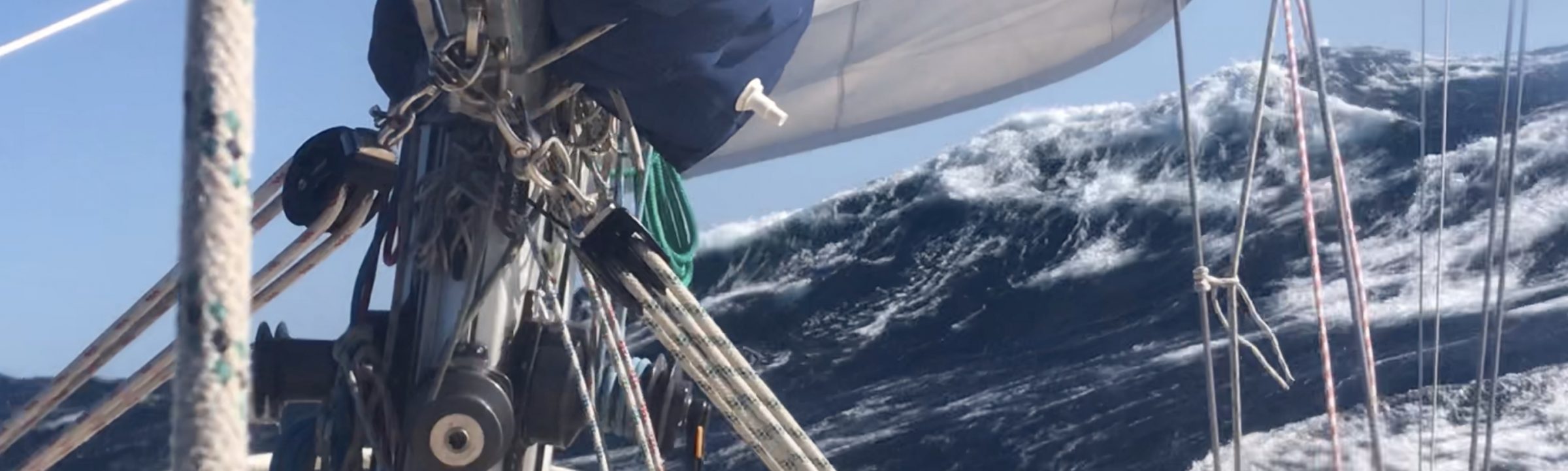
Two things.
First, the sky is squally. Before and after the squalls, cottony cumulus fail to obscure a backdrop of pale blue. In the squalls all is dark and gray and the wind freshens and there is a heavy rain.
Squalls we had in the Arctic, but they were rare, cold and arid; their cloud was snow white and diffuse, without obvious border. If they rained at all it was a dry-mouthed rain and their hail was vanishingly light.
These squalls now are torrential, a downward facing river; these are squalls of the open ocean.
Second, we’ve returned to the world of the albatross. The fulmars we first encountered off Greenland are again with us. So too are the chocolate brown petrels so numerous in the southern ocean. But to my surprise, today we have seen several Moli.
You may not know that the name of my companion these last months is what the native Hawaiian calls the Laysan Albatross. This bird is endemic to the North Pacific; it roosts on the island of Kauai and has a range (I had forgotten) well up into the Bering.
I have seen two today, big birds, gray of back, long of wing, short of tail and with that grace of flight I shall now forever associate with the loop Mo and I made of that vast southern sea. There such birds were the common flier, often around the boat in number.
So, two open ocean sightings–squalls and albatross. Thus this day I mark as our return to my home waters of the Pacific–this though I can see the heave of the Aleutians coming out of cloud to the south.


September 19, 2019
Days at Sea: 288
Days Since Departure: 354
Noon Position: 57 24N 167 25W
Course(t)/Speed(kts): SxE 6
Wind(t/tws): ENE 5+
Sea(t/ft): E2, S4
Sky/10ths Cover: Drizzle, 10
Bar(mb): 1002+, steady
On-deck Temp(f): 57
Cabin Temp(f): 65
Water Temp(f): 50
Relative Humidity(%): 49
Magnetic Variation: 8.4
Sail: Working jib and main; what there is of wind is on the beam.
Noon-to-Noon Miles Made Good (nm): 143
Miles since departure: 36,637

—-
Randall: Have you seen the weather forecast for the Gulf of Alaska, Monte? It’s looking pretty grim.
Monte: Senior, I do not consult your forecasts. A forecast it does one of two things. It makes you lazy, convincing you that you know something you do not, or it makes you afraid. To the inexperienced Jack, such as yourself, the usual effect of this latter phenomenon is that the ship it is reefed far too early, or maybe she does not leave port at all. No, Monte tells the weather by looking at the sky and feeling the wind on his face. That is enough for the true pilot.
Randall: Then I suppose you have a strategy for our coming passage home?
Monte: A strategy! Senior, do I look like that kind of man to you? I did not get these calluses by having a strategy! (Monte spits in disgust.) A boat it can only be steered from one wave to the next; it can only be sailed on the present wind. How can you plan for a storm three days hence when that storm may decide that instead of blowing it will spend the afternoon talking to the ladies by the fountain or maybe it will ride the horses up into the hills or maybe it will stay in its room with a bottle of madeira. Storms are that way, you know; what they will do cannot be known, and only a fool would have a strategy for what cannot be known.
Randall: Still, I wish I had a sense of how to slice the next two thousand miles after Dutch.
Monte: My friend, you do not ask the cook what is for dinner before he has done with the breakfast. If the crew does not falter and the gear does not fail, the boat she will go where she is meant to go and end up where she is meant to end up. What will happen cannot be foreseen by special inquiry.
Besides, I will always be there to grab your back.
Randall: You mean you will *have* my back.
Monte: Yes, that is what I said.
—
A heavy and threatening sky all day. Drizzle. Mostly calm. Light wind is now filling in from the NE. It is due to strengthen overnight and swing NW. A nice sailing wind for our last 170 miles into Dutch Harbor.
At this rate, we should arrive before sundown on Friday.


September 18, 2019
Days at Sea: 287
Days Since Departure: 353
Noon Position: 59 45N 168 97W
Course(t)/Speed(kts): SxE 7
Wind(t/tws): NE 18
Sea(t/ft): NE 10+
Sky/10ths Cover: Mostly clear; post-low cumulus astern. 3
Bar(mb): 997
On-deck Temp(f): ?
Cabin Temp(f): 57
Water Temp(f): 52
Relative Humidity(%): 68
Magnetic Variation: 8.1
Sail: All three sails flying. Wind on port quarter
Noon-to-Noon Miles Made Good (nm): 152
Miles since departure: 36,494

The barometer got as low as 991, but by 4am wind velocities hadn’t changed in hours and neither had the seas, which only rarely threw over Mo their loving embrace and were each time rebuffed with grace and charm. Having satisfied myself I’d seen what the low had to offer and that Mo could take care of herself, I finally went to bed.
Nights are growing longer, a full 12 hours at last count, and day feels slow to break. By 6am, the horizon is just hinting of light and sunup isn’t until around 9am. Aside from hourly status checks, I stayed in my bunk until full light.
Wind has been slow to diminish today, but slowly diminish it has. Now it is early evening and we’re in a lumpy calm and back on the engine. Must keep pushing the for miles.
The near-term goal is Dutch Harbor, 650nm from Nome and still 300nm further on as I type. And we’re on a schedule: arrival is planned prior to the next hefty low that will swing through the Aleutians on Saturday. We don’t have much time to spare.
From Dutch, we’ll launch for the final homeward leg, which looks to be a boisterous run of about 2,400 miles. The Gulf of Alaska is a chaos of strong and rapid systems, and to be frank, at the moment, I’m not sure how to slice it.
September 17, 2019
Days at Sea: 286
Days Since Departure: 352
Noon Position: 62 16N 167 36W
Course(t)/Speed(kts): SxW 7
Wind(t/tws): ENE 30
Sea(t/ft): ENE 10
Sky/10ths Cover: Overcast 10
Bar(mb): 1005, falling fast (995.5 by 8pm)
On-deck Temp(f): N/A. thermometer broken.
Cabin Temp(f): 54
Water Temp(f): 48
Relative Humidity(%): 58
Magnetic Variation: 8.4
Sail: Working jib rolled up by half; broad reach.
Noon-to-Noon Miles Made Good (nm): 146
Miles since departure: 36,342

I rode the twin headsails all night and Mo burned up the road. But by dawn, wind had veered too far into the E to hold them longer. I doused the poles before coffee and while the sky was still red at the margins and only then noticed wind was already well over 20 knots. Even with half a jib, we were fast.
That’s been the configuration all day–a double rolled jib pulling at the bow and Monte holding sway over the tiller at the stern.
With the masthead anemometer out of commission, I can’t tell you exactly the day’s wind speeds. From experience, I can say that 30 – 35 knots with higher gusts would fit the seas and the sail configuration.
The seas, however, are of the stocky, stand-up variety (except when I try to get them on camera), and there is the feeling of randomness about them. Working through is more like shooting rapids than maneuvering in a gale at sea. Not too surprising as the seas haven’t really room to move, room to mature. The water hasn’t been any more than 80 feet deep all day.
Mo is doing well. Monte is pulling with heart. But the skipper is uneasy. The barometer just goes down and down…


September 16, 2019
Nome, Alaska

I was climbing down the pier ladder to the boat when I heard a hail. “You’ve been one-upped,” yelled a man standing over where Tecla had moored the previous night.
“Not likely,” I replied before I could check myself.
Tekla is an unusual vessel, a steel-hulled gaff ketch built in the Netherlands in 1915 and recently restored. Now she’s a sail-training vessel that’s just completed the Northwest Passage. A small crowd had gathered to admire her, and among them, this man; gray-haired; short of stature and wearing a blue jacket and sock cap.
“Isn’t she beautiful is what I mean,” said the man walking toward me and sticking out his hand. “I’m sure your boat is a beauty too. My goodness look at that,” he said, leaning over the pier to stare at Mo. “By the way, I’m Richard Beneville. I’m the mayor of Nome. Thank you for visiting our fair city. We are so honored to have you and the other adventurers in town. When I was young, I used to have a local TV show–your story would be so perfect for our seniors–I mean, you do what we all dream…”
A pleasant, ten-minute conversation ensued during which I was only required to nod and smile.
—
Mo and I departed Nome after lunch. The goal is to get to the Aleutians and Dutch Harbor, 650nm south and a touch west, before the next big storm. Sadly, we will have to plow through a gale to do that. The gale will come on tomorrow around noon and last a day. Winds will be 30+ from the E and NE.
Granted, those aren’t big numbers, but when the current is strong and the water, shallow (50 miles off shore now and the depth is 70 feet), seas get heavy in a hurry. I’m all for going fast as long as nothing (more) carries away.


September 15, 2019
Nome, Alaska

One thing singlehanding teaches is the beauty of uninterrupted sleep. Even if he wakes naturally a time or two on that first night, once in port, the sailor’s shedding of responsibility and an unmoving bed are the sweetest luxury.
Next day to chores. The fuel truck was called and tanks filled but not jerry cans. Their time is past, and I gave half of them away to other boats. From here on extended calm should be the least of our worries. In the afternoon, a complete oil and filter change by way of a thank you to Big Red. A little shopping (top of the grocery list: pastry and fresh bread). A steak dinner. Alaskan beer.
Then it was time for a brief wander…
The towns of Alaska are unique in ways not found in the Canadian or Greenlandic north, and emblematic of this uniqueness is the great number of reality TV shows that have sprung up along its shores. Dutch Harbor has its “Deadliest Catch;” Homer, “Alaska the Last Frontier.” In Nome, the pay dirt is mining and the show, “Bering Sea Gold.”
Gold is Nome’s claim to fame, but the mining is not done in the nearby creeks and rivers so much as in the wide, shallow and sandy-bottomed bay just to the south. Thus, instead of fishing boats, the harbor is chockablock with dredges of all sorts. Most are small, home-built contraptions that look barely fit enough to sink properly. A few are large, gangly barges that follow the same theme.
One of my first sights (sorry, I was too arrested to take a photo) was a fight along the wharf between a small dredge owner and his wife. It was a screaming match that lasted hours. Take after take with the lone cameraman moving between the dredges and the wharf for clever angles.
Another famous descriptor is that “in Nome you will find more bars than churches.” I did not attempt a count, as such, but I discovered on my hike only three churches whereas on the town’s main drag, a person could stagger from one bar to the other without becoming overly winded.


Hi awesome friends of the Figure 8 Voyage
Well after long conversations about logistics, weather, Fleet Week and other shenanigans we’ve landed on a return date.
Randall and Moli plan to sail under the Golden Gate Bridge sometime on Saturday October 19th 2019.
If you’d like to be there (on land or on a boat) please make sure you’ve registered with us as we’ll be sending day-of logistics through email and not on here. If you haven’t sent us your information please do so using this link.
We’ll also looking for help with a couple of things. If you’re able to help with any of the following shoot us a note to figure8voyage@gmail.com
- We’re looking for someone who’s a member at a Yacht Club either in Sausalito, San Francisco or Tiburon and could help us with getting us a guest slip and space to have a welcome reception.
- Does anyone have a drone/camera situation and interested in getting on the media boat to video the sail in and under the bridge?
- We’re probably going to need some other “hands on the ground” on arrival day for various needs. If you’re up for volunteering let us know.
Please note. For any of you who’ve been on a boat for a more than a weekend, you’ll know that the weather can throw a monkey wrench in all of this. We’ve put in what we think is a decent buffer and Randall is VERY eager to be home, just know that things happen.
Lastly – as a little extra. Podcaster Ben Shaw interviewed Randall while he was in Nome Alaska. Lots of Q&A about navigating through the ice of the NWP. Enjoy!
September 14, 2019
Nome, Alaska

Mo makes her slow way against this implacable current and night drags on. A full moon, lights ashore glimmer across the glassy water. Two tankers appear as dark hulks on the horizon; they are anchored miles out and still only in 60 foot water. Even now tugs are ferrying their cargo of fuel to the town of Nome, which draws ever so reluctantly closer.
Midnight. Into the fairway. Alioth has already radioed an invitation to raft alongside. “We have a group here; people want to see you,” says Vincent.
I turn the corner and there, sandwiched between two dredgers, is silver Alioth and a crowd in the cockpit. There is clapping, a cheer for Mo. I nose in slowly. Hands reach out to catch the bow; other hands grab rails and lines and Mo is eased into place.
The crew of Morgane, Mirabelle, Opal, and Alioth, all now Northwest Passage veterans, have seen Mo safely in, after which we repair to Alioth’s cabin for a toast and the the sharing of stories until 2am.


September 13, 2019
Days at Sea: 284
Days Since Departure: 349
Noon Position: 64 57N 167 16W
Course(t)/Speed(kts): SE 6-7
Wind(t/tws): NE 15
Sea(t/ft): NE 2
Sky/10ths Cover: Overcast 10
Bar(mb): 1001+ and rising
On-deck Temp(f): 53
Cabin Temp(f): 57
Water Temp(f): 53
Relative Humidity(%): 63
Magnetic Variation: 8.6
Sail: Working jib and main, broad reach on port.
Noon-to-Noon Miles Made Good (nm): 118
Miles since departure: 36,138

Shifting winds overnight and our close approach to Cape Prince of Wales kept me up until 4am. Admittedly, I did nap in the pilot house, wrapped boots and all in a sleeping bag and with my head on the binocular case for a pillow. That’s the kind of sleep I’ve gotten these last three nights. It’s beginning to wear.
Also wearing is this blasted counter current. We’ve been making fast time since the low arrived, fast time through the water, but over the land the number is often 4.5 knots. It’s discouraging to see your boat drive so well but with so little to show for it. Or to spend all night approaching a cape, to finally make the turn, to decide a couple one-hour sleeps in the bunk are safe now, and then to wake with the sun to find the boat doing 7 knots, but the cape is right where you left it!
No matter the look of things, progress has been made. Nome is 18 miles E as I type. We should arrive before midnight.
—
In hindsight, I’m not sure why I thought that a Northwest Passage was defined as “a route over Canada and Alaska from Arctic Circle to Arctic Circle.”
Referees for something so esoteric are not easily found, but my source was a good one–the annually published Transits of the Northwest Passage by R. K. Headland of the Scott Polar Research Institute. However, when I went back to his summary for 2016, I found no such reference. Quite the opposite; Headland states the passage is from the Atlantic Ocean to the Pacific Ocean or the reverse.
Victor Wejer, Mo’s ice guide these last weeks, was quick to point out my error. “Crossing the Arctic Circle is nothing,” he wrote with his customary subtlety. “You have to get to the Pacific Ocean, i.e. the Bering Sea. That Arctic Circle theory is just fancy imagination.”
That was another bit of learning. The Bering is considered a “marginal sea of the Pacific Ocean.” Which is to say that when we rounded Cape Prince of Wales overnight and passed south through the Bering Strait, we not only (officially) completed the Northwest Passage, we also reentered the Pacific Ocean. My goodness, we’ve not seen hide nor hair of this ocean since last March.


September 12, 2019
Days at Sea: 283
Days Since Departure: 348
Noon Position: 66 54N 167 71W
Course(t)/Speed(kts): SxW 7
Wind(t/tws): E 25+
Sea(t/ft): E10+, steep and breaking
Sky/10ths Cover: Overcast 10
Bar(mb): 995 and falling
On-deck Temp(f): 51
Cabin Temp(f): 57 (no heater today)
Water Temp(f): 48
Relative Humidity(%): 60
Magnetic Variation: 8.3
Sail: Triple reefed main and working jib, reach.
Noon-to-Noon Miles Made Good (nm): 141
Miles since departure: 36,020

We had a fine sailing breeze after rounding Point Hope last night–full sail, wind abeam. But by 2am I was reefing and by dawn I had three reefs in everything and was all out of reefs. Mo flew, but it was hard work.
The real story during this blow–the seas. The wind has been strong, but at 30 knots it’s been nothing to write home about, except for what it’s done to the water. The Coast Pilot reports that current here flows N at 1 – 2.5 knots over an uneven bottom that is shallow throughout the entire Chukchi. The wind overnight was mostly E but had a N component to it. Result: by mid-morning we were wrestling with vertical and crashing 10 – 12 foot seas on the beam.
With water flying everywhere, I was glad I’d buttoned Mo up tight over these last two days.
We’ve had plenty of practice with riding the edge of seas like these in the southern ocean. Sometimes down there the approaching low and our course were out of sync, and we’d have to ride the first phase of a 30 to 40 knot blaster with seas abeam, much bigger seas than these. You get used to judging what the boat can take; where her “tipping point” might be. Bottom line: as long as she’s moving fast, Mo is rock-solid, even when fully broadsided.
That’s the rational brain talking by the way. The brain I live in isn’t so sanguine when Mo is T-boned by a Mac truck that puts her windows in the water. I’ve been biting my nails all day.
Wind is easing now, but the current against has done us no such kindness.
156 miles to Nome. Still 30 hours further on at this pace.
—
At 4:30pm local, Mo and Randall passed south of 66 34N at 168 06W and in so doing crossed the Arctic Circle. We are now officially out of the high north. What’s more, we have completed a Northwest Passage, which is defined by some as a route over Canada and Alaska from Arctic Circle to Arctic Circle.
We entered the Arctic on July 27 and exited on September 12 for a passage length of 47 days and a sailing distance of 3,035 miles.
This is Mo’s third Northwest Passage. Her first was as Asma with Clark Stede and Michelle Poncini in 1990, and her second was as Gjoa with Glenn and Ann Bainbridge in 2014/15. But this is her first solo run. Mine too.


(September 13 note: In hindsight, I’m not sure where I got the idea that an Arctic Circle to Arctic Circle route is a Northwest Passage. More on that tomorrow.)
September 11, 2019
Days at Sea: 282
Days Since Departure: 347
Noon Position: 69 06N 165 53W
Course(t)/Speed(kts): SSE 5
Wind(t/tws): ExS <10
Sea(t/ft): E 3
Sky/10ths Cover: Overcast 9
Bar(mb): 1005+ and falling
On-deck Temp(f): 51
Cabin Temp(f): 68
Water Temp(f): 52
Relative Humidity(%): 53
Magnetic Variation: 9.3
Sail: Working jib and main, reaching to port
Noon-to-Noon Miles Made Good (nm): 153 (another 26 hour day so as to get ship time into the local zone.)
Miles since departure: 35,879
Miles to Nome: 332

I’ve swung in close to Cape Lisburne for the view. When passing here in 2014, cloud was low and Lisburne was a black hump to port, but even a partial sighting of high cliffs dropping vertically into the sea revealed this as the most massive land feature we’d seen since Greenland.* Today confirms that recollection of an impressive Cape.
The US Coast Pilot has this to say about Cape Lisburne, “[It] is a bare brown mountain 849 feet high [and] distinctively marked by … pinnacles and rocks near its summit, and its shore faces are very steep. The cliffs are rookeries, and during the summer months the sky is sometimes darkened by the flights of birds. The wind rushes down from the mountains in gusts of great violence and varying directions, and at such times passing vessels should stay well off the cape.” [USCP9, p. 454]
By dawn we had wind enough to sail; by 8am, the engine was off and Monte back in action. I repeat, my good friend Monte was at the tiller and for the first time since the sail across Lancaster Sounds. We felt like a ship again.
I spent the morning on last chores in preparation for what will be big winds over the next two days.
-Transfer more fuel from jerries into tanks so as to get weight out of the bow.
-Move the dinghy from its lashing on deck and into the anchor locker.
-Rig the jib sheets for heavy weather.
-Cover windlass and lash anchor in place.
-Lock hatches and floorboards.
-Top off autopilot and engine fluids.
-Bathe.
That last line item is a habit that’s developed over time. No, it’s not that I wait for an imminent blow to get clean, but I’ve found it’s nice to be clean when the s***t hits the fan.
I paid for my vista of Lisburne after noon when the wind died in its shadow. Engine back on. And now we plunge dive into a tall SE swell. No sail up at all; it was just beating itself to death. Thirty miles south are twenty-knot easterlies. But they re not for us. Not yet.
*Alaska’s Brooks Range, spotted a few days ago, was hidden by cloud in 2014.


September 10, 2019
Days at Sea: 281
Days Since Departure: 346
Noon Position: 70 47N 160 77W
Course(t)/Speed(kts): WSW 5.5
Wind(t/tws): ENE 12
Sea(t/ft): ENE 2
Sky/10ths Cover: Rain 10
Bar(mb): 1007, falling slowly
On-deck Temp(f): 51
Cabin Temp(f): 63
Water Temp(f): 49 (49!)
Relative Humidity(%): 49
Magnetic Variation: 11.2
Sail: Twins poled out full
Noon-to-Noon Miles Made Good (nm): 115
Miles since departure: 35,726

Note the warm water in the above stats, 49 degrees. Just three days ago we were recording water temperatures of 31 degrees.
—
Around noon, wind we had, a beautiful following wind. Not in the forecast, but who’s complaining. I poled out both headsails, lowered the main, shut off the engine. Wind increased. Suddenly we were doing 7 knots where all night 4.5 was the norm. I made up lines and went below to congratulate myself with a piece of toast and jam.
Before the other side of the bread was even warm, wind went E. By the time I got the poles down and all plain sail set for wind abeam, it had died right away.
Engine back on at 1pm. God bless and keep Big Red.
—
In the afternoon I continued getting ready for the coming low. By Thursday, this whole sector will be E25 – 30. That’s more wind than we’ve had under sail since the Atlantic, and neither Mo nor Randall are quite ready.
Today I transferred fuel from jerries into the main tanks so I can get the jerries off the deck. While stowing the empties in the forepeak, I took the opportunity to lighten load by tossing over the side some canned goods that hadn’t fared well. They were rusty and bent and probably would do in a pinch, but we’re coming to the final leg of this voyage, and I still have mountains of food. So we made an early donation to Neptune’s Holiday Drive. Ten cans of Chef Boyardee Raviolis. Enjoy!
This afternoon, glassy water; within it, scads of jelly fish, all heading south for the winter. Floating on top, one dead seal; winter migration no longer a worry.
—
We are rounding Icy Cape as I type. The promontory was named by Captain James Cook in 1778 as he explored these waters in search of the Northwest Passage. The month was August, and ice still clung to the coast. Cook would be turned back by pack ice just a few miles further on; thus, Icy Cape effectively represents Cooks furthest north.
Cook’s experience was not extraordinary. When Frederick William Beechey discovered and named Point Barrow in 1826, he could not reach it by ship, but rather had to send boats ahead. Likewise, Franklin was kept from Point Barrow by ice in 1826. In 1837, Thomas Simpson walked the final 50 miles when his boats were stopped by ice, and only in 1849 did William Pullen round the point in two whale boats, this after sending two larger, unsuccessful boats back to the ship. [source Wiki]
I have swung close to Icy Cape so as to take the measure of it, but this year it is buried in cloud rather than ice. There is nothing to see.


September 9, 2019
Days at Sea:280
Days Since Departure: 345
Noon Position: 71 28N 154 46W
Course(t)/Speed(kts): W 6
Wind(t/tws): S <15
Sea(t/ft): SW 3
Sky/10ths Cover: Clear, a hing of cloud landward 3
Bar(mb): 1010
On-deck Temp(f): 53
Cabin Temp(f): 68
Water Temp(f): 45
Relative Humidity(%): 55
Magnetic Variation: 14.5
Sail: Main and working jib; close reach
Noon-to-Noon Miles Made Good (nm): 158 (Today was a 26 hour day, as I set the clock back two hours so as to get into local time.)
Miles since departure: 35,611

At 2am, I switched off the engine, and we sailed on a close reach for a solid twelve hours before calling it back into action. Not since Halifax have we sailed so long. The boat felt suddenly such sweet quietness and full of a gentle, animated motion, as if she were a great gray beast galloping over the waves.
In the morning, I was greeted by a coppery sun and a flock of Kittiwakes above the mast. They hung by for several hours, apparently inspecting Mo for defects from height. None found, they departed at noon.
All day the wind slowly eased. When our speed dipped below 3 knots, I switched on Big Red.
Now we have turned south for the final rounding of Point Barrow. Wind is very light, but a SW chop remains and stops Mo in her tracks every few minutes.
South. I repeat. At 71 28N and 155 58W, we have turned south. From now on, every mile will bring us closer to home.
—
Months ago, a comment on the Figure 8 site read something to the effect of, “if you stop at Point Barrow, we would be happy to have you as our guest. The food will be hearty, though the conversation may be less than scintillating.”
I have thought of that kind offer many times on this leg. A home-cooked meal would be most welcome, and I’m sure the conversation would be more than satisfactory.
All day I’ve been nursing the fantasy of receiving an urgent call on the VHF. As I pass by town, the radio would sing out, “Moli Moli Moli…dinner is on the table!” To which I would turn to, after a shower, of course and prior to which no amount of scintillating conversation could cover up the fact that I am well past my sell by date.
Thank you to my unknown friend in Barrow for the invitation, and I wish that it were possible. But we yet have “miles to go before we sleep.” Miles and miles.


September 8, 2019
Days at Sea: 279
Days Since Departure: 344
Noon Position: 70 52N 146 50W
Course(t)/Speed(kts): WxN 6
Wind(t/tws): SE <10
Sea(t/ft): SE 1
Sky/10ths Cover: Overcast. Clear earlier, rain later. 10
Bar(mb): 1009+
On-deck Temp(f): 43
Cabin Temp(f): 65
Water Temp(f): 36
Relative Humidity(%): 40
Magnetic Variation: 17.6
Sail: Motoring, main up.
Noon-to-Noon Miles Made Good (nm): 146
Miles since departure: 35, 453

That’s the thing about the Figure 8–there are just so many many miles of it…
A not very interesting stretch of water, this. The sky is hung with cloud that now and then sends down enough rain to wet the boat without giving it a rinse. The wind, when there is wind at all, is so light as leave the main unperturbed as it hangs from the mast like so much laundry. Sometimes there is a seal to break the smooth surface of the water. If ever there is a bird, it’s a seagull, the pigeon of pelagics.
A good breeze briefly this afternoon. We sailed for twenty minutes with the engine off. Such sweetness, a hull sliding silently through the water. Then calm again and on came the engine.
Overnight, auroras through a thin haze, green curtains undulating above the mast. It is surprising how fast they move, whipping a whole length of sky in mere minutes. Sadly, they make poor pictures.
One domestic joy: only recently have I learned to toast bread on the diesel heater, a watershed moment on Mo! Sure, one can use the galley oven for this, but it’s a fiddle. Now, every morning I have buttered toast with jam.* For lunch, I spread on some of the Danish delicacies that were my last purchase in Sondre Upernavik, liver pate and pickled cabbage.
At this pace, twenty-four hours to Barrow. Then the fun begins.
*I departed San Francisco with enough jam to sink a ship, all homemade and by two very good friends, Jim and Kelton. Each friend gifted me with a quantity from his own kitchen that was, alone, enough for the voyage, and I thought for sure I’d return with a hold still full of jam. I will not. I may actually run out.


September 7, 2019
Days at Sea: 278
Days Since Departure: 343
Noon Position: 70 25N 139 36W
Course(t)/Speed(kts): WxN 6
Wind(t/tws): ExS 5
Sea(t/ft): E 1-2
Sky/10ths Cover: Clear, 0
Bar(mb): 1015, steady
On-deck Temp(f): 45
Cabin Temp(f): 65
Water Temp(f): 37
Relative Humidity(%): 41
Magnetic Variation: 19.7
Sail: Under power. Main up, doing nothing.
Noon-to-Noon Miles Made Good (nm): 148
Miles since departure: 35,307

8am. Sunup. On deck temperature: 35 degrees Fahrenheit. Water: 31. Water temperature the previous afternoon had been 46 and the day had been warm. Remembering that such temperature drops can be signals of approaching ice, I scanned the horizon to the N, a tricky business in fog. I saw nothing. I switched on the radar. It too saw nothing.
By midmorning, the fog had burned away, revealing empty water to starboard. But off our port bow a high, snowcapped mountain range came hull up on the horizon. I don’t recall seeing any tall land in 2014 prior to Cape Lisburne, but there they were, the Romanzof Mountains, part of the Brooks Range. Part of Alaska.
Just then we were forty miles N of Herschel Island, the site of an old whaling station and trading post and where I was told the local Canadian Rangers extend a warm welcome to visiting yachts. This welcome includes use of the sauna and a champagne dinner and was one of the reasons for pushing Mo so far N right out of Tuk. I didn’t want to be tempted.
Wind went calm at midnight and has continued in it truancy all day, and the only remarkable thing upon the water has been the sighting of a few driftwood limbs prior to noon.
One definition of the Arctic Circle is that latitude line above which trees do not grow. As there was nothing taller than cotton grass in Tuk, I was surprised while walking the town to find an old Inuit meeting house built of driftwood and a beach choked with same (both pictured yesterday). I assumed these and today’s wood must have come from many many miles to the S via the nearby, north-flowing MacKenzie River. While this still may be accurate, it was interesting to read today in a summary of Tuk geography that it is “located on the Arctic tree line.” A forest must have been closer than I thought.
Mo passed over Demarcation Point at 141W a couple hours after noon and so has re-entered US waters via Arctic Alaska. I will admit that Alaska does feel like home. But we are so far off shore now that a photo of the mountains does not come out, and we are still a very long way from safe harbor.
It’s 330 miles to Pt. Barrow, then another 500 miles to Nome, then 3,000 more to the Golden Gate Bridge.


September 6, 2019
Tuktoyaktuk, Nunavat

Another long night of sleep with no thought to course or speed or set of sail. Just sleep.
In the early morning, a light breeze from the SE and a low overcast that allowed but a sliver of blood orange sun as it crested the horizon.
Quietly I rose, crossed Mandragore’s decks to the pier, and hiked the town before it was fully awake.
I departed just after 10am.
Point Barrow is 500 miles to the W. Nome, another 500 miles further on.


September 5, 2019
Tuktoyaktuk, Nunavut
Days since Departure: 343

Mandragore, containing her crew of Pablo and Pablo, made Tuk this morning, and together we warped to the pier next to the Northern store for fueling and watering.
Fuel can be taken by jerries from the store pumps, a distance of 200 feet, or by calling a truck to the pier, and while the former requires hoofing one’s heavy cans, it avoids the delivery charge of the latter. We both chose hoofing it.
I had the more fuel to take (100 gallons) and the more cans to transport. Without the slightest hint of request, and even against explicit protest, Pablo and Pablo did most of Mo’s fuel carry while I pumped.
We were fueled by noon.
Mandragore’s water needs were a different story. For this a truck had to be called, even though Pablo required but 200 liters (about 50 gallons). I made the arrangements by telephone with the wife of the driver, Karen, who informed me that for sailboats there was a delivery fee of $150 per hour.
“And how much is the cost of the water?” I asked.
I could here the clicking of a calculator. “Well, for 200 liters…let’s see…that would be… about $5.”
“Per liter?” I whistled through my teeth. “Good water, eh?”
“No,” said Karen in that unruffled monotone of the Inuit. “Just $5.”
I questioned the surprising differential between the two fees, to which Karen responded. “Once we had a sailboat come in and it took three hours to fill their tanks. We could only charge them for the water; I think it was $12, but Peter had to work all afternoon for them and they were very slow. So now we charge by the hour for sailboats.”
The incentive worked marvelously. Pablo’s tanks were full to overflowing within twenty minutes.
—
Water aboard, Pablo and Pablo were free for the day, but my chores continued.
The blown working jib had to be changed for the spare and the stripped main batten pocked repaired, engine liquids needed checking and topping off, and late in the day a surprising number of over-stuffed white trash bags were unearthed from Mo’s forepeak and donated to the municipality of Tuktoyaktuk.
I felt bad about this latter act until I tallied the day’s receipts. Fuel, a burger, a cold coffee and a small bag of groceries, including a $16 frozen cowboy steak and a $9 box of spinach, came to nearly $900.
I don’t mean to suggest that those passing through are being gouged. Rather, the high cost of pretty much everything up here reflects the difficulty of getting it here in the first place. The sum did, however, serve to reduce my guilt at leaving behind a haul of refuse.


September 4, 2019
Days at Sea: 276
Days Since Departure: 340
Noon Position: 69 56N 132 25W
Course(t)/Speed(kts): SW 5
Wind(t/tws): SE <10
Sea(t/ft): SE 1
Sky/10ths Cover: Altocumulus 9
Bar(mb): 1011
On-deck Temp(f): 44
Cabin Temp(f): 57
Water Temp(f): 38
Relative Humidity(%): 50
Magnetic Variation: 20.9
Sail: #1 and main, full; wind on the beam.
Noon-to-Noon Miles Made Good (nm): 135
Miles since departure: 35,128

The strangest thing about yesterday was that two hours after rounding the top of the Baillie Islands, a large raven flew over the boat. The color pallet for pelagics favors white and pale grays. When a bird is dark in color, it goes as far as a rich, chocolate brown. But there is no such thing as an all-black deep sea bird, not to mention one so pure in its blackness that its wing stroke ricochets the sun as silver bullets.
Ravens are not unknown of up here; I heard their bell-like call in the village of Pond Inlet, and Alvah Simon talks of a raven that spent the winter with him in Tay Bay. But this is the first one I’ve seen so far from an outpost. I flew below for a camera, but by the time I regained the deck, it was gone. Not receding toward the horizon and out of shot–just gone.
We must have been five miles offshore when we received the visit. From deck level, the view was all water, brown as the River Nile. We were in the lee of the islands now. Wind was off the land, and I distinctly recall the smell of pine trees, though trees must be absent from here to at least five degrees further south.
The sun, the turbid water, the land bird, the earthy smells, were more reminiscent of sailing the back bays of home rather than a thin strip of water between Arctic Ocean ice and the barren rock of extreme northern Canada.
—
All day the water remained shallow and opaque. Brown to clay to a muddy emerald color and then back to brown. In the night we were overtaken by a long-tow tug, the Henry Cristoffersen, also bound for Tuk. With binoculars, I could see the white of its superstructure astern and aft of it three large barges.
About this time I realized the SW course-line I’d carelessly set on the chart plotter took Mo over a number of drying shoals further on. Working back out into deeper water crossed the tug’s bow in a way that made us both nervous. It slowed, I sped up as best I could. Mo wasn’t safe and back on course until early morning.
—
From here on, wind we had. We motor-sailed over Baillie and then went full sail with the breeze abeam. In the night, the working jib split again and right at the patch applied in Halifax. Then I noticed that a batten pocket on the main had come free of its pin. Jobs for Tuk.
—
Shallow shallow all the way. But no grounding and anchor down two hours before sunset off the pier and Northern store. Mo is so still as to not be floating at all. Next, uninterrupted sleep.


September 3, 2019
Days at Sea: 275
Days Since Departure: 339
Noon Position: 70 16N 125 53W
Course(t)/Speed(kts): WxN 5.5
Wind(t/tws): E 15
Sea(t/ft): SE 3
Sky/10ths Cover: Clear 0
Bar(mb): 1015, steady
On-deck Temp(f): 45
Cabin Temp(f): 65
Water Temp(f): 32 (ice is near)
Relative Humidity(%): 35
Magnetic Variation: 20.7

Sail: Under engine; full sail as well.
Noon-to-Noon Miles Made Good (nm): 132
Miles since departure: 34,993
After sunset, I slowed Mo so that I could sleep. The reason for the slowing was that as we approached Cape Parry, our clear water would become what the ice charts classify as “<1/10th concentration” (the pale blue color on yesterday’s graphic).
What this has meant before is, at worst, widely dispersed growlers and bergy bits, and at best, nothing at all.
Night is dark now; the chances of seeing small ice are nill, so I tried to punt entering the “<1/10th” area till 5am.
I slept poorly. The zone boundaries on ice charts are estimates. And besides, approaching ice, even at distance, and sleep just don’t work well together. But I persisted until 4am, when I just couldn’t stay down any longer.
By now dawn was on the make. I slid open the companionway hatch and climbed on deck. What met my view was a field of growlers no more than five minutes distant. We had to divert for one of the hefters on the quick.
—
From Cape Parry, I steered due W, as per the plan discussed yesterday. By breakfast, Victor had forwarded the day’s wind reports, strong easterlies pushing the ice back toward shore. I could get pinned in. “I’ll keep an eye on you,” said Victor, reassuringly, but from his home office in Montreal.
The early field of growlers was not reproduced as the morning brightened, but by 10am I saw a large line of white to the S, a high and ugly looking pod of pack ice. Ahead remained clear. An hour later, a similar pod crossing almost the entire horizon to the north. Again, ahead remained clear.
By 1pm I hadn’t seen any ice for two hours. I turned Mo toward the Baillie Islands, which we rounded to the N without difficulty at half past seven. The sun set two hours later over a clear sea.
Baillie is the last pinch point in Canada–insert sigh of relief. The next worry, if you are the worrying sort, is Point Barrow.
Tuk is 130 miles more to the W. Then home is but two or three more leaps further on.

September 2, 2019
Days at Sea: 274
Days Since Departure: 338
Noon Position: 69 41N 199 42W
Course(t)/Speed(kts): WxN 4.2
Wind(t/tws): W 5
Sea(t/ft): NE 1
Sky/10ths Cover: Overcast 8 (Squalls with light snow till noon)
Bar(mb): 1019
On-deck Temp(f): 40
Cabin Temp(f): 65
Water Temp(f): 36
Relative Humidity(%): 34
Magnetic Variation: 19.5
Sail: Under power.
Noon-to-Noon Miles Made Good (nm): 119
Miles since departure: 34,807
Miles to Tuk: 300
Little to report but progress, slow progress. We are motoring on a flat sea now and at the usual clip, but there is a current here in the Amundsen Gulf of 1 – 2 knots against, so much of the time we are making but 4 knots to the good. Granted, they are an easy 4 knots, except for the impatience of the skipper to be onward.
Snow on deck this morning from nearly stationary squalls ahead. Big, clumpy flakes. Even with 6am temperatures of 36 degrees, the snow hardly lasted a minute.
After the sky cleared, flocks of snow geese headed S and W in long Vs just above the water top. Now and then a grebe going where ever grebes go. Twice Mo scared the pants off a seal as it came up for air.
Gradually, wind is swinging into the NE but is still too light to be useful. Sails are up; they hardly draw. Big Red continues to do all the work, has run for the last 31 hours without a break.
All the NW wind of late has pushed a big chunk of old Arctic ocean ice down and around the Baillie Islands and Cape Bathurst. Thus, my joy at being out of the ice as expressed in the following video may have been premature. The ice is not currently up against the coast, and I think it can be easily avoided by a jog due W at Cape Parry. Tomorrow’s forecast will tell.

This video is about how we got through the last big ice block in Larsen Sound.
September 1, 2019
Days at Sea: 273
Days Since Departure: 337
Noon Position: 68 48N 114 43W
Course(t)/Speed(kts): N 4
Wind(t/tws): NW 10+
Sea(t/ft): NW 3 – 4
Sky/10ths Cover: Overcast, some light snow. 10.
Bar(mb): 1022+
On-deck Temp(f): 38
Cabin Temp(f): 64
Water Temp(f): 39
Relative Humidity(%): 33
Magnetic Variation: 16.9
Sail: Under power; main 1 reef
Miles since departure: 34,688
Winds are finally diminishing, but out in Dolphin and Union the short, stocky sea is still pushing Mo around. Not going to be fast for a while yet.
I remember the point during the 2014 Northwest Passage when I’d had enough, enough engine racket, enough of being stuck in a cabin that was either too cold or too hot, enough of the what-if-we-dont-make-it-then-what worry. That point was three days after Tuk on the 1000 mile run over the top of Alaska to Nome.
Jump forward to now, a few hours out of Bernard Harbor. Tuk is still 420 miles in front of us, and I’m already at that point. I chafe at the confined waterways and headwinds, the unbearably flat land. Though I’m thrilled that Big Red is doing well, I tire of depending on him. I tire of the noise and the boredom that comes with days and days of motoring. I tire of the constant feeling of exposure and vulnerability; the knowledge that the risks I’m running here are large, the consequences real.
To quote Vonnegut, “So it goes.”
There is a line that’s popular with sailboat cruisers today: “We will do this as long as it’s fun.” It’s why I’m not a cruiser. Fun is a terrible organizing principle.
Many days on Mo are quite dull, a few are downright terrifying, most are made up of chores and the unexciting routine of shipboard life. When all those days are strung together and viewed as a complete voyage–a voyage that one envisioned, prepared for and pursued, largely on ones own–then they become a thing of deep satisfaction. But the fun had along the way is hardly worth noting.
—
Here is the second video put together at Bernard Harbor. Sailing through ice and fog. One of the strangest days yet.
August 31, 2019
Wind: NW15-20
Sky: Low and squally with SNOW
6am Temperatures–
On Deck: 37
Cabin: 45 (before I fired up the heater)
Water: 39
Snow.
It’s too warm to stick, but that it’s falling at all I take as a sign. In the Arctic, the dog days of summer portend winter; autumn is coming quickly, and I’m but half way through the Northwest Passage. Half way and still pinned down by contrary winds in Bernard Harbor.
Where I live at the moment, inside the boat a quarter mile S of North Star Point, is comfortable enough, but within a month it will be untenable. Which is to say, frozen.
I’m not prepared for the ten month commitment required for overwintering here. I might just stretch food supplies by careful rationing, but I don’t have enough fuel to run the diesel heater all winter. What’s more, it’s not winter diesel. It would grow waxy and unusable just as real cold set in.
I have no choice but to keep moving.
But not today.
—
This lull has given me a chance to get caught up on videos. I’ve made three in one day based on footage from the last two weeks–i.e. Graham Harbor on Devon Island to Cambridge Bay.
Here is the first…
August 30, 2019
Wind: WNW20+
Sky: Low and squally with some pea-sized hail
6am Temperatures–
On Deck: 37
Cabin: 43 (before I fired up the heater)
Water: 40 (this is up from 33 degrees in Dolphin and Union)

The title of today’s report was going to be, “Images of a DEW Line Station,” but all day it has been blowing a three-quarter gale from the NW. Ragged cloud, rain and hail. Mo is pulling at her leash like a dog that’s not been walked in a week, and I don’t dare leave for the required hike inland to the abandoned site.
DEW Line, short for Distant Early Warning Line, refers to a collection of high-powered radar towers that are strung across Arctic Canada and Alaska like a pearl necklace. Built in the 1950s at the beginning of the Cold War, their purpose was to detect a Russian aerial attack hours before it could arrive and allow time for US and Canadian-based forces to get airborne and/or launch a counter-attack.
Why here? Because a great circle (i.e. shortest) route between Russia and the US passes over the North Pole.
The stations were designed to detect incoming bombers, not missiles, and so in the 1980s, many sites were upgraded with more powerful technology and renamed the North Warning System (NWA). Those stations no longer needed were abandoned.
Bernard Harbor was abandoned.
The strangeness of seeing these stations here cannot be overstated. Hour after hour of travel, there is only water and a land as flat and barren as the day it was called up from the deep. Then, in the distance, a tower with a white dome at its apex. In this place still “without form and void,” one is reminded of the conflicts of the modern world.
I could see this station when approaching the harbor but cannot from the anchorage. That said, the beach tells the tale. Here are stacked scads of rusted out fuel drums, and above them on the bluff are what appear to be two large fuel storage tanks.

—
Neither Fredoya, a yacht that arrived yesterday, nor Mo have moved. Moreover, a modern luxury ketch pulled in this afternoon to escape the strong winds outside and around the point.
And this evening I got word from Victor that all this north wind has driven the high Arctic ice pack down and over the Baillie Islands some 300 miles to the NW. This is a known pinch point on the Northwest Passage route, now covered in 5 – 6/10ths ice.
We are so close to the finish line, yet we are still so very far away. Even with 35,000 of the 40,000 miles under the keel, the list of potential voyage-stopping events is long. How easily that thin line connecting here and the Golden Gate Bridge could be broken.
It feels binary. Mo and I will remain far from the goal until we are finished. There is no near.


